Difference between revisions of "2012-08-27 -37 143"
From Geohashing
imported>Snaplatitude |
m |
||
| (4 intermediate revisions by 4 users not shown) | |||
| Line 1: | Line 1: | ||
[[Image:2012-08-27_-37_143_20-57-38-095.jpg|300px|thumb|left]] | [[Image:2012-08-27_-37_143_20-57-38-095.jpg|300px|thumb|left]] | ||
| − | |||
{{meetup graticule | {{meetup graticule | ||
| lat=-37 | | lat=-37 | ||
| Line 17: | Line 16: | ||
== Plans == | == Plans == | ||
| − | + | The hash for was in a public place so I thought I could get there without being stuck with another no-trespassing consolation prize. | |
== Expedition == | == Expedition == | ||
| Line 40: | Line 39: | ||
| − | |||
| − | |||
[[Category:Expeditions]] | [[Category:Expeditions]] | ||
[[Category:Expeditions with photos]] | [[Category:Expeditions with photos]] | ||
[[Category:Coordinates not reached]] | [[Category:Coordinates not reached]] | ||
| + | [[Category:Not reached - Mother Nature]] | ||
| + | {{location|AU|VIC|PY}} | ||
Latest revision as of 12:04, 21 April 2022

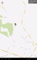
| Mon 27 Aug 2012 in -37,143: -37.3073534, 143.2671187 geohashing.info google osm bing/os kml crox |
Location
Halfway up Mount Cole.
Participants
Just Snaplatitude
Plans
The hash for was in a public place so I thought I could get there without being stuck with another no-trespassing consolation prize.
Expedition
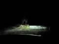
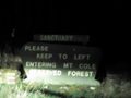
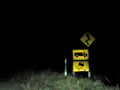
Headed off on a long drive out past Beaufort to the geohash. As I came through Beaufort the sun started going down and it was dusk. By the time I got to Mount Cole it was dark and spooky. I travelled along the roads as they became smaller and more treacherous. At one point I had to get out and drag a branch off the road so I could go on, then I realised how terrifying it was out there. I was almost decided to head back when I hit the wet, boggy track ahead and gave up. Chickened out :(
Photos
that's how close I got

Big Rock