Difference between revisions of "2022-06-02 42 -83"
ChiefPockets (talk | contribs) ([live picture]Hash point is roughly where the yellow guy wires meet the ground, beside the flagpole out front of a small apartment complex. [https://openstreetmap.org/?mlat=42.53258590&mlon=-83.14410660&zoom=16 @42.5326,-83.1441]) |
m |
||
| (8 intermediate revisions by 3 users not shown) | |||
| Line 15: | Line 15: | ||
== Location == | == Location == | ||
<!-- where you've surveyed the hash to be --> | <!-- where you've surveyed the hash to be --> | ||
| + | Downtown Clawson, MI, USA. Just off of Main St and 14 Mile, between a fire station and an apartment complex. | ||
== Participants == | == Participants == | ||
<!-- who attended: If you link to your wiki user name in this section, your expedition will be picked up by the various statistics generated for geohashing. You may use three tildes ~ as a shortcut to automatically insert the user signature of the account you are editing with. | <!-- who attended: If you link to your wiki user name in this section, your expedition will be picked up by the various statistics generated for geohashing. You may use three tildes ~ as a shortcut to automatically insert the user signature of the account you are editing with. | ||
--> | --> | ||
| + | *[[User:ChiefPockets|ChiefPockets]] | ||
== Plans == | == Plans == | ||
| Line 25: | Line 27: | ||
== Expedition == | == Expedition == | ||
<!-- how it all turned out. your narrative goes here. --> | <!-- how it all turned out. your narrative goes here. --> | ||
| + | What a day! Work ran a little long, then I had errands on opposite ends of town. I was hoping to visit here (as well as the neighboring [[2022-05-31 42 -83]]) on my way home, but it was late and I got sidetracked with a final errand. After dropping some things at home I left around 9pm for the trek to Clawson and managed to catch every single light red on journey. | ||
| + | |||
| + | The hash point is one of the more convenient I've visited. It's just off of two main roads, on a quiet street, and right next to the visitor parking spaces at an apartment complex. It was rather late at this point so my headlight was handy lighting for my picture. | ||
| + | |||
| + | For the return trip home I was desperate to avoid a similar experience with red lights, so I used a fun game I sometimes play called "slow roads only" and tried to spend as little time as possible on roads with speed limits above 25mph. I was very successful and only made two small wrong turns costing perhaps a minute combined. | ||
== Tracklog == | == Tracklog == | ||
| Line 42: | Line 49: | ||
<!-- Add any achievement ribbons you earned below, or remove this section --> | <!-- Add any achievement ribbons you earned below, or remove this section --> | ||
| − | |||
| − | |||
| − | |||
| − | |||
| − | |||
| − | |||
| − | |||
| − | |||
| − | |||
| − | |||
| − | |||
| − | |||
| − | |||
| − | |||
[[Category:Expeditions]] | [[Category:Expeditions]] | ||
| − | |||
[[Category:Expeditions with photos]] | [[Category:Expeditions with photos]] | ||
| − | |||
| − | |||
| − | |||
| − | |||
| − | |||
[[Category:Coordinates reached]] | [[Category:Coordinates reached]] | ||
| − | + | {{location|US|MI|OD}} | |
| − | |||
| − | |||
| − | |||
| − | |||
| − | |||
| − | |||
| − | |||
| − | |||
| − | |||
| − | |||
| − | |||
| − | |||
| − | |||
| − | |||
| − | |||
| − | |||
| − | |||
Latest revision as of 16:09, 10 June 2022
| Thu 2 Jun 2022 in 42,-83: 42.5325940, -83.1439905 geohashing.info google osm bing/os kml crox |
Location
Downtown Clawson, MI, USA. Just off of Main St and 14 Mile, between a fire station and an apartment complex.
Participants
Plans
Expedition
What a day! Work ran a little long, then I had errands on opposite ends of town. I was hoping to visit here (as well as the neighboring 2022-05-31 42 -83) on my way home, but it was late and I got sidetracked with a final errand. After dropping some things at home I left around 9pm for the trek to Clawson and managed to catch every single light red on journey.
The hash point is one of the more convenient I've visited. It's just off of two main roads, on a quiet street, and right next to the visitor parking spaces at an apartment complex. It was rather late at this point so my headlight was handy lighting for my picture.
For the return trip home I was desperate to avoid a similar experience with red lights, so I used a fun game I sometimes play called "slow roads only" and tried to spend as little time as possible on roads with speed limits above 25mph. I was very successful and only made two small wrong turns costing perhaps a minute combined.
Tracklog
Photos
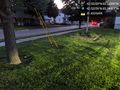
Hash point is roughly where the yellow guy wires meet the ground, beside the flagpole out front of a small apartment complex. @42.5326,-83.1441
