Difference between revisions of "2022-07-18 58 5"
From Geohashing
(→Photos) |
(→Photos) |
||
| Line 38: | Line 38: | ||
Image:2022-07-18_58_5_Pica42_1658129636223.jpg|Lutsi [https://openstreetmap.org/?mlat=58.87522780&mlon=5.85938330&zoom=16 @58.8752,5.8594] | Image:2022-07-18_58_5_Pica42_1658129636223.jpg|Lutsi [https://openstreetmap.org/?mlat=58.87522780&mlon=5.85938330&zoom=16 @58.8752,5.8594] | ||
| − | Image:20220718 093215.jpg|Storevågen | + | Image:20220718 093215.jpg|View to Storevågen |
Image:20220718 093221.jpg|View to the northwest | Image:20220718 093221.jpg|View to the northwest | ||
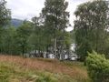
Image:20220718 093226.jpg|View to the southwest | Image:20220718 093226.jpg|View to the southwest | ||
Revision as of 18:06, 18 July 2022
| Mon 18 Jul 2022 in 58,5: 58.8752307, 5.8593802 geohashing.info google osm bing/os kml crox |
Location
A headland that juts out into Lutsivatnet.
Participants
Plans
Expedition
Tracklog
Photos

Lutsi @58.8752,5.8594
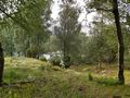
View to Storevågen
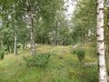
View to the northwest

View to the southwest
View to Forenessunda


Achievements