Difference between revisions of "2012-09-09 53 6"
imported>Shevek (Created page with "{{subst:Expedition|date = 2012-09-09 | lat = 53 | lon = 6}}") |
(→Achievements) |
||
| (6 intermediate revisions by 4 users not shown) | |||
| Line 1: | Line 1: | ||
| − | |||
| − | |||
| − | |||
| − | |||
| − | |||
| − | |||
| − | |||
| − | |||
| − | |||
| − | |||
{{meetup graticule | {{meetup graticule | ||
| lat=53 | | lat=53 | ||
| Line 15: | Line 5: | ||
}} | }} | ||
| − | |||
__NOTOC__ | __NOTOC__ | ||
== Location == | == Location == | ||
| − | + | The hash is in Tolbert, next to Leek, on a parking place. It's just off the highway, and very easy to reach. | |
== Participants == | == Participants == | ||
| − | + | * [[User:Shevek|Shevek]] | |
| − | + | * [[User:Gamma|Gamma]] | |
== Plans == | == Plans == | ||
| − | + | [[User:Shevek|Shevek]] and Gamma are going there by car. We'll leave from Groningen around 13:30, so we should arrive before 14:00. [[User:Shevek|Shevek]] is going for another drag-along, and this time also a no batteries achievement. It should be easy, there are more than enough orientation points on the satellite images. | |
== Expedition == | == Expedition == | ||
| − | + | Because of the no batteries attempt, [[User:Shevek|Shevek]] made a "map" before leaving. His printer was not working, so he had to draw it by hand. Because the route was so simple, there was no problem getting there. | |
| − | + | Once there, we made some pictures of us standing there. Meanwhile the person living there was sitting in his garden looking at us, obviously wondering what we were doing there. | |
| − | + | ||
| + | Because we didn't know if anyone else would be coming, we waited on a nearby bench in the sun. Nobody else showed up, though. So after a while, we decided to leave again. Before that, Shevek first talked to the local, though, who was just mounting his motorcycle. He seemed to understand the explanation, but didn't seem eager to collect his couch potato achievement. | ||
| + | |||
| + | On the way back, we decided to take the nicer road, avoiding the highway. For a moment, that seemed like a bad idea, because the road was marked as broken up, but it really wasn't, and we could just get home without a problem. | ||
== Photos == | == Photos == | ||
| − | |||
| − | |||
| − | |||
<gallery perrow="5"> | <gallery perrow="5"> | ||
| + | Image:2012-09-09_53_6-map.jpg | My comprehensible map | ||
| + | Image:2012-09-09_53_6-village.jpg | We're entering the village | ||
| + | Image:2012-09-09_53_6-hash1.jpg | I've arrived at the hash | ||
| + | Image:2012-09-09_53_6-hash2.jpg | I mean, we've arrived at the hash | ||
| + | Image:2012-09-09_53_6-hash3.jpg | We're still there | ||
| + | Image:2012-09-09_53_6-chill.jpg | That's enough, let's sit in the sun | ||
</gallery> | </gallery> | ||
== Achievements == | == Achievements == | ||
{{#vardefine:ribbonwidth|800px}} | {{#vardefine:ribbonwidth|800px}} | ||
| − | + | {{land geohash | latitude = 53 | longitude = 6 | date = 2012-09-09 | name = [[User:Shevek|Shevek]] and [[User:Gamma|Gamma]]| image = 2012-09-09_53_6-hash3.jpg}} | |
| + | {{No_batteries_geohash | latitude = 53 | longitude = 6 | date = 2012-09-09 | name = [[User:Shevek|Shevek]] and [[User:Gamma|Gamma]]| image = 2012-09-09_53_6-map.jpg}} | ||
| + | {{drag-along | latitude = 53 | longitude = 6 | date = 2012-09-09 | name = [[User:Shevek|Shevek]] | image = 2012-09-09_53_6-hash3.jpg}} | ||
| − | |||
| − | |||
| − | |||
| − | |||
| − | |||
| − | |||
| − | |||
| − | |||
| − | |||
| − | |||
| − | |||
[[Category:Expeditions]] | [[Category:Expeditions]] | ||
| − | |||
[[Category:Expeditions with photos]] | [[Category:Expeditions with photos]] | ||
| − | |||
| − | |||
| − | |||
| − | |||
| − | |||
[[Category:Coordinates reached]] | [[Category:Coordinates reached]] | ||
| − | + | [[Category:Shevek]] | |
| − | + | [[Category:Gamma]] | |
| − | + | {{location|NL|GR}} | |
| − | |||
| − | |||
| − | |||
| − | |||
| − | |||
| − | |||
| − | [[Category: | ||
| − | |||
| − | |||
| − | [[Category: | ||
| − | |||
| − | |||
| − | |||
| − | |||
| − | |||
Latest revision as of 10:26, 25 October 2022
| Sun 9 Sep 2012 in 53,6: 53.1708079, 6.3592374 geohashing.info google osm bing/os kml crox |
Location
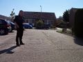
The hash is in Tolbert, next to Leek, on a parking place. It's just off the highway, and very easy to reach.
Participants
Plans
Shevek and Gamma are going there by car. We'll leave from Groningen around 13:30, so we should arrive before 14:00. Shevek is going for another drag-along, and this time also a no batteries achievement. It should be easy, there are more than enough orientation points on the satellite images.
Expedition
Because of the no batteries attempt, Shevek made a "map" before leaving. His printer was not working, so he had to draw it by hand. Because the route was so simple, there was no problem getting there.
Once there, we made some pictures of us standing there. Meanwhile the person living there was sitting in his garden looking at us, obviously wondering what we were doing there.
Because we didn't know if anyone else would be coming, we waited on a nearby bench in the sun. Nobody else showed up, though. So after a while, we decided to leave again. Before that, Shevek first talked to the local, though, who was just mounting his motorcycle. He seemed to understand the explanation, but didn't seem eager to collect his couch potato achievement.
On the way back, we decided to take the nicer road, avoiding the highway. For a moment, that seemed like a bad idea, because the road was marked as broken up, but it really wasn't, and we could just get home without a problem.
Photos
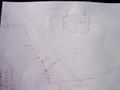
My comprehensible map

We're entering the village
I've arrived at the hash
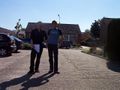
I mean, we've arrived at the hash
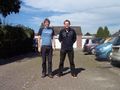
We're still there
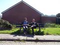
That's enough, let's sit in the sun


Achievements
Shevek and Gamma earned the Land geohash achievement
|
Shevek and Gamma earned the No Batteries Geohash Achievement
|
Shevek earned the Drag-along achievement
|