Difference between revisions of "2022-09-03 -37 144"
Felix Dance (talk | contribs) ([retro picture]At the hash) |
Felix Dance (talk | contribs) ([retro picture]John at the hash) |
||
| (9 intermediate revisions by 3 users not shown) | |||
| Line 1: | Line 1: | ||
| − | + | [[Image:{{{image|2022-09-03_-37_144_Felix Dance_1662281932425.jpg}}}|thumb|left]] | |
| − | + | {{meetup graticule | |
| − | |||
| − | |||
| − | |||
| − | |||
| − | |||
| − | |||
| lat=-37 | | lat=-37 | ||
| lon=144 | | lon=144 | ||
| date=2022-09-03 | | date=2022-09-03 | ||
| − | }} | + | }} |
== Location == | == Location == | ||
| − | + | It the old Melbourne sewerage outflow channel easement in Altona North. | |
== Participants == | == Participants == | ||
| − | + | * [[User:Felix Dance|Felix Dance]] | |
| − | + | * [[User:Stevage|Stevage]] | |
| + | * [[User:Johnwrw|John]] | ||
| − | == | + | == Expedition == |
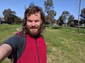
| − | + | === Expedition 1 - John === | |
| + | [[File:19a2d452-b331-4aa2-8dea-b5406ab77557.jpg|thumb|300px]] | ||
| + | John rode to the hash and stared straight into the sun to take this photo. | ||
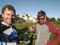
| − | == Expedition == | + | === Expedition 2 - Felix and Steve === |
| − | + | We met up at my (Felix's) place and rode down Moonee Ponds Creek, then along Dynon Rd to the Maribyrnong River. We took Yarraville and then the snarled, convoluted roadways interrupted by the enormous West Gate Tunnel Project, which has engorged roads and bike paths along its route like Tetsuo from Akira. | |
| + | |||
| + | Eventually, we found a backtracked way through a park and along some serviceable, industrial streets, south of the Footscray Cemetery. A few more residential streets and a hidden bike path cut between two house blocks and we were there. | ||
| + | |||
| + | Steve was kind enough to offer me a beer to celebrate. We sat in the fading sun for a quick chat and got back on our bikes for the return home. I took us an alternative route that followed my old way home from work (which used to be near there), passing through a Footscray street festival and the bustle of the Yarraville shops (not in that order). | ||
== Tracklog == | == Tracklog == | ||
| − | + | {{Tracklog | 20220903 150248 Altona North Geohash.gpx }} | |
== Photos == | == Photos == | ||
| − | |||
| − | |||
| − | |||
<gallery perrow="5"> | <gallery perrow="5"> | ||
| Line 37: | Line 35: | ||
Image:2022-09-03_-37_144_Felix Dance_1662281932425.jpg|At the hash | Image:2022-09-03_-37_144_Felix Dance_1662281932425.jpg|At the hash | ||
| + | |||
| + | Image:2022-09-03_-37_144_Felix Dance_1668255557706.jpg|Beers | ||
| + | |||
| + | Image:2022-09-03_-37_144_Felix Dance_1668255557759.jpg|John at the hash | ||
</gallery> | </gallery> | ||
== Achievements == | == Achievements == | ||
{{#vardefine:ribbonwidth|100%}} | {{#vardefine:ribbonwidth|100%}} | ||
| − | |||
| + | {{bicycle geohash | ||
| + | |||
| + | | latitude = -37 | ||
| + | | longitude = 144 | ||
| + | | date = 2022-08-31 | ||
| + | | name = [[User:Stevage|Stevage]], [[User:Felix Dance|Felix Dance]] and [[User:johnwrw|John]] | ||
| + | | distance = 33 kms | ||
| + | | bothways = true | ||
| + | | image = 2022-09-03_-37_144_Felix Dance_1662281932425.jpg | ||
| + | }} | ||
__NOTOC__ | __NOTOC__ | ||
| − | |||
| − | |||
| − | |||
| − | |||
| − | |||
| − | |||
| − | |||
| − | |||
| − | |||
| − | |||
| − | |||
| − | |||
| − | |||
| − | |||
[[Category:Expeditions]] | [[Category:Expeditions]] | ||
| − | |||
[[Category:Expeditions with photos]] | [[Category:Expeditions with photos]] | ||
| − | |||
| − | |||
| − | |||
| − | |||
| − | |||
[[Category:Coordinates reached]] | [[Category:Coordinates reached]] | ||
| − | + | {{location|AU|VIC|HB}} | |
| − | |||
| − | |||
| − | |||
| − | |||
| − | |||
| − | |||
| − | |||
| − | |||
| − | |||
| − | |||
| − | |||
| − | |||
| − | |||
| − | |||
| − | |||
| − | |||
| − | |||
Latest revision as of 12:19, 12 November 2022

| Sat 3 Sep 2022 in -37,144: -37.8220757, 144.8430522 geohashing.info google osm bing/os kml crox |
Location
It the old Melbourne sewerage outflow channel easement in Altona North.
Participants
Expedition
Expedition 1 - John

John rode to the hash and stared straight into the sun to take this photo.
Expedition 2 - Felix and Steve
We met up at my (Felix's) place and rode down Moonee Ponds Creek, then along Dynon Rd to the Maribyrnong River. We took Yarraville and then the snarled, convoluted roadways interrupted by the enormous West Gate Tunnel Project, which has engorged roads and bike paths along its route like Tetsuo from Akira.
Eventually, we found a backtracked way through a park and along some serviceable, industrial streets, south of the Footscray Cemetery. A few more residential streets and a hidden bike path cut between two house blocks and we were there.
Steve was kind enough to offer me a beer to celebrate. We sat in the fading sun for a quick chat and got back on our bikes for the return home. I took us an alternative route that followed my old way home from work (which used to be near there), passing through a Footscray street festival and the bustle of the Yarraville shops (not in that order).
Tracklog
Photos

GPS proof

At the hash
Beers
John at the hash


Achievements
Stevage, Felix Dance and John earned the Bicycle geohash achievement
|