Difference between revisions of "2022-11-12 -37 144"
Felix Dance (talk | contribs) ([live picture]Geohash! [https://openstreetmap.org/?mlat=-37.82829680&mlon=144.99676210&zoom=16 @-37.8283,144.9968]) |
m (Location) |
||
| (6 intermediate revisions by one other user not shown) | |||
| Line 1: | Line 1: | ||
| − | + | [[Image:{{{image|2022-11-12_-37_144_Felix Dance_1668255557896.jpg}}}|thumb|left]] | |
| − | + | {{meetup graticule | |
| − | |||
| − | |||
| − | |||
| − | |||
| − | |||
| − | |||
| lat=-37 | | lat=-37 | ||
| lon=144 | | lon=144 | ||
| date=2022-11-12 | | date=2022-11-12 | ||
| − | }} | + | }} |
| + | |||
== Location == | == Location == | ||
| − | + | Just inside a building at an office building in Cremorne, Melbourne. | |
== Participants == | == Participants == | ||
| − | + | *[[User:Felix Dance|Felix Dance]] | |
| − | + | *[[User:Lachie|Lachie]] | |
| + | *[[User:LauraG|Laura]] | ||
| + | |||
| + | == Expedition - Felix Dance == | ||
| + | From a distance, this geohash looked extremely gettable. Close to the city, on a weekend, right at a car park for an office building just off a public street. Easy! | ||
| − | + | Very soon after it was first identified, Lachie shared his Google location, seemingly demonstrating that he was heading to the hash right then and there. I followed him for a while as he approached the hash and then started going about my day. I vaguely thought I would make the effort later on if I had time. | |
| − | |||
| − | + | The day took me to a relaxed hang at my friends' place in Coburg, eating pizza and drinking beer on the back verandah. When it was time to leave at about 9:30pm I thought, now's the time. I announced to the group that I was heading not for home but for Richmond. But then, as I was preparing to leave, the rain set in. Nah, I thought. Lachie's already got this one anyway. Can't be arsed. | |
| − | + | ||
| + | At home, preparing for bed (I'd already got into my pajamas), our Bendigoing geohasher friend Tom started asking questions about whether or not this geohash had actually been got. The answer: no. Lachie had not been there despite his tease. | ||
| + | |||
| + | So this changed everything. I got into my riding-in-the-rain clothes, alerted the group and went to my road bike (no mucking around on slow bikes for this). | ||
| + | |||
| + | Lachie was at a party in Yarraville but was leaving soon and was keen to come. [[User:Johnwrw|John]] had a broken collarbone and made his apologies. | ||
| + | |||
| + | I rode through the rain down Moonee Ponds Creek where I met up with not only Lachie but Laura too, who'd been at the same party. We all rode on together through the Docklands, up the busy Yarra Southgate waterfront, heaving with washed-out and not appropriately dressed partyers. | ||
| + | |||
| + | Some wrangling got us through the city and into Richmond. A turn here past the long line of shivering Precinct Hotel hopefuls, a turn there around a booming house party, and we were at or near the hash. | ||
| + | |||
| + | We walked purposefully towards the hash-corner. No dice. Even after a few attempts the closest approach we could manage was 12m. From the satellite image it looked like we could theoretically get within 2m (and who knows how accurately the sat view represented the coordinates). But in the end we decided the point could not be reached. | ||
| + | |||
| + | We drank a beer each in the cold (mine was a whiskey red IPA - 7.5%), investigated possibly breaking into the un-leased office space (dubious) or climbing to the roof (doubly dubious), before finally parting ways with Laura and making our soggy way home, arriving just after midnight. | ||
== Tracklog == | == Tracklog == | ||
| − | + | {{ Tracklog | Geohash 2022-11-12 -37 144 GPX.gpx }} | |
== Photos == | == Photos == | ||
| − | |||
| − | |||
| − | |||
<gallery perrow="5"> | <gallery perrow="5"> | ||
Image:2022-11-12_-37_144_Felix Dance_1668255557896.jpg|Geohash! [https://openstreetmap.org/?mlat=-37.82829680&mlon=144.99676210&zoom=16 @-37.8283,144.9968] | Image:2022-11-12_-37_144_Felix Dance_1668255557896.jpg|Geohash! [https://openstreetmap.org/?mlat=-37.82829680&mlon=144.99676210&zoom=16 @-37.8283,144.9968] | ||
| + | |||
| + | Image:2022-11-12_-37_144_Felix Dance_1668255722517.jpg|Beers! [https://openstreetmap.org/?mlat=-37.82830670&mlon=144.99676910&zoom=16 @-37.8283,144.9968] | ||
| + | |||
| + | File:Geohash 2022-11-12 -37 144 Selfie1.jpeg|Laura selfie | ||
| + | File:Geohash 2022-11-12 -37 144 Selfie 2.jpeg|More inclusive Laura selfie | ||
| + | File:Geohash 2022-11-12 -37 144 GPS.jpg|GPS proof of not getting there | ||
| + | |||
</gallery> | </gallery> | ||
== Achievements == | == Achievements == | ||
{{#vardefine:ribbonwidth|100%}} | {{#vardefine:ribbonwidth|100%}} | ||
| − | + | {{bicycle geohash | |
| − | + | | latitude = -37 | |
| − | + | | longitude = 144 | |
| − | + | | date = 2022-11-12 | |
| − | [[ | + | | name = [[User:Felix Dance|Felix Dance]], [[User:Lachie|Lachie]] and [[User:LauraG|Laura]] |
| + | | distance = 25 kms | ||
| + | | bothways = true | ||
| + | | image = 2022-11-12_-37_144_Felix Dance_1668255557896.jpg | ||
| + | }} | ||
| − | + | {{Cliffs of Despair | |
| − | + | | latitude = -37 | |
| − | + | | longitude = 144 | |
| − | [[ | + | | date = 2022-11-12 |
| − | -- | + | | name = [[User:Felix Dance|Felix Dance]], [[User:Lachie|Lachie]] and [[User:LauraG|Laura]] |
| + | | terrain = office building wall | ||
| + | | image = 2022-11-12_-37_144_Felix Dance_1668255557896.jpg | ||
| + | }} | ||
| − | + | __NOTOC__ | |
| − | |||
| − | |||
[[Category:Expeditions]] | [[Category:Expeditions]] | ||
| − | |||
[[Category:Expeditions with photos]] | [[Category:Expeditions with photos]] | ||
| − | |||
| − | |||
| − | |||
| − | |||
| − | |||
| − | |||
| − | |||
| − | |||
| − | |||
[[Category:Coordinates not reached]] | [[Category:Coordinates not reached]] | ||
| − | |||
| − | |||
| − | |||
| − | |||
| − | |||
[[Category:Not reached - No public access]] | [[Category:Not reached - No public access]] | ||
| − | + | {{location|AU|VIC|YA}} | |
| − | |||
| − | |||
| − | |||
| − | |||
| − | |||
| − | |||
| − | |||
Latest revision as of 00:42, 14 November 2022

| Sat 12 Nov 2022 in -37,144: -37.8284529, 144.9963135 geohashing.info google osm bing/os kml crox |
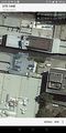
Location
Just inside a building at an office building in Cremorne, Melbourne.
Participants
Expedition - Felix Dance
From a distance, this geohash looked extremely gettable. Close to the city, on a weekend, right at a car park for an office building just off a public street. Easy!
Very soon after it was first identified, Lachie shared his Google location, seemingly demonstrating that he was heading to the hash right then and there. I followed him for a while as he approached the hash and then started going about my day. I vaguely thought I would make the effort later on if I had time.
The day took me to a relaxed hang at my friends' place in Coburg, eating pizza and drinking beer on the back verandah. When it was time to leave at about 9:30pm I thought, now's the time. I announced to the group that I was heading not for home but for Richmond. But then, as I was preparing to leave, the rain set in. Nah, I thought. Lachie's already got this one anyway. Can't be arsed.
At home, preparing for bed (I'd already got into my pajamas), our Bendigoing geohasher friend Tom started asking questions about whether or not this geohash had actually been got. The answer: no. Lachie had not been there despite his tease.
So this changed everything. I got into my riding-in-the-rain clothes, alerted the group and went to my road bike (no mucking around on slow bikes for this).
Lachie was at a party in Yarraville but was leaving soon and was keen to come. John had a broken collarbone and made his apologies.
I rode through the rain down Moonee Ponds Creek where I met up with not only Lachie but Laura too, who'd been at the same party. We all rode on together through the Docklands, up the busy Yarra Southgate waterfront, heaving with washed-out and not appropriately dressed partyers.
Some wrangling got us through the city and into Richmond. A turn here past the long line of shivering Precinct Hotel hopefuls, a turn there around a booming house party, and we were at or near the hash.
We walked purposefully towards the hash-corner. No dice. Even after a few attempts the closest approach we could manage was 12m. From the satellite image it looked like we could theoretically get within 2m (and who knows how accurately the sat view represented the coordinates). But in the end we decided the point could not be reached.
We drank a beer each in the cold (mine was a whiskey red IPA - 7.5%), investigated possibly breaking into the un-leased office space (dubious) or climbing to the roof (doubly dubious), before finally parting ways with Laura and making our soggy way home, arriving just after midnight.
Tracklog
Photos
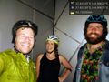
Geohash! @-37.8283,144.9968
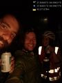
Beers! @-37.8283,144.9968
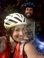
Laura selfie
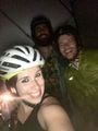
More inclusive Laura selfie
GPS proof of not getting there


Achievements
Felix Dance, Lachie and Laura earned the Bicycle geohash achievement
|
Felix Dance, Lachie and Laura earned the Cliffs of Despair consolation prize
|