Difference between revisions of "2022-12-26 58 5"
From Geohashing
(→Tracklog) |
(→Photos) |
||
| Line 39: | Line 39: | ||
Image:2022-12-26_58_5_Pica42_1672044559554.jpg|Eikeland [https://openstreetmap.org/?mlat=58.73414480&mlon=5.82434960&zoom=16 @58.7341,5.8243] | Image:2022-12-26_58_5_Pica42_1672044559554.jpg|Eikeland [https://openstreetmap.org/?mlat=58.73414480&mlon=5.82434960&zoom=16 @58.7341,5.8243] | ||
| − | |||
Image:2022-12-26_58_5_Pica42_1672044559560.jpg|Eikeland [https://openstreetmap.org/?mlat=58.73412150&mlon=5.82434900&zoom=16 @58.7341,5.8243] | Image:2022-12-26_58_5_Pica42_1672044559560.jpg|Eikeland [https://openstreetmap.org/?mlat=58.73412150&mlon=5.82434900&zoom=16 @58.7341,5.8243] | ||
| − | + | Image:20221226 084742.jpg|thumb|Photo taken in the direction of the hash. | |
</gallery> | </gallery> | ||
Revision as of 10:16, 26 December 2022
| Mon 26 Dec 2022 in 58,5: 58.7341209, 5.8243329 geohashing.info google osm bing/os kml crox |
Location
At the edge of a cultivated field/cow pasture at Eikeland, Time, Norway
Participants
Plans
Expedition
Tracklog
Photos
Eikeland @58.7341,5.8243

Eikeland @58.7341,5.8243
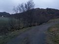
Photo taken in the direction of the hash.


Achievements