Difference between revisions of "2015-08-13 39 -89"
imported>Mystrsyko (Created page with "{{subst:Expedition |lat = 39 |lon = -89 |date = 2015-08-13 }}") |
m (Clearing out privacy concerns) |
||
| (3 intermediate revisions by 2 users not shown) | |||
| Line 1: | Line 1: | ||
| − | |||
| − | |||
| − | |||
| − | |||
| − | |||
| − | |||
| − | |||
| − | |||
| − | |||
| − | |||
{{meetup graticule | {{meetup graticule | ||
| lat=39 | | lat=39 | ||
| Line 15: | Line 5: | ||
}} | }} | ||
| − | |||
__NOTOC__ | __NOTOC__ | ||
== Location == | == Location == | ||
| − | + | Along Haugh Road west of Springfield. | |
== Participants == | == Participants == | ||
| − | + | *[[User:Mystrsyko|Mystrsyko]] | |
| − | + | *[[User:Dolphintreasure|Dolphintreasure]] | |
== Plans == | == Plans == | ||
| − | + | Bike out there at some point in the very near future | |
== Expedition == | == Expedition == | ||
| − | + | [[File:2015-08-13 39 -89 hashscots.jpg|260px|thumb|left|The Hashscot Army assembles!]] | |
| + | [[File:2015-08-13 39 -89 bikes.jpg|310px|thumb|right|Our bikes chose to sunbathe]] | ||
| + | [[File:2015-08-13 39 -89 hashscot army.jpg|260px|thumb|left|Many stupid grins!]] | ||
| + | This looked like another edge-of-the-road-next-to-a-corn-field hash, but when most of the land in your area is corn fields, you take what you can get. It appeared to be only 11 miles from home, and with both myself ([[User:Mystrsyko|Mystrsyko]]) and [[User:Dolphintreasure|Dolphintreasure]] off work for the day, we decided to ride our bikes to the hash together. | ||
| + | |||
| + | It was a bit hot in the sun, but not too hot, and the humidity was not that high either, so it made for a rather pleasant ride out to the point. We took the bike trail near our house for a few miles before plunging into the countryside on rarely used farm roads. In fact, other than hearing the Interstate highway a mile or so to our south, we didn't really encounter any traffic once we left the vicinity of the bike trail. | ||
| + | |||
| + | When we reached Haugh Road, we were in luck. Tall corn on both sides of a ''gravel'' road! This would almost surely mean there would be nobody around to bother us. Excitedly, I opened Geohash Droid as we made our final turn. | ||
| + | |||
| + | We pulled up near the point and found it quickly in the tall grass just outside the crop. We unloaded the hashscot army for some pictures and took some of the general area around the hash. Then the hashscots were packed back up in the bag and we took a moment to rest and have a drink. And then it happened. | ||
| + | |||
| + | A pickup truck appeared from the west, heading straight towards us. | ||
| + | |||
| + | As they slowed down, I prepared my not-at-all-thought-out excuse for why we were stopped on a gravel road in the middle of nowhere with our bicycles. "We were just following the GPS and had no idea why it took us this way," seemed plausible enough. But before I could decide, the truck driver decided for me by not bothering to stop at all and continued on their way. Whew, that was a close one. | ||
| − | + | Afterwards, we hopped back on the bikes for the trip home. Despite Dolphintreasure not being as strong a cyclist as myself, she managed the ride just fine and we both made it home happy (and exhausted) as could be. Then we went out for ice cream, because that's how you celebrate a great day of geohashing. | |
| − | |||
== Photos == | == Photos == | ||
| − | < | + | <gallery perrow="4"> |
| − | Image: | + | Image:2015-08-13 39 -89 grins.jpg|Taking a break |
| − | -- | + | Image:2015-08-13 39 -89 west.jpg|From the hash looking west |
| − | + | Image:2015-08-13 39 -89 east.jpg|From the hash looking east | |
| + | Image:2015-08-13 39 -89 proof.png|Proof! | ||
</gallery> | </gallery> | ||
== Achievements == | == Achievements == | ||
{{#vardefine:ribbonwidth|800px}} | {{#vardefine:ribbonwidth|800px}} | ||
| − | + | {{land geohash | |
| + | |||
| + | | latitude = 39 | ||
| + | | longitude = -89 | ||
| + | | date = 2015-08-13 | ||
| + | | name = Mystrsyko & Dolphintreasure | ||
| + | }} | ||
| − | + | {{bicycle geohash | |
| − | |||
| − | |||
| − | + | | latitude = 39 | |
| − | + | | longitude = -89 | |
| − | + | | date = 2015-08-13 | |
| − | + | | name = Mystrsyko & Dolphintreasure | |
| + | | distance = 21.9 miles | ||
| + | | bothways = true (optional) | ||
| + | }} | ||
| − | |||
| − | |||
[[Category:Expeditions]] | [[Category:Expeditions]] | ||
| − | |||
[[Category:Expeditions with photos]] | [[Category:Expeditions with photos]] | ||
| − | |||
| − | |||
| − | |||
| − | |||
| − | |||
[[Category:Coordinates reached]] | [[Category:Coordinates reached]] | ||
| − | + | {{location|US|IL|SM}} | |
| − | |||
| − | |||
| − | |||
| − | |||
| − | |||
| − | |||
| − | |||
| − | |||
| − | |||
| − | |||
| − | |||
| − | |||
| − | |||
| − | |||
| − | |||
| − | |||
| − | |||
Latest revision as of 00:56, 31 December 2022
| Thu 13 Aug 2015 in 39,-89: 39.7630438, -89.8320610 geohashing.info google osm bing/os kml crox |
Location
Along Haugh Road west of Springfield.
Participants
Plans
Bike out there at some point in the very near future
Expedition


This looked like another edge-of-the-road-next-to-a-corn-field hash, but when most of the land in your area is corn fields, you take what you can get. It appeared to be only 11 miles from home, and with both myself (Mystrsyko) and Dolphintreasure off work for the day, we decided to ride our bikes to the hash together.
It was a bit hot in the sun, but not too hot, and the humidity was not that high either, so it made for a rather pleasant ride out to the point. We took the bike trail near our house for a few miles before plunging into the countryside on rarely used farm roads. In fact, other than hearing the Interstate highway a mile or so to our south, we didn't really encounter any traffic once we left the vicinity of the bike trail.
When we reached Haugh Road, we were in luck. Tall corn on both sides of a gravel road! This would almost surely mean there would be nobody around to bother us. Excitedly, I opened Geohash Droid as we made our final turn.
We pulled up near the point and found it quickly in the tall grass just outside the crop. We unloaded the hashscot army for some pictures and took some of the general area around the hash. Then the hashscots were packed back up in the bag and we took a moment to rest and have a drink. And then it happened.
A pickup truck appeared from the west, heading straight towards us.
As they slowed down, I prepared my not-at-all-thought-out excuse for why we were stopped on a gravel road in the middle of nowhere with our bicycles. "We were just following the GPS and had no idea why it took us this way," seemed plausible enough. But before I could decide, the truck driver decided for me by not bothering to stop at all and continued on their way. Whew, that was a close one.
Afterwards, we hopped back on the bikes for the trip home. Despite Dolphintreasure not being as strong a cyclist as myself, she managed the ride just fine and we both made it home happy (and exhausted) as could be. Then we went out for ice cream, because that's how you celebrate a great day of geohashing.
Photos

Taking a break
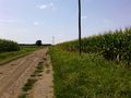
From the hash looking west
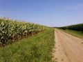
From the hash looking east
Proof!


Achievements
Mystrsyko & Dolphintreasure earned the Land geohash achievement
|
Mystrsyko & Dolphintreasure earned the Bicycle geohash achievement
|