Difference between revisions of "2023-02-19 30 -97"
Sporksmith (talk | contribs) (An expedition message sent via Geohash Droid for Android.) |
Sporksmith (talk | contribs) (→Photos: additional photos) |
||
| (4 intermediate revisions by 3 users not shown) | |||
| Line 1: | Line 1: | ||
| − | + | [[Image:{{{image|2023-02-19 30 -97 sporksmith-juggling.jpg}}}|thumb|left]] | |
| − | + | {{meetup graticule | |
| − | |||
| − | |||
| − | |||
| − | |||
| − | |||
| − | |||
| lat=30 | | lat=30 | ||
| lon=-97 | | lon=-97 | ||
| date=2023-02-19 | | date=2023-02-19 | ||
| − | }} | + | }} |
== Location == | == Location == | ||
| − | + | Whitestone Preserve Trail | |
== Participants == | == Participants == | ||
| − | + | [[User:Sporksmith|Sporksmith]] ([[User talk:Sporksmith|talk]]) | |
| − | + | ||
| + | == Expedition == | ||
| + | |||
| + | The expedition went pretty smoothly! It was beautiful weather, and about 15 miles each way by bicycle. | ||
| − | + | One minor snag on the way there was that google maps's bicycle navigation took me on a "shortcut" through a nature preserve with rough unmarked trails, some of which were blocked with downed branches from a recent ice storm. I ended up doing some backtracking and crawling through brush to get around blockages. | |
| − | |||
| − | + | The hashpoint was at a playground, which was also a trailhead for another small nature preserve. After getting a video of myself juggling for the circus achievement, I hiked the short trail. There were several marked caves along the trail with plaques describing them. The caves themselves were guarded by fences and metal grates. | |
| − | |||
== Tracklog == | == Tracklog == | ||
| − | + | ||
| + | {{ tracklog | workout-2023-02-19_08-24-Geo_hash_to.gpx }} | ||
== Photos == | == Photos == | ||
| − | |||
| − | |||
| − | |||
<gallery perrow="5"> | <gallery perrow="5"> | ||
| + | Image:2023-02-19_30_-97_sporksmith_1676822399431.jpg|Made it! [https://openstreetmap.org/?mlat=30.49640278&mlon=-97.84461389&zoom=16 @30.4964,-97.8446] | ||
| + | Image:2023-02-19 30 -97 sporksmith-juggling.jpg|sporksmith juggling | ||
| + | Image:2023-02-19 30 -97 sporksmith-shortcut.jpg|A "shortcut" to the hashpoint | ||
| + | Image:PXL_20230219_162815052.MP.jpg|Whitestone Preserve Trail head, a few meters from the hash point | ||
| + | Image:PXL_20230219_161933919.jpg|Pearl Harbor Cave plaque | ||
| + | Image:PXL_20230219_161929753.jpg|Pearl Harbor Cave plaque closeup | ||
| + | Image:PXL_20230219_162002110.jpg|Pearl Harbor Cave entrance | ||
| + | Image:PXL_20230219_162037304.jpg|MLK tribute | ||
| + | Image:PXL_20230219_162138359.jpg|Honeycomb Cave plaque | ||
| + | Image:PXL_20230219_162141538.jpg|Honeycomb Cave plaque closeup | ||
| + | Image:PXL_20230219_162210685.jpg|Honeycomb Cave entrance | ||
| + | Image:PXL_20230219_162403763.jpg|Whitestone Cave plaque | ||
| + | Image:PXL_20230219_162408244.jpg|Whitestone Cave plaque closeup | ||
| + | Image:PXL_20230219_162437488.jpg|Whitestone Cave entrance | ||
| + | Image:PXL_20230219_162653406.jpg|Bad Air Fissure sign | ||
</gallery> | </gallery> | ||
| + | |||
| + | == Video == | ||
| + | <youtube>https://www.youtube.com/watch?v=krc_gn5ajxI</youtube> | ||
| + | [https://www.youtube.com/shorts/krc_gn5ajxI sporksmith juggling] | ||
== Achievements == | == Achievements == | ||
{{#vardefine:ribbonwidth|100%}} | {{#vardefine:ribbonwidth|100%}} | ||
| − | |||
| + | {{land geohash | ||
| + | | latitude = 30 | ||
| + | | longitude = -97 | ||
| + | | date = 2023-02-19 | ||
| + | | name = sporksmith | ||
| + | }} | ||
| + | {{bicycle geohash | ||
| + | | latitude = 30 | ||
| + | | longitude = -97 | ||
| + | | date = 2023-02-19 | ||
| + | | name = sporksmith | ||
| + | | distance = 30 miles | ||
| + | | bothways = true | ||
| + | }} | ||
| + | {{Circus_geohash | ||
| + | | latitude = 30 | ||
| + | | longitude = -97 | ||
| + | | date = 2023-02-19 | ||
| + | | name = sporksmith | ||
| + | | performance = juggling | ||
| + | }} | ||
__NOTOC__ | __NOTOC__ | ||
| − | |||
| − | |||
| − | |||
| − | |||
| − | |||
| − | |||
| − | |||
| − | |||
| − | |||
| − | |||
| − | |||
| − | |||
| − | |||
| − | |||
[[Category:Expeditions]] | [[Category:Expeditions]] | ||
| − | |||
[[Category:Expeditions with photos]] | [[Category:Expeditions with photos]] | ||
[[Category:Expeditions with videos]] | [[Category:Expeditions with videos]] | ||
| − | |||
| − | |||
| − | |||
| − | |||
[[Category:Coordinates reached]] | [[Category:Coordinates reached]] | ||
| − | + | {{location|US|TX|WM}} | |
| − | |||
| − | |||
| − | |||
| − | |||
| − | |||
| − | |||
| − | |||
| − | |||
| − | |||
| − | |||
| − | |||
| − | |||
| − | |||
| − | |||
| − | |||
| − | |||
| − | |||
Latest revision as of 14:27, 20 February 2023

| Sun 19 Feb 2023 in 30,-97: 30.4963914, -97.8446142 geohashing.info google osm bing/os kml crox |
Location
Whitestone Preserve Trail
Participants
Expedition
The expedition went pretty smoothly! It was beautiful weather, and about 15 miles each way by bicycle.
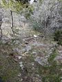
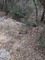
One minor snag on the way there was that google maps's bicycle navigation took me on a "shortcut" through a nature preserve with rough unmarked trails, some of which were blocked with downed branches from a recent ice storm. I ended up doing some backtracking and crawling through brush to get around blockages.
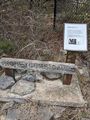
The hashpoint was at a playground, which was also a trailhead for another small nature preserve. After getting a video of myself juggling for the circus achievement, I hiked the short trail. There were several marked caves along the trail with plaques describing them. The caves themselves were guarded by fences and metal grates.
Tracklog
Photos

Made it! @30.4964,-97.8446
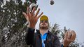
sporksmith juggling
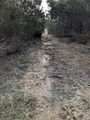
A "shortcut" to the hashpoint
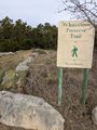
Whitestone Preserve Trail head, a few meters from the hash point
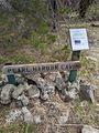
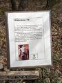
Pearl Harbor Cave plaque
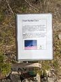
Pearl Harbor Cave plaque closeup
Pearl Harbor Cave entrance
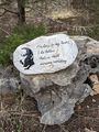
MLK tribute
Honeycomb Cave plaque
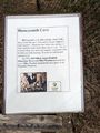
Honeycomb Cave plaque closeup
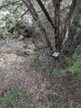
Honeycomb Cave entrance
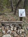
Whitestone Cave plaque
Whitestone Cave plaque closeup
Whitestone Cave entrance
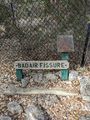
Bad Air Fissure sign


Video
Achievements
sporksmith earned the Land geohash achievement
|
sporksmith earned the Bicycle geohash achievement
|
sporksmith earned the Circus Geohash Achievement
|