Difference between revisions of "2023-02-23 58 5"
From Geohashing
(→Tracklog) |
(→Photos) |
||
| Line 40: | Line 40: | ||
Image:2023-02-23_58_5_Pica42_1677149887832.jpg|Øykjafjellet [https://openstreetmap.org/?mlat=58.86035410&mlon=5.88710800&zoom=16 @58.8604,5.8871] | Image:2023-02-23_58_5_Pica42_1677149887832.jpg|Øykjafjellet [https://openstreetmap.org/?mlat=58.86035410&mlon=5.88710800&zoom=16 @58.8604,5.8871] | ||
| − | + | Image:20230223 58-5- This is the path immediately after the start of the trip.jpg|thumb|This is the path immediately after the start of the trip. | |
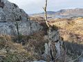
| − | + | Image:20230223 58 5-Part of the path.jpg|thumb|Part of the path. | |
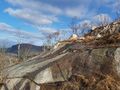
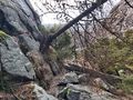
| − | + | Image:20230223 The path went on the rock shelf to the left of the picture..jpg|thumb|The path went on the rock shelf to the left of the picture. | |
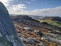
| + | Image:20230223 58 5-W.jpg|thumb|View to the west. | ||
| + | Image:20230223 S.jpg|thumb|View to the south. | ||
| + | Image:20230223 Part of the path.jpg|thumb|Part of the path. | ||
</gallery> | </gallery> | ||
Revision as of 14:45, 23 February 2023
| Thu 23 Feb 2023 in 58,5: 58.8603301, 5.8871427 geohashing.info google osm bing/os kml crox |

Location
Øykjafjellet, Noredalen, Sandnes, Norway
Participants
Plans
Expedition
Tracklog
Photos

Øykjafjellet @58.8604,5.8871
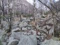
This is the path immediately after the start of the trip.
Part of the path.
The path went on the rock shelf to the left of the picture.
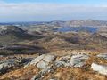
View to the west.
View to the south.
Part of the path.


Achievements