Difference between revisions of "2021-07-07 53 9"
(expedition report) |
(→Photos) |
||
| Line 13: | Line 13: | ||
==Photos== | ==Photos== | ||
| − | + | [[File:2021-07-07 53 9 1.jpg|750px|Panorama above cover]] | |
| + | [[File:2021-07-07 53 9 2.jpg|750px|Panorama below cover]] | ||
| + | <gallery> | ||
| + | File:2021-07-07 53 9 c.jpg | coords | ||
| + | File:2021-07-07 53 9 p.jpg | proof | ||
| + | File:2021-07-07 53 9 3.jpg | from the ground | ||
| + | File:2021-07-07 53 9 5.jpg | made it! | ||
| + | File:2021-07-07 53 9 6.jpg | the hash | ||
| + | File:2021-07-07 53 9 7.jpg | short visual range in here | ||
| + | File:2021-07-07 53 9 8.jpg | they also come in smaller | ||
| + | </gallery> | ||
==Achievements== | ==Achievements== | ||
Latest revision as of 22:44, 3 March 2023
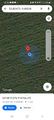
| Wed 7 Jul 2021 in 53,9: 53.8047330, 9.6850833 geohashing.info google osm bing/os kml crox |
Location
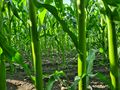
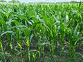
on a maize field in Klein Offenseth-Sparrieshoop, Schleswig-Holstein
Participants
Expedition
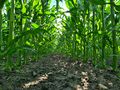
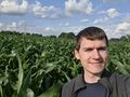
Another sub-2h expedition (narrowly, due to lucky train times), so I had to go for it. When I wanted to leave, I checked the train schedule and noticed I had just missed my opportunity a minute ago, meaning I had to wait another hour. I did, then took the train to Sparrieshoop and cycled 3.4 km to the hashpoint. It lay 48 m onto a large field of chest-high maize. Unfortunately, from the nearest path, I had to walk perpendicular to the rows of maize and needed to find gaps between the stems or spread them apart, but fortunately, the rows were so far apart that I could easily avoid damaging any of the plants. I found the coordinates, took photos and walked back. I cycled a different route back to the station, where I had to to wait 10 minutes for the train to Henstedt-Ulzburg.
My 98th geohash – only two (or one, depending on if you count the Globalhash) expeditions until 100!
Photos


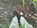
coords
proof
from the ground
made it!
the hash
short visual range in here
they also come in smaller


Achievements
Land geohash, Bicycle geohash, Public transport geohash