Difference between revisions of "2023-03-07 58 5"
From Geohashing
(→Photos) |
(→Photos) |
||
| Line 42: | Line 42: | ||
Image:20230307 58-5-NW.jpg|thumb|View to the northwest. | Image:20230307 58-5-NW.jpg|thumb|View to the northwest. | ||
Image:20230307 58-5-SW.jpg|thumb|View to the southwest. | Image:20230307 58-5-SW.jpg|thumb|View to the southwest. | ||
| − | + | Image:20230307 58-5-E.jpg|thumb|View to the east. | |
</gallery> | </gallery> | ||
Revision as of 15:43, 7 March 2023
| Tue 7 Mar 2023 in 58,5: 58.6335445, 5.9437915 geohashing.info google osm bing/os kml crox |
Location
About 200 meters from the road up to the top at Urdalsnipa, Bjerkreim, Norway.
Participants
Plans
Expedition
Tracklog
Photos
Urdalsnipa @58.6336,5.9438
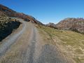
The road up towards the hash.
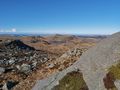
View to the northwest.
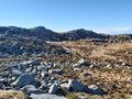
View to the southwest.
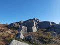
View to the east.


Achievements