Difference between revisions of "2023-03-13 47 8"
Globescorer (talk | contribs) |
m (Categories) |
||
| (2 intermediate revisions by 2 users not shown) | |||
| Line 1: | Line 1: | ||
{{meetup graticule|date=2023-03-13|lat=47|lon=8}} | {{meetup graticule|date=2023-03-13|lat=47|lon=8}} | ||
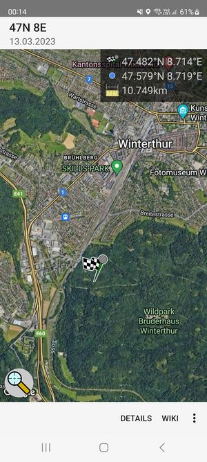
| − | + | [[File:2023-03-13 47 8 Final zoomed out.jpg|300px]] | |
==Location== | ==Location== | ||
The Geohash is located in the forest of the Eschenberg near the town Winterthur. | The Geohash is located in the forest of the Eschenberg near the town Winterthur. | ||
| − | |||
| − | |||
==Participants== | ==Participants== | ||
| Line 29: | Line 27: | ||
File:2023-03-13 47 8 east.jpg |east | File:2023-03-13 47 8 east.jpg |east | ||
</gallery> | </gallery> | ||
| + | |||
| + | [[Category:Expeditions]] | ||
| + | [[Category:Expeditions with photos]] | ||
| + | [[Category:Coordinates reached]] | ||
| + | {{location|CH|ZH}} | ||
Latest revision as of 20:15, 13 March 2023
| Mon 13 Mar 2023 in 47,8: 47.4819404, 8.7144761 geohashing.info google osm bing/os kml crox |
Contents
Location
The Geohash is located in the forest of the Eschenberg near the town Winterthur.
Participants
Expedition
from the coordinates published this weekend, today's was the only one i could tackle. Before work, i drove a detour as close to the geohash as possible. I was already familiar with the area, as there is a well-known recreation area nearby. so i parked my car somewhere nearby and made my way through the forest...
Most of the time not on paved paths I came to a children's forest playground. There i could also use a small improvised wooden bridge. Soon I reached the coordinates. The GPS here in the forest was not very good and i ran to the left and to the right to hit the target to some extent... The ground was overgrown with thorns. So I took my pictures and proofs and left the place how I came.
Because of the detour and the traffic i was a bit late for work. But what don't you do all for your hobby! :-)


