Difference between revisions of "2023-04-15 47 7"
From Geohashing
(success) |
(tinkering) |
||
| (3 intermediate revisions by the same user not shown) | |||
| Line 1: | Line 1: | ||
| − | |||
| − | [[Image:{{{image| | + | [[Image:{{{image|2023-04-15 47 7 this is the spot.jpg}}}|thumb|left]] |
| − | + | {{meetup graticule | |
| − | |||
| − | |||
| − | |||
| − | |||
| lat=47 | | lat=47 | ||
| lon=7 | | lon=7 | ||
| date=2023-04-15 | | date=2023-04-15 | ||
| − | }} | + | }} |
== Location == | == Location == | ||
In the woods between Schnottwil and Büren an der Aare | In the woods between Schnottwil and Büren an der Aare | ||
| Line 22: | Line 17: | ||
== Expedition == | == Expedition == | ||
| − | |||
| − | |||
*Got there! -- [[User:Uschoen|Uschoen]] ([[User talk:Uschoen|talk]]) [https://openstreetmap.org/?mlat=47.12508330&mlon=7.38069700&zoom=16 @47.1251,7.3807] 17:04, 15 April 2023 (GMT+02:00) | *Got there! -- [[User:Uschoen|Uschoen]] ([[User talk:Uschoen|talk]]) [https://openstreetmap.org/?mlat=47.12508330&mlon=7.38069700&zoom=16 @47.1251,7.3807] 17:04, 15 April 2023 (GMT+02:00) | ||
| − | *The start of the expedition got a bit delayed because of ride-sharing issues. But atfer that, everything went smoothly. Even the not so fantastic weather did not stand in the way too much. First geohash acheived! | + | *The start of the expedition got a bit delayed because of ride-sharing issues. But atfer that, everything went smoothly. Even the not so fantastic weather did not stand in the way too much. First geohash acheived! [[User:Uschoen|Uschoen]] ([[User talk:Uschoen|talk]]) |
| − | |||
| − | |||
| − | |||
== Photos == | == Photos == | ||
| − | |||
| − | |||
| − | |||
<gallery perrow="5"> | <gallery perrow="5"> | ||
| + | File:2023-04-15 47 7 this is the spot.jpg | This is the spot, a mix of bushes and stinging nettle | ||
| + | File:2023-04-15 47 7 there will be signs.jpg | The path to the destination had a name. | ||
| + | File:2023-04-15 47 7 Geohash Droid.jpg | The app said I was really there. | ||
</gallery> | </gallery> | ||
| Line 43: | Line 33: | ||
__NOTOC__ | __NOTOC__ | ||
| − | <!-- =============== USEFUL CATEGORIES FOLLOW ================ | + | <!-- =============== USEFUL CATEGORIES FOLLOW ================ --> |
| − | |||
| − | |||
| − | |||
| − | |||
| − | |||
| − | |||
| − | |||
| − | |||
| − | |||
[[Category:Expeditions]] | [[Category:Expeditions]] | ||
| − | |||
[[Category:Expeditions with photos]] | [[Category:Expeditions with photos]] | ||
| − | |||
| − | |||
| − | |||
| − | |||
[[Category:Coordinates reached]] | [[Category:Coordinates reached]] | ||
| + | {{location|CH|BE}} | ||
Latest revision as of 12:59, 16 April 2023

| Sat 15 Apr 2023 in 47,7: 47.1250593, 7.3806833 geohashing.info google osm bing/os kml crox |
Location
In the woods between Schnottwil and Büren an der Aare
Participants
Plans
Trying my first expedition this afternoon. Let's see how this goes.
Expedition
- Got there! -- Uschoen (talk) @47.1251,7.3807 17:04, 15 April 2023 (GMT+02:00)
- The start of the expedition got a bit delayed because of ride-sharing issues. But atfer that, everything went smoothly. Even the not so fantastic weather did not stand in the way too much. First geohash acheived! Uschoen (talk)
Photos
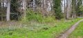
This is the spot, a mix of bushes and stinging nettle
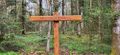
The path to the destination had a name.
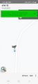
The app said I was really there.


Achievements
Uschoen earned the Land geohash achievement
|