Difference between revisions of "2023-06-08 30 -97"
Enjoythecode (talk | contribs) ([live picture](oops, other photo had the wrong location... posting using my current location) [https://openstreetmap.org/?mlat=30.31036350&mlon=-97.78699940&zoom=16 @30.3104,-97.7870]) |
Enjoythecode (talk | contribs) (write-up expedition) |
||
| Line 1: | Line 1: | ||
<!-- If you did not specify these parameters in the template, please substitute appropriate values for IMAGE, LAT, LON, and DATE (YYYY-MM-DD format) | <!-- If you did not specify these parameters in the template, please substitute appropriate values for IMAGE, LAT, LON, and DATE (YYYY-MM-DD format) | ||
| − | + | And DON'T FORGET to add your expedition and the best photo you took to the gallery on the Main Page! We'd love to read your report, but that means we first have to discover it! :) | |
| − | |||
| − | |||
| − | |||
| − | |||
-->{{meetup graticule | -->{{meetup graticule | ||
| lat=30 | | lat=30 | ||
| lon=-97 | | lon=-97 | ||
| date=2023-06-08 | | date=2023-06-08 | ||
| − | }} | + | }} |
== Location == | == Location == | ||
| + | On a public road (Bennedict Lane) within the suburbs of West Austin. | ||
<!-- where you've surveyed the hash to be --> | <!-- where you've surveyed the hash to be --> | ||
== Participants == | == Participants == | ||
| − | + | [[User:Enjoythecode|enjoythecode]] ([[User talk:Enjoythecode|talk]]) + drag-along Ebru (my mom, a first time geohasher!) | |
| − | |||
== Plans == | == Plans == | ||
| − | + | Straightforward: drive there, and then enjoy a few bites at a nearby cafe overlooking Lake Austin :) | |
== Expedition == | == Expedition == | ||
| − | + | First step was to convince my mother to drive me to the geohash, a concept she learned about on our way to this hash :) | |
| + | |||
| + | Getting there was pretty straightforward, just a simple drive on the 360 (notably, it is the first highway I have seen in my life with traffic lights frequently stopping traffic...). | ||
| + | |||
| + | We got there around 7pm, and we took advantage of the setting sun to take some photos and explore around. Notable finds included: | ||
| + | 1. The most sheltered outdoors mailbox that I have seen in my life | ||
| + | 2. My first sighting of deers, and not only that, but deers *in a residential area*! | ||
| − | + | Then, we reaped the rewards of our hard-earned driving by visiting a nearby cafe and having something to eat. The live music was pretty nice, and the free edition of "The Austin Chronicles" is our keepsake from this expedition :) | |
| − | |||
== Photos == | == Photos == | ||
| Line 32: | Line 33: | ||
Image:2020-##-## ## ## Alpha.jpg | Witty Comment | Image:2020-##-## ## ## Alpha.jpg | Witty Comment | ||
--> | --> | ||
| + | (more to come very soon) | ||
<gallery perrow="5"> | <gallery perrow="5"> | ||
| − | Image:2023-06-08_30_- | + | Image:2023-06-08_30_-97_enjoythecode_1686270531459.jpg|Made it to this (easily drivable!) geohash, my first in Austin! [https://openstreetmap.org/?mlat=30.31036350&mlon=-97.78699940&zoom=16 @30.3104,-97.7870] |
| + | |||
| + | Image:20230608_30_-97_dragAlong.jpeg|My drag-along, Ebru! | ||
| + | |||
| + | Image:20230608_30_-97_shelteredOutdoorsMailbox.jpg|This mailbox had an overly nice shelter for itself! | ||
| + | |||
| + | Image:20230608_30_-97_zoomedInDeers.jpg|Overly-zoomed in dears to not spook them! | ||
| + | |||
| + | Image:20230608_30_-97_sunsetAtNearbyCafeOverlookingLakeAustin.jpg| Nice sunset shot overlooking Lake Austin from nearby cafe. | ||
| − | |||
</gallery> | </gallery> | ||
| Line 42: | Line 51: | ||
{{#vardefine:ribbonwidth|100%}} | {{#vardefine:ribbonwidth|100%}} | ||
<!-- Add any achievement ribbons you earned below, or remove this section --> | <!-- Add any achievement ribbons you earned below, or remove this section --> | ||
| + | {{drag-along | ||
| + | | latitude = 30 | ||
| + | | longitude = -97 | ||
| + | | date = 2022-06-08 | ||
| + | | partner = mother, Ebru | ||
| + | | name = Widdershins | ||
| + | | image = Widder.jpg | ||
| − | |||
| − | |||
| − | |||
| − | |||
| − | |||
| − | |||
| − | |||
| − | |||
| − | |||
| − | |||
| − | |||
| − | |||
| − | |||
| − | |||
| − | |||
[[Category:Expeditions]] | [[Category:Expeditions]] | ||
| − | |||
[[Category:Expeditions with photos]] | [[Category:Expeditions with photos]] | ||
| − | |||
| − | |||
| − | |||
| − | |||
| − | |||
[[Category:Coordinates reached]] | [[Category:Coordinates reached]] | ||
| − | |||
| − | |||
| − | |||
| − | |||
| − | |||
| − | |||
| − | |||
| − | |||
| − | |||
| − | |||
| − | |||
| − | |||
| − | |||
| − | |||
| − | |||
| − | |||
| − | |||
| − | |||
Revision as of 06:04, 9 June 2023
| Thu 8 Jun 2023 in 30,-97: 30.3103555, -97.7869681 geohashing.info google osm bing/os kml crox |
Location
On a public road (Bennedict Lane) within the suburbs of West Austin.
Participants
enjoythecode (talk) + drag-along Ebru (my mom, a first time geohasher!)
Plans
Straightforward: drive there, and then enjoy a few bites at a nearby cafe overlooking Lake Austin :)
Expedition
First step was to convince my mother to drive me to the geohash, a concept she learned about on our way to this hash :)
Getting there was pretty straightforward, just a simple drive on the 360 (notably, it is the first highway I have seen in my life with traffic lights frequently stopping traffic...).
We got there around 7pm, and we took advantage of the setting sun to take some photos and explore around. Notable finds included: 1. The most sheltered outdoors mailbox that I have seen in my life 2. My first sighting of deers, and not only that, but deers *in a residential area*!
Then, we reaped the rewards of our hard-earned driving by visiting a nearby cafe and having something to eat. The live music was pretty nice, and the free edition of "The Austin Chronicles" is our keepsake from this expedition :)
Photos
(more to come very soon)

Made it to this (easily drivable!) geohash, my first in Austin! @30.3104,-97.7870

My drag-along, Ebru!
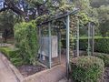
This mailbox had an overly nice shelter for itself!
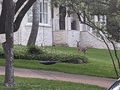
Overly-zoomed in dears to not spook them!
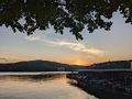
Nice sunset shot overlooking Lake Austin from nearby cafe.


Achievements
{{drag-along | latitude = 30 | longitude = -97 | date = 2022-06-08 | partner = mother, Ebru | name = Widdershins | image = Widder.jpg