Difference between revisions of "2019-04-09 51 13"
From Geohashing
imported>Danatar (Report!) |
(→tracklog) |
||
| (One intermediate revision by one other user not shown) | |||
| Line 34: | Line 34: | ||
===tracklog=== | ===tracklog=== | ||
| − | + | {{tracklog | 2019-04-09 51 13-triton.gpx}} | |
[[Category:Expeditions]] | [[Category:Expeditions]] | ||
| Line 40: | Line 40: | ||
[[Category:Coordinates reached]] | [[Category:Coordinates reached]] | ||
[[Category:Danatar]] | [[Category:Danatar]] | ||
| + | {{location|DE|SN|DD}} | ||
Latest revision as of 11:15, 17 August 2023
| Tue 9 Apr 2019 in Dresden: 51.0754999, 13.6919677 geohashing.info google osm bing/os kml crox |
Location
Today's location is in the Elbe floodway in Dresden-Mikten.
Country: Germany; state: Sachsen (Saxony, EU:DE:SN); district: Dresden; Ortsamt: Pieschen; statistischer Stadtteil: Mikten
Expedition
Danatar
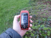
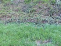
On my way to a orchestra rehearsal I decided to visit this hashpoint. I started directly from work, cycling to the Elbe first then following the bicycle track along the river. At Mikten I reached the start of the floodway and followed that. Not much later I was at the hashpoint. A short hashdance brought me to the spot which was directly at the edge between the flat floodway meadow and the very thorny brambles (probably blackberries) on the slope along the floodway. I took some pictures, then continued to the rehearsal.
In total I cycled 12.5 km.
|
tracklog


