Difference between revisions of "2019-04-12 50 8"
imported>Danatar (Planning) |
(→tracklog) |
||
| (3 intermediate revisions by 2 users not shown) | |||
| Line 2: | Line 2: | ||
| lat=50 | | lat=50 | ||
| lon=8 | | lon=8 | ||
| − | | date=2019-04- | + | | date=2019-04-12 |
| graticule_name=Frankfurt/M | | graticule_name=Frankfurt/M | ||
| graticule_link=Frankfurt am Main, Germany | | graticule_link=Frankfurt am Main, Germany | ||
| Line 16: | Line 16: | ||
=== Planning === | === Planning === | ||
It's the first day of my vacations (I hope to visit hashpoints near London, UK; Edinburgh, UK and Dublin, IR) and I'll drive from 51 13 to my parents in 49 8. The hashpoint is only a tiny detour from the Autobahn and it's right at the side of a road. As long as there are no huge construction sites, road blocks or problems with my car or my health during the drive, I should finally conquer the 50 8 graticule which has eluded me for [[2008-12-14 50 8|more than 10 years]]! | It's the first day of my vacations (I hope to visit hashpoints near London, UK; Edinburgh, UK and Dublin, IR) and I'll drive from 51 13 to my parents in 49 8. The hashpoint is only a tiny detour from the Autobahn and it's right at the side of a road. As long as there are no huge construction sites, road blocks or problems with my car or my health during the drive, I should finally conquer the 50 8 graticule which has eluded me for [[2008-12-14 50 8|more than 10 years]]! | ||
| − | + | ||
=== Expedition=== | === Expedition=== | ||
| − | + | The drive from Dresden started out fine and I made good progress until I reached the Autobahn interchange at Bad Hersfeld. There the combination of the interchange between three major Autobahnen (A4, A5, A7) and road construction works with only one usable lane created a large traffic jam. In the end it took me about one hour to pass the interchange. Later I left the Autobahn at the Grünberg exit, then I drove through Grünberg until I reached the small road that led to Göbelnrod. Following that I was soon near the hashpoint. As I didn't want to stop in the middle of the road I used the next field track and parked the car on the other side of the railroad in order not to block the track. When I got out a car came down the track and the driver told me not to leave the car for too long as within 15 minutes a farmer would come along with a large machine. I answered that I would only take a few minutes. Then I walked along the road to the hashpoint. When I reached the spot it was on the meadow just on the other side of the drainage ditch and I had no problems finding the exact coordinates. All the time I was looking out towards the direction the farmer was announced to come from so that I could hurry back to my car when I saw him. For that reason I quickly took pictures and then walked back to the car. Without any farmer arriving I was able to continue my journey. I drove via Göbelnrod to Reiskirchen and went back on the Autobahn there. | |
| − | ... | ||
{{gallery|width=200|height=200|lines=2 | {{gallery|width=200|height=200|lines=2 | ||
| − | |Image:2019-04- | + | |Image:2019-04-12_50_8_gruenberg.jpg|Grünberg |
| − | + | |Image:2019-04-12_50_8_near.jpg|almost there | |
| − | + | |Image:2019-04-12_50_8_gps.jpg|GPS | |
| + | |Image:2019-04-12_50_8_hp.jpg|coordinates reached | ||
| + | |Image:2019-04-12_50_8_spot.jpg|the hashpoint | ||
| + | |Image:2019-04-12_50_8_pano.jpg|panorama | ||
| + | }} | ||
===tracklog=== | ===tracklog=== | ||
| − | + | {{tracklog | 2019-04-12 50 8-triton.gpx}} | |
[[Category:Expeditions]] | [[Category:Expeditions]] | ||
[[Category:Expeditions with photos]] | [[Category:Expeditions with photos]] | ||
| − | [[Category:Coordinates reached | + | [[Category:Coordinates reached]] |
[[Category:Danatar]] | [[Category:Danatar]] | ||
| + | {{location|DE|HE|GI}} | ||
Latest revision as of 11:26, 17 August 2023
| Fri 12 Apr 2019 in Frankfurt/M: 50.5965112, 8.9409565 geohashing.info google osm bing/os kml crox |
Location
Today's location is next to the road between Grünberg and Göbelnrod.
Country: Germany; state: Hessen (Hesse, EU:DE:HE); district: Gießen; municipality: Grünberg
Danatar
Planning
It's the first day of my vacations (I hope to visit hashpoints near London, UK; Edinburgh, UK and Dublin, IR) and I'll drive from 51 13 to my parents in 49 8. The hashpoint is only a tiny detour from the Autobahn and it's right at the side of a road. As long as there are no huge construction sites, road blocks or problems with my car or my health during the drive, I should finally conquer the 50 8 graticule which has eluded me for more than 10 years!
Expedition
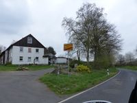
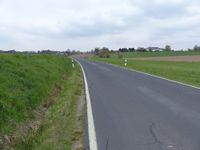
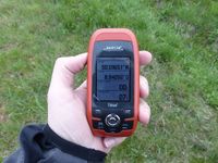
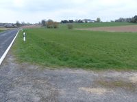
The drive from Dresden started out fine and I made good progress until I reached the Autobahn interchange at Bad Hersfeld. There the combination of the interchange between three major Autobahnen (A4, A5, A7) and road construction works with only one usable lane created a large traffic jam. In the end it took me about one hour to pass the interchange. Later I left the Autobahn at the Grünberg exit, then I drove through Grünberg until I reached the small road that led to Göbelnrod. Following that I was soon near the hashpoint. As I didn't want to stop in the middle of the road I used the next field track and parked the car on the other side of the railroad in order not to block the track. When I got out a car came down the track and the driver told me not to leave the car for too long as within 15 minutes a farmer would come along with a large machine. I answered that I would only take a few minutes. Then I walked along the road to the hashpoint. When I reached the spot it was on the meadow just on the other side of the drainage ditch and I had no problems finding the exact coordinates. All the time I was looking out towards the direction the farmer was announced to come from so that I could hurry back to my car when I saw him. For that reason I quickly took pictures and then walked back to the car. Without any farmer arriving I was able to continue my journey. I drove via Göbelnrod to Reiskirchen and went back on the Autobahn there.
|
tracklog


