Difference between revisions of "2023-08-25 48 11"
(→Participants) |
(→Tracklog) |
||
| (8 intermediate revisions by 2 users not shown) | |||
| Line 14: | Line 14: | ||
== Location == | == Location == | ||
<!-- where you've surveyed the hash to be --> | <!-- where you've surveyed the hash to be --> | ||
| + | In a forest next to Dollnstein | ||
== Participants == | == Participants == | ||
| Line 22: | Line 23: | ||
== Plans == | == Plans == | ||
<!-- what were the original plans --> | <!-- what were the original plans --> | ||
| + | [[User:Torodeas|Torodeas]] ([[User talk:Torodeas|talk]]) wants to arrive at the Dollnstein train station at 17:51, and walk to the hash from there. This gives at ETA ~18:30 at the hash | ||
== Expedition == | == Expedition == | ||
<!-- how it all turned out. your narrative goes here. --> | <!-- how it all turned out. your narrative goes here. --> | ||
| + | I'm starting to get used to these kinds of hashes by now: | ||
| + | I pick a hash in some woods I can reach from some kind of public transport, | ||
| + | I arrive at that train station or bus stop, and I have a nice hike in an unfamiliar location to the hash. | ||
| + | |||
| + | Today is one of these. Today's has is in the NW corner of the graticule, which is one of the easiest locations in [[48,11]] for me. There's even a nice train stop less than a km away from it, and that train stop has hourly service until later in the night - all good. | ||
| + | |||
| + | After arriving in Dollnstein, I notice the region is a bit hilly, and I'll have to leave the [https://de.wikipedia.org/wiki/Altm%C3%BChl Altmühl]'s valley to get to the hash. Nothing crazy, but enough elevation to make me worry a bit about the tight schedule to be back for the 19:03 train home. | ||
| + | |||
| + | On the way to the hash I notice another issue: My app-based map just becomes blank. No more helpful streets, not even general features like 'woody' or 'urban' are displayed anymore. This makes it almost close to a [[No Batteries Geohash]], and I did not prepare for that. My memory tends to be quite good, and so the general directions still available and my memory of 'there aren't that many streets in that approximate direction, just follow the street' worked out. | ||
| + | |||
| + | I even got the scheduled train 19:03 back, and didn't have to wait for another hour for the next one! | ||
== Tracklog == | == Tracklog == | ||
<!-- if your GPS device keeps a log, you may use Template:Tracklog, post a link here, or both --> | <!-- if your GPS device keeps a log, you may use Template:Tracklog, post a link here, or both --> | ||
| + | {{tracklog | Torodeas_20230825.gpx}} | ||
== Photos == | == Photos == | ||
| Line 34: | Line 48: | ||
--> | --> | ||
<gallery perrow="5"> | <gallery perrow="5"> | ||
| + | Image:20230825_4811_Proof.png | Proof | ||
| + | Image:20230835Dollnstein.png | Dollnstein train station <!-- sic! --> | ||
| + | Image:20230825 Torodeas Hashpoint.jpg | At the hash | ||
| + | Image:20230825 Torodeas View1.jpg | View from the hash | ||
| + | |||
| + | Image:20230825_Torodeas_Maps.png | Almost a technical failure | ||
</gallery> | </gallery> | ||
| Line 39: | Line 59: | ||
{{#vardefine:ribbonwidth|100%}} | {{#vardefine:ribbonwidth|100%}} | ||
<!-- Add any achievement ribbons you earned below, or remove this section --> | <!-- Add any achievement ribbons you earned below, or remove this section --> | ||
| + | {{land geohash | ||
| + | | latitude = 48 | ||
| + | | longitude = 11 | ||
| + | | date = 2023-08-25 | ||
| + | | name = Torodeas | ||
| + | }} | ||
| + | {{Public transport geohash | ||
| + | | latitude = 48 | ||
| + | | longitude = 11 | ||
| + | | date = 2023-08-25 | ||
| + | | name = Torodeas | ||
| + | | busline = 280,S1,RE16,RB16 | ||
| + | |||
| + | }} | ||
__NOTOC__ | __NOTOC__ | ||
<!-- =============== USEFUL CATEGORIES FOLLOW ================ | <!-- =============== USEFUL CATEGORIES FOLLOW ================ | ||
Delete the next line ONLY if you have chosen the appropriate categories below. If you are unsure, don't worry. People will read your report and help you with the classification. --> | Delete the next line ONLY if you have chosen the appropriate categories below. If you are unsure, don't worry. People will read your report and help you with the classification. --> | ||
| − | [[Category: | + | [[Category:Expeditions]] |
| + | [[Category:Expeditions with photos]] | ||
| + | [[Category:Coordinates reached]] | ||
<!-- ==REQUEST FOR TWITTER BOT== Please leave either the New report or the Expedition planning category in as long as you work on it. This helps the twitter bot a lot with announcing the right outcome at the right moment. --> | <!-- ==REQUEST FOR TWITTER BOT== Please leave either the New report or the Expedition planning category in as long as you work on it. This helps the twitter bot a lot with announcing the right outcome at the right moment. --> | ||
| Line 82: | Line 118: | ||
(Don't forget to delete this final close comment marker) --> | (Don't forget to delete this final close comment marker) --> | ||
| + | {{location|DE|BY|EI}} | ||
Latest revision as of 13:38, 2 September 2023
| Fri 25 Aug 2023 in 48,11: 48.8696749, 11.0565193 geohashing.info google osm bing/os kml crox |
Location
In a forest next to Dollnstein
Participants
Plans
Torodeas (talk) wants to arrive at the Dollnstein train station at 17:51, and walk to the hash from there. This gives at ETA ~18:30 at the hash
Expedition
I'm starting to get used to these kinds of hashes by now: I pick a hash in some woods I can reach from some kind of public transport, I arrive at that train station or bus stop, and I have a nice hike in an unfamiliar location to the hash.
Today is one of these. Today's has is in the NW corner of the graticule, which is one of the easiest locations in 48,11 for me. There's even a nice train stop less than a km away from it, and that train stop has hourly service until later in the night - all good.
After arriving in Dollnstein, I notice the region is a bit hilly, and I'll have to leave the Altmühl's valley to get to the hash. Nothing crazy, but enough elevation to make me worry a bit about the tight schedule to be back for the 19:03 train home.
On the way to the hash I notice another issue: My app-based map just becomes blank. No more helpful streets, not even general features like 'woody' or 'urban' are displayed anymore. This makes it almost close to a No Batteries Geohash, and I did not prepare for that. My memory tends to be quite good, and so the general directions still available and my memory of 'there aren't that many streets in that approximate direction, just follow the street' worked out.
I even got the scheduled train 19:03 back, and didn't have to wait for another hour for the next one!
Tracklog
Photos

Proof
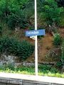
Dollnstein train station
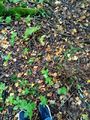
At the hash

View from the hash
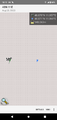
Almost a technical failure


Achievements
Torodeas earned the Land geohash achievement
|
Torodeas earned the Public transport geohash achievement
|