Difference between revisions of "2023-11-11 41 12"
(→Expedition) |
(gallery descriptions from the file pages, categories) |
||
| Line 37: | Line 37: | ||
--> | --> | ||
<gallery perrow="5"> | <gallery perrow="5"> | ||
| − | File:2023-11-11 41 12 start.jpg| | + | File:2023-11-11 41 12 start.jpg|A selfie from on high of my head and the handlebars of my old Brompton bicycle |
| − | File:2023-11-11 41 12 gianicolo.jpg| | + | File:2023-11-11 41 12 gianicolo.jpg|A view from near the lighthouse on the Janiculum hill, looking down towards the river Tiber, where the geohash is obscured by the trees in the foreground. |
| − | File:2023-11-11 41 12 map.jpg| | + | File:2023-11-11 41 12 map.jpg|Screenshot of my location relative to the geohash. I should note that I was not actually in the water, but at the edge. |
| − | File:2023-11-11 41 12 bike.jpg| | + | File:2023-11-11 41 12 bike.jpg|My Brompton half folded and on the edge of the river, roughly opposite the geohash, in the middle of the stream. |
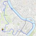
| − | File:2023-11-11 41 12 track.jpg| | + | File:2023-11-11 41 12 track.jpg|A map of the route, all 5km of it (on the bicycle). You can see where I loitered near the geohash and, perhaps, where I waited for a bus up the hill. |
</gallery> | </gallery> | ||
| − | |||
| − | |||
== Achievements == | == Achievements == | ||
| Line 51: | Line 49: | ||
__NOTOC__ | __NOTOC__ | ||
| − | + | [[Category:Expeditions]] | |
| − | + | [[Category:Expeditions with photos]] | |
| − | [[Category: | + | [[Category:Coordinates not reached]] |
| − | + | [[Category:Not reached - Mother Nature]] | |
| − | + | {{location|IT|LZ}} | |
| − | |||
| − | |||
| − | [[Category: | ||
| − | |||
| − | |||
| − | |||
| − | |||
| − | |||
| − | |||
| − | |||
| − | |||
| − | |||
| − | |||
Revision as of 22:07, 13 November 2023
| Sat 11 Nov 2023 in 41,12: 41.8965614, 12.4653802 geohashing.info google osm bing/os kml crox |
Location
In the middle of the Tiber, just upstream of the Ponte Giuseppe Mazzini
Participants
Right now only me, Jeremy Cherfas, but for the first time ever I plan to be on the bridge or on the cycle path even nearer the geohash, at 4pm.
Plans
I will take the opportunity to go for a bicycle ride along the river and will be at the geohash or on the bridge at 16:00
Expedition
I got on my bike, rode for about 5 minutes to the lighthouse on the Janiculum hill, where I took a photo. Then down the hill and along the river for a few minutes to the Ponte Mazzini. I checked my location and decided I could get even closer by going down the perilous staircase to the cycle path along the edge of the Tiber. Got as close as I could to the geohash in the middle of the river and snapped a picture of the bicycle. Then treated myself to a longer ride along the cycle path to a spot where I could fold up the bike and let a bus take me home.


