Difference between revisions of "2023-11-13 50 16"
(Created page with "{{meetup graticule|lat=50|lon=16|date=2023-11-13}} ==Location== In a field near Witoszów Dolny ==Participants== * k4be ==Plans== Planning to cycle to the pla...") |
(expedition description) |
||
| (3 intermediate revisions by one other user not shown) | |||
| Line 2: | Line 2: | ||
==Location== | ==Location== | ||
| − | + | On a field near [[wikipedia:Witoszów Dolny|Witoszów Dolny]] | |
==Participants== | ==Participants== | ||
* [[User:k4be|k4be]] | * [[User:k4be|k4be]] | ||
| + | * [[User:Piotrekoo|Piotrekoo]] | ||
==Plans== | ==Plans== | ||
| + | ===k4be=== | ||
Planning to cycle to the place, arriving at around 16:15. | Planning to cycle to the place, arriving at around 16:15. | ||
| + | |||
| + | ==Expedition== | ||
| + | ===Piotrekoo=== | ||
| + | Using a free day at work, I decided to cycle to the geohash. In the morning, I went to a store to pick up some shoe covers because the temperatures were getting lower daily. It was 12.30 pm when I was eventually ready for departure. | ||
| + | |||
| + | I could take a route similar to the one I went to two hashes: [[2023-09-08 50 16]] and [[2023-10-29 50 16]]. I went via the [[wikipedia:pl:Przełęcz Tąpadła|Tąpadła Pass]] to avoid repeating it for the third time. I hadn't been there on a bike before. The climb nearly killed me, but I started appreciating it as soon as I descended. I thought I would freeze to death. When I reached [[wikipedia:Świdnica|Świdnica]], I popped into a gas station and bought a hotdog and a coffee. This 15-minute-long stop helped me a lot. From there, it was only 8 kilometres to the geohash. | ||
| + | |||
| + | The coordinates were located on a field. I recorded proof and took some photos, and when I was ready to ride on, I saw another geohasher: [[User:k4be|k4be]]. I wanted to visit a viewpoint in [[wikipedia:Modliszów|Modliszów]], but we discussed another route for me as it was getting dark and I was running out of time. | ||
| + | |||
| + | It was supposed to be a quick 13 kilometres. But, most of the time, uphill. Well, it can be described in three words: [[wikipedia:pl:Sudecki uskok brzeżny|Sudetic Marginal Fault]]. It started raining to make it even more unpleasant, so I was twice wet. I hadn't transferred the route to my bike computer, and I took the wrong path. I arrived at [[wikipedia:pl:Wałbrzych Szczawienko|Wałbrzych Szczawienko]] a few minutes late, but my train was still waiting for a semaphore. I was at [[wikipedia:Wrocław Główny railway station|Wrocław Główny]] in about an hour and cycled further home. | ||
| + | |||
| + | |||
| + | ===k4be=== | ||
| + | It was the quickest hash for me yet, and the first time I've met another hasher too. It took a little over 6 km of cycling (through Bystrzyca Dolna) to reach the place. (My straight line distance was about 4 km but I rather wanted to follow roads.) Reached destination around 16:20. The hash was located on a cultivated field near a local road (which I happen to know well), an extremely convenient location. | ||
| + | |||
| + | After a bit of talking, I found a long stick in nearby bushes and stuck it in the field at hash location to mark it, then took a few blurry photos (it already was pretty dark after all the talking) and left. | ||
| + | |||
| + | Cycled back another route right towards Świdnica (6.5 km). | ||
| + | |||
| + | ==Photos== | ||
| + | ===Piotrekoo=== | ||
| + | <gallery> | ||
| + | 2023-11-13 50 16 Piotrekoo 01 Proof.jpg | Proof | ||
| + | 2023-11-13 50 16 Piotrekoo 02 Stupid Grin.jpg | Stupid Grin™ | ||
| + | 2023-11-13 50 16 Piotrekoo 03 Hashfield.jpg | Hashfield | ||
| + | </gallery> | ||
| + | |||
| + | |||
| + | ===k4be=== | ||
| + | <gallery> | ||
| + | 2023-11-13_50_16_001.jpeg | View east (Ślęża mountain) | ||
| + | 2023-11-13_50_16_002.jpeg | View south | ||
| + | 2023-11-13_50_16_003.jpeg | View northwest | ||
| + | 2023-11-13_50_16_004.jpeg | Geohash Droid screenshot | ||
| + | </gallery> | ||
| + | ==Tracklog== | ||
| + | ===Piotrekoo=== | ||
| + | {{tracklog | 2023-11-13 50 16 Piotrekoo 00 Tracklog.gpx}} | ||
| + | |||
| + | ==Achievements== | ||
| + | {{#vardefine:ribbonwidth|100%}} | ||
| + | {{land geohash|date=2023-11-13|latitude=50|longitude=16|name=[[User:Piotrekoo|Piotrekoo]]|image=2023-11-13 50 16 Piotrekoo 03 Hashfield.jpg}} | ||
| + | {{Drowned rat geohash|honourable=yes|date=2023-11-13|latitude=50|longitude=16|name=[[User:Piotrekoo|Piotrekoo]]|reason=rain and sweat}} | ||
| + | |||
[[Category:Expeditions]] | [[Category:Expeditions]] | ||
| − | [[Category: | + | [[Category:Coordinates reached]] |
| + | [[Category:Expeditions with photos]] | ||
{{location|PL|D|SW}} | {{location|PL|D|SW}} | ||
| + | {{user categories|user=Piotrekoo|bike=99|train=67}} | ||
Latest revision as of 09:25, 14 November 2023
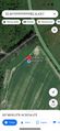
| Mon 13 Nov 2023 in 50,16: 50.8112018, 16.4317168 geohashing.info google osm bing/os kml crox |
Contents
Location
On a field near Witoszów Dolny
Participants
Plans
k4be
Planning to cycle to the place, arriving at around 16:15.
Expedition
Piotrekoo
Using a free day at work, I decided to cycle to the geohash. In the morning, I went to a store to pick up some shoe covers because the temperatures were getting lower daily. It was 12.30 pm when I was eventually ready for departure.
I could take a route similar to the one I went to two hashes: 2023-09-08 50 16 and 2023-10-29 50 16. I went via the Tąpadła Pass to avoid repeating it for the third time. I hadn't been there on a bike before. The climb nearly killed me, but I started appreciating it as soon as I descended. I thought I would freeze to death. When I reached Świdnica, I popped into a gas station and bought a hotdog and a coffee. This 15-minute-long stop helped me a lot. From there, it was only 8 kilometres to the geohash.
The coordinates were located on a field. I recorded proof and took some photos, and when I was ready to ride on, I saw another geohasher: k4be. I wanted to visit a viewpoint in Modliszów, but we discussed another route for me as it was getting dark and I was running out of time.
It was supposed to be a quick 13 kilometres. But, most of the time, uphill. Well, it can be described in three words: Sudetic Marginal Fault. It started raining to make it even more unpleasant, so I was twice wet. I hadn't transferred the route to my bike computer, and I took the wrong path. I arrived at Wałbrzych Szczawienko a few minutes late, but my train was still waiting for a semaphore. I was at Wrocław Główny in about an hour and cycled further home.
k4be
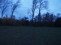
It was the quickest hash for me yet, and the first time I've met another hasher too. It took a little over 6 km of cycling (through Bystrzyca Dolna) to reach the place. (My straight line distance was about 4 km but I rather wanted to follow roads.) Reached destination around 16:20. The hash was located on a cultivated field near a local road (which I happen to know well), an extremely convenient location.
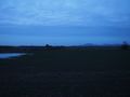
After a bit of talking, I found a long stick in nearby bushes and stuck it in the field at hash location to mark it, then took a few blurry photos (it already was pretty dark after all the talking) and left.
Cycled back another route right towards Świdnica (6.5 km).
Photos
Piotrekoo
Proof

Stupid Grin™
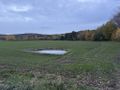
Hashfield


k4be
View east (Ślęża mountain)
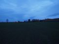
View south
View northwest

Geohash Droid screenshot


Tracklog
Piotrekoo
Achievements
Piotrekoo earned the Land geohash achievement
|
Piotrekoo earned the Drowned Rat Geohash Honourable Mention
|
- Meetup on 2023-11-13
- Meetup in 50 16
- Expeditions with tracklogs
- Land geohash achievement
- Drowned rat geohash achievement
- Expeditions
- Coordinates reached
- Expeditions with photos
- Meetup in powiat świdnicki (województwo dolnośląskie)
- Expeditions by Piotrekoo
- Piotrekoo's expeditions by bike
- Piotrekoo's expeditions by train