Difference between revisions of "2023-12-05 31 34"
Yerushalmi (talk | contribs) (Created page with "{{subst:Expedition}}") |
Yerushalmi (talk | contribs) |
||
| Line 1: | Line 1: | ||
| − | + | {{meetup graticule | |
| − | |||
| − | |||
| − | |||
| − | |||
| − | |||
| − | |||
| − | |||
| − | |||
| lat={{#explode:{{SUBPAGENAME}}| |1}} | | lat={{#explode:{{SUBPAGENAME}}| |1}} | ||
| lon={{#explode:{{SUBPAGENAME}}| |2}} | | lon={{#explode:{{SUBPAGENAME}}| |2}} | ||
| date={{#explode:{{SUBPAGENAME}}| |0}} | | date={{#explode:{{SUBPAGENAME}}| |0}} | ||
| − | }} | + | }} |
== Location == | == Location == | ||
| − | + | On agricultural land between the towns of Menuha, Segula, Nir Banim, and Zavdiel. It looks very close to the path between two fields. | |
== Participants == | == Participants == | ||
| − | + | [[User:Yerushalmi|Yerushalmi]] ([[User talk:Yerushalmi|talk]]) | |
| − | |||
== Plans == | == Plans == | ||
| − | + | Take the Jerusalem-Tel Aviv train, transfer to a train to Kiryat Gat, take a bus to the nearest intersection to the point, walk to the point, and do the reverse to get home. | |
== Expedition == | == Expedition == | ||
| − | + | Mostly as expected. My wife needed me to drop something off for her in Tel Aviv, so I left a bit later than intended - took the 09:09 train instead of 08:39. Luckily there were enough people on the train for a minyan. | |
| − | + | I got out in Tel Aviv, delivered the package, and went back to the train station. Moovit said I would have to wait over an hour for the next train to Kiryat Gat, but this turned out to not be true: there was a train only half an hour later, which I took. Never outsource your brain to technology! | |
| − | + | ||
| + | When I got to Kiryat Gat, I had the option of taking a bus to the bus that would take me to the point, or walking. Since there was plenty of time and I need to lose weight, I walked. | ||
| + | |||
| + | Bus to Segula Junction. Easy enough. Five-minute walk to the point, which turned out to be in the center of a field rather than near a path as the satellite images implied. There was nobody around to ask permission, but also no No Trespassing signs. There were no crops growing because it's the beginning of winter; clearly the field had been recently planted. So it wouldn't bother anyone - I walked to the point and back. | ||
| + | |||
| + | Because of the delay, I took a direct bus to the Jerusalem from the bus station nearest the point. It's much faster than the train via Tel Aviv; the only reason I prefer the train is because I can get stuff done on it, whereas on buses I get very sick. | ||
== Photos == | == Photos == | ||
| Line 33: | Line 29: | ||
--> | --> | ||
<gallery perrow="5"> | <gallery perrow="5"> | ||
| + | Screenshot_20231205_122551_Geohash Droid.jpg | Proof | ||
| + | 20231205_122014.jpg | Everything was overcast and ugly | ||
| + | 20231205_122421.jpg | Still overcast and ugly | ||
| + | 20231205_122600.jpg | But the panorama at the point turned out unexpectedly beautiful | ||
</gallery> | </gallery> | ||
| − | |||
| − | |||
| − | |||
| − | |||
| − | |||
| − | |||
| − | |||
| − | |||
| − | |||
| − | |||
| − | |||
| − | |||
| − | |||
| − | |||
| − | |||
| − | |||
| − | |||
| − | |||
| − | |||
[[Category:Expeditions]] | [[Category:Expeditions]] | ||
| − | |||
[[Category:Expeditions with photos]] | [[Category:Expeditions with photos]] | ||
| − | |||
| − | |||
| − | |||
| − | |||
| − | |||
[[Category:Coordinates reached]] | [[Category:Coordinates reached]] | ||
| − | |||
| − | |||
| − | |||
| − | |||
| − | |||
| − | |||
| − | |||
| − | |||
| − | |||
| − | |||
| − | |||
| − | |||
| − | |||
| − | |||
| − | |||
| − | |||
| − | |||
| − | |||
Revision as of 16:14, 5 December 2023
| Tue 5 Dec 2023 in 31,34: 31.6632159, 34.7715721 geohashing.info google osm bing/os kml crox |
Contents
Location
On agricultural land between the towns of Menuha, Segula, Nir Banim, and Zavdiel. It looks very close to the path between two fields.
Participants
Plans
Take the Jerusalem-Tel Aviv train, transfer to a train to Kiryat Gat, take a bus to the nearest intersection to the point, walk to the point, and do the reverse to get home.
Expedition
Mostly as expected. My wife needed me to drop something off for her in Tel Aviv, so I left a bit later than intended - took the 09:09 train instead of 08:39. Luckily there were enough people on the train for a minyan.
I got out in Tel Aviv, delivered the package, and went back to the train station. Moovit said I would have to wait over an hour for the next train to Kiryat Gat, but this turned out to not be true: there was a train only half an hour later, which I took. Never outsource your brain to technology!
When I got to Kiryat Gat, I had the option of taking a bus to the bus that would take me to the point, or walking. Since there was plenty of time and I need to lose weight, I walked.
Bus to Segula Junction. Easy enough. Five-minute walk to the point, which turned out to be in the center of a field rather than near a path as the satellite images implied. There was nobody around to ask permission, but also no No Trespassing signs. There were no crops growing because it's the beginning of winter; clearly the field had been recently planted. So it wouldn't bother anyone - I walked to the point and back.
Because of the delay, I took a direct bus to the Jerusalem from the bus station nearest the point. It's much faster than the train via Tel Aviv; the only reason I prefer the train is because I can get stuff done on it, whereas on buses I get very sick.
Photos

Proof
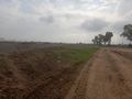
Everything was overcast and ugly
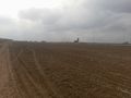
Still overcast and ugly
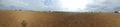
But the panorama at the point turned out unexpectedly beautiful


