Difference between revisions of "2023-12-17 31 34"
Yerushalmi (talk | contribs) (Created page with "{{subst:Expedition}}") |
Yerushalmi (talk | contribs) |
||
| Line 13: | Line 13: | ||
}}<!-- edit as necessary --> | }}<!-- edit as necessary --> | ||
== Location == | == Location == | ||
| − | + | In a field outside Beit Guvrin. In the satellite photo it looks agricultural, but Amud Anan says it's a poppy field (https://en.wikipedia.org/wiki/Anemone_coronaria), which is the national flower of Israel, a protected species, and not grown commercially. | |
== Participants == | == Participants == | ||
| − | + | [[User:Yerushalmi|Yerushalmi]] ([[User talk:Yerushalmi|talk]]) | |
| − | |||
== Plans == | == Plans == | ||
| − | + | Train to Kiryat Gat, then bus to Beit Guvrin, then the reverse to return home. | |
== Expedition == | == Expedition == | ||
| − | + | I left Jerusalem on the 8:39 train and davened on the train minyan. At Tel Aviv Hahagana station I switched to the train to Kiryat Gat - but it was delayed by ten minutes. This was a problem, as ten minutes was almost exactly the buffer time I had between arriving in Kiryat Gat and catching the bus to Beit Guvrin. | |
| − | + | Both trains were packed. Filled to the brim with soldiers heading south to the front. It was depressing, looking around me and knowing some of them wouldn't be coming back. | |
| − | + | ||
| + | The train to Kiryat Gat made up a little bit of time, but not enough. Even though I ran, I didn't make it to the bus stop in time to even see the 66 bus I was supposed to transfer to. Oddly, however, I asked the people at the bus stop and they hadn't seen it go by. | ||
| + | |||
| + | Aha! But looking at the map, the 66 does this very roundabout route through Kiryat Gat before heading east on the highway. If I walk, I might be able to catch it at one of the highway stops! | ||
| + | |||
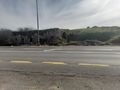
| + | This is where my lack of sense of scale failed me. The walk was far longer than I expected and by the time I got halfway to the highway stop I knew the bus was long gone. So, reopening Moovit, I checked my options; I'd need to continue to the highway stop anyway and take a different bus from there. Fine. On the way I saw a curious building, so it's not a complete waste of time. | ||
| + | |||
| + | [[File:20231217_104015.jpg|400px]] | ||
| + | |||
| + | When I reached the highway stop I saw the 66 bus was not listed. Considering the people at the bus stop hadn't seen it go by, I suspect the line no longer exists and Moovit isn't updated. | ||
| + | |||
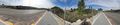
| + | Anyway, I ate lunch at the bus stop while waiting, and took the bus an hour later to Beit Guvrin. A short walk along the highway to the field, and then a choice. | ||
| + | |||
| + | [[File:20231217_115611.jpg|400px]] | ||
| + | |||
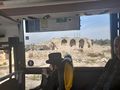
| + | The field *does* look cultivated, with tiny stalks growing in neat little rows. But at the same time, there are plenty of tire tracks going through the field, which implies that nobody really cares about it from a commercial standpoint - which tracks with Amud Anan's claim that it's a poppy field (obviously way too early in winter for there to be flowers). Do I go in or not? | ||
| + | |||
| + | I decided that based on the evidence before me it's likely a town-owned field that's planted for beautification purposes, and therefore I could go in. But I stuck to the tire tracks as much as I could so that I wouldn't trample anything that wasn't already trampled. It was an easy walk to the point and back. | ||
| + | |||
| + | To go home I walked back to the bus stop, then took the train. Simple enough. And I got to see a Crusader-era castle! | ||
== Photos == | == Photos == | ||
| − | |||
| − | |||
| − | |||
<gallery perrow="5"> | <gallery perrow="5"> | ||
| + | File:20231217_114746.jpg | Cacti! | ||
| + | File:Screenshot_20231217_120102_Geohash Droid.jpg | Proof | ||
| + | File:20231217_120113.jpg | Panorama at the point | ||
| + | File:20231217_121512.jpg | Why is there a rock with a pink ribbon tied around it? | ||
| + | File:20231217_121821.jpg | Remnants of a crusader castle | ||
| + | File:20231217_122111.jpg | More ancient ruins on the other side of the street | ||
| + | File:20231217_122135.jpg | Panorama of crusader castle, ruins on the other side of the street, and two bus stops in between | ||
| + | File:20231217_122323.jpg | From the bus I had a better view of the castle (it's now a tourist attraction) | ||
| + | File:20231217_123612.jpg | Cool fountain archway at the entrance to Kiryat Gat | ||
</gallery> | </gallery> | ||
| − | + | ||
| − | |||
| − | |||
__NOTOC__ | __NOTOC__ | ||
| − | |||
| − | |||
| − | |||
| − | |||
| − | |||
| − | |||
| − | |||
| − | |||
| − | |||
| − | |||
| − | |||
| − | |||
| − | |||
[[Category:Expeditions]] | [[Category:Expeditions]] | ||
| − | |||
[[Category:Expeditions with photos]] | [[Category:Expeditions with photos]] | ||
| − | |||
| − | |||
| − | |||
| − | |||
| − | |||
[[Category:Coordinates reached]] | [[Category:Coordinates reached]] | ||
| − | |||
| − | |||
| − | |||
| − | |||
| − | |||
| − | |||
| − | |||
| − | |||
| − | |||
| − | |||
| − | |||
| − | |||
| − | |||
| − | |||
| − | |||
| − | |||
| − | |||
| − | |||
Revision as of 10:15, 18 December 2023
| Sun 17 Dec 2023 in 31,34: 31.6131547, 34.9032940 geohashing.info google osm bing/os kml crox |
Location
In a field outside Beit Guvrin. In the satellite photo it looks agricultural, but Amud Anan says it's a poppy field (https://en.wikipedia.org/wiki/Anemone_coronaria), which is the national flower of Israel, a protected species, and not grown commercially.
Participants
Plans
Train to Kiryat Gat, then bus to Beit Guvrin, then the reverse to return home.
Expedition
I left Jerusalem on the 8:39 train and davened on the train minyan. At Tel Aviv Hahagana station I switched to the train to Kiryat Gat - but it was delayed by ten minutes. This was a problem, as ten minutes was almost exactly the buffer time I had between arriving in Kiryat Gat and catching the bus to Beit Guvrin.
Both trains were packed. Filled to the brim with soldiers heading south to the front. It was depressing, looking around me and knowing some of them wouldn't be coming back.
The train to Kiryat Gat made up a little bit of time, but not enough. Even though I ran, I didn't make it to the bus stop in time to even see the 66 bus I was supposed to transfer to. Oddly, however, I asked the people at the bus stop and they hadn't seen it go by.
Aha! But looking at the map, the 66 does this very roundabout route through Kiryat Gat before heading east on the highway. If I walk, I might be able to catch it at one of the highway stops!
This is where my lack of sense of scale failed me. The walk was far longer than I expected and by the time I got halfway to the highway stop I knew the bus was long gone. So, reopening Moovit, I checked my options; I'd need to continue to the highway stop anyway and take a different bus from there. Fine. On the way I saw a curious building, so it's not a complete waste of time.

When I reached the highway stop I saw the 66 bus was not listed. Considering the people at the bus stop hadn't seen it go by, I suspect the line no longer exists and Moovit isn't updated.
Anyway, I ate lunch at the bus stop while waiting, and took the bus an hour later to Beit Guvrin. A short walk along the highway to the field, and then a choice.

The field *does* look cultivated, with tiny stalks growing in neat little rows. But at the same time, there are plenty of tire tracks going through the field, which implies that nobody really cares about it from a commercial standpoint - which tracks with Amud Anan's claim that it's a poppy field (obviously way too early in winter for there to be flowers). Do I go in or not?
I decided that based on the evidence before me it's likely a town-owned field that's planted for beautification purposes, and therefore I could go in. But I stuck to the tire tracks as much as I could so that I wouldn't trample anything that wasn't already trampled. It was an easy walk to the point and back.
To go home I walked back to the bus stop, then took the train. Simple enough. And I got to see a Crusader-era castle!
Photos
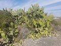
Cacti!
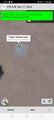
Proof
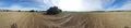
Panorama at the point
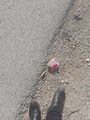
Why is there a rock with a pink ribbon tied around it?
Remnants of a crusader castle
More ancient ruins on the other side of the street
Panorama of crusader castle, ruins on the other side of the street, and two bus stops in between
From the bus I had a better view of the castle (it's now a tourist attraction)
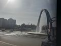
Cool fountain archway at the entrance to Kiryat Gat


