Difference between revisions of "2023-12-17 63 26"
(Created page with "{{subst:expedition}}") |
|||
| (4 intermediate revisions by 2 users not shown) | |||
| Line 1: | Line 1: | ||
| − | + | {{meetup graticule | |
| − | |||
| − | |||
| − | |||
| − | |||
| − | |||
| − | |||
| − | |||
| − | |||
| lat={{#explode:{{SUBPAGENAME}}| |1}} | | lat={{#explode:{{SUBPAGENAME}}| |1}} | ||
| lon={{#explode:{{SUBPAGENAME}}| |2}} | | lon={{#explode:{{SUBPAGENAME}}| |2}} | ||
| date={{#explode:{{SUBPAGENAME}}| |0}} | | date={{#explode:{{SUBPAGENAME}}| |0}} | ||
| − | }} | + | }} |
== Location == | == Location == | ||
| − | + | In a forest next to a small road near Kultavuori, Iisalmi. | |
| + | |||
| + | The point on a topographic map: {{MapSiteLink | lat = 63.6131547 | lon = 26.9032940 | title = Geohash+{{#explode:{{SUBPAGENAME}}| |0}}+{{#explode:{{SUBPAGENAME}}| |1}}+{{#explode:{{SUBPAGENAME}}| |2}} }} | ||
== Participants == | == Participants == | ||
| − | + | * [[User:Kripakko|Kripakko]] | |
| − | |||
| − | == | + | == Expedition == |
| − | + | I was driving alone from Kuopio to Oulu, and this point looked like an easy grab if I would make a small detour. | |
| + | It was located nearly next to the road, so I would just park as near as possible and take a very quick walk to the woods. | ||
| + | Well, in the summer it would have worked that way, but winter makes things difficult as I should have expected. | ||
| − | + | I went and drove past the point, observing that there was a wider part in the road in the slope near the hashpoint. | |
| − | + | All right, I will turn the car around and park there, I thought. | |
| + | On the way back, I was not paying attention and drove past it, but no trouble, I will just reverse down the hill and steer to the wide part which was to the left of me, I thought. | ||
| + | That was the big mistake – I was overconfident and took a too big risk. | ||
| + | The rear corner of the car clipped the wall of snow next to the road and got stuck. | ||
| + | The car would not move backwards, and there was not enough grip under the tyres to able to move forward. | ||
| + | Of course, I did not have a shovel with me, so I started digging the snow away with my hands. | ||
| + | I was confident that I would eventually get the car free as it was not badly stuck, but thankfully I did not need to dig very long until a local man appeared, driving a car. | ||
| + | He was extremely helpful: he went and turned his car around, gave me a little pull and got me out. | ||
| + | I was going to leave the car there for a short while do the geohash visit, but he insisted I move out of the way, | ||
| + | so I drove back to the highway and parked the car to a parking area about half a kilometre away. | ||
| + | |||
| + | In hindsight, I could have gone to the geohash quickly while the car was stuck and then continue getting it unstuck. | ||
| + | Actually, as I immediately realised, I should have just turned around again and parked facing down the hill instead of trying to reverse in such a snowy slope. | ||
| + | But you live and learn. | ||
| + | Local man, you will probably never read this, but if you do, I am very grateful for the generous help and sorry for the inconvenience I caused. | ||
| + | I did not explain why I was there because you did not ask and I did not want to keep you any longer. | ||
| − | + | Then, my plan changed to walking along the road to the geohash, which I did with no difficulty. | |
| − | + | I could tell from the consistency of the snow that it was slightly freezing, but I did not record the temperature. | |
| + | The meteorological institute reports a temperature of −1.8 °C 28 km away in Kaarakkala, Vieremä around that time, so close enough. | ||
| + | I do not even know how much time I wasted during this little adventure, but then I was in no hurry, so it does not matter in the end. | ||
| + | I continued my way towards [[2023-12-17 63 25]] next. | ||
== Photos == | == Photos == | ||
| − | |||
| − | |||
| − | |||
<gallery perrow="5"> | <gallery perrow="5"> | ||
| + | Image:2023-12-17_63_26_01-car.jpg | The car parked to the parking area next to the highway. | ||
| + | Image:2023-12-17_63_26_02-road.jpg | The snowy road in which I got stuck and which I eventually walked. | ||
| + | Image:2023-12-17_63_26_03-gpsr1.jpg | Proof of location. | ||
| + | Image:2023-12-17_63_26_04-gpsr2.jpg | Proof of date and time. | ||
| + | Image:2023-12-17_63_26_05-selfie.jpg | Stupid Grin™ | ||
</gallery> | </gallery> | ||
== Achievements == | == Achievements == | ||
| − | {{# | + | {{land geohash |
| − | + | | name = [[User:Kripakko|Kripakko]] | |
| + | | latitude = {{#explode:{{SUBPAGENAME}}| |1}} | longitude = {{#explode:{{SUBPAGENAME}}| |2}} | date = {{#explode:{{SUBPAGENAME}}| |0}} | ||
| + | }} | ||
| + | {{frozen geohash | ||
| + | | name = [[User:Kripakko|Kripakko]] | ||
| + | | latitude = {{#explode:{{SUBPAGENAME}}| |1}} | longitude = {{#explode:{{SUBPAGENAME}}| |2}} | date = {{#explode:{{SUBPAGENAME}}| |0}} | ||
| + | }} | ||
__NOTOC__ | __NOTOC__ | ||
| − | |||
| − | |||
| − | |||
| − | |||
| − | |||
| − | |||
| − | |||
| − | |||
| − | |||
| − | |||
| − | |||
| − | |||
| − | |||
[[Category:Expeditions]] | [[Category:Expeditions]] | ||
| − | |||
[[Category:Expeditions with photos]] | [[Category:Expeditions with photos]] | ||
| − | |||
| − | |||
| − | |||
| − | |||
| − | |||
[[Category:Coordinates reached]] | [[Category:Coordinates reached]] | ||
| − | + | {{location|FI|15}} | |
| − | |||
| − | |||
| − | |||
| − | |||
| − | |||
| − | |||
| − | |||
| − | |||
| − | |||
| − | |||
| − | |||
| − | |||
| − | |||
| − | |||
| − | |||
| − | |||
| − | |||
Revision as of 23:25, 19 December 2023
| Sun 17 Dec 2023 in 63,26: 63.6131547, 26.9032940 geohashing.info google osm bing/os kml crox |
Location
In a forest next to a small road near Kultavuori, Iisalmi.
The point on a topographic map: [1]
Participants
Expedition
I was driving alone from Kuopio to Oulu, and this point looked like an easy grab if I would make a small detour. It was located nearly next to the road, so I would just park as near as possible and take a very quick walk to the woods. Well, in the summer it would have worked that way, but winter makes things difficult as I should have expected.
I went and drove past the point, observing that there was a wider part in the road in the slope near the hashpoint. All right, I will turn the car around and park there, I thought. On the way back, I was not paying attention and drove past it, but no trouble, I will just reverse down the hill and steer to the wide part which was to the left of me, I thought. That was the big mistake – I was overconfident and took a too big risk. The rear corner of the car clipped the wall of snow next to the road and got stuck. The car would not move backwards, and there was not enough grip under the tyres to able to move forward. Of course, I did not have a shovel with me, so I started digging the snow away with my hands. I was confident that I would eventually get the car free as it was not badly stuck, but thankfully I did not need to dig very long until a local man appeared, driving a car. He was extremely helpful: he went and turned his car around, gave me a little pull and got me out. I was going to leave the car there for a short while do the geohash visit, but he insisted I move out of the way, so I drove back to the highway and parked the car to a parking area about half a kilometre away.
In hindsight, I could have gone to the geohash quickly while the car was stuck and then continue getting it unstuck. Actually, as I immediately realised, I should have just turned around again and parked facing down the hill instead of trying to reverse in such a snowy slope. But you live and learn. Local man, you will probably never read this, but if you do, I am very grateful for the generous help and sorry for the inconvenience I caused. I did not explain why I was there because you did not ask and I did not want to keep you any longer.
Then, my plan changed to walking along the road to the geohash, which I did with no difficulty. I could tell from the consistency of the snow that it was slightly freezing, but I did not record the temperature. The meteorological institute reports a temperature of −1.8 °C 28 km away in Kaarakkala, Vieremä around that time, so close enough. I do not even know how much time I wasted during this little adventure, but then I was in no hurry, so it does not matter in the end. I continued my way towards 2023-12-17 63 25 next.
Photos
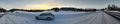
The car parked to the parking area next to the highway.
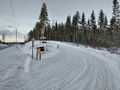
The snowy road in which I got stuck and which I eventually walked.
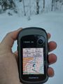
Proof of location.
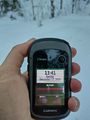
Proof of date and time.
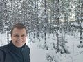
Stupid Grin™


Achievements
Kripakko earned the Land geohash achievement
|
