Difference between revisions of "2024-01-01 32 34"
Yerushalmi (talk | contribs) (Created page with "{{subst:Expedition}}") |
Yerushalmi (talk | contribs) |
||
| Line 13: | Line 13: | ||
}}<!-- edit as necessary --> | }}<!-- edit as necessary --> | ||
== Location == | == Location == | ||
| − | + | In a field just off the intersection between Route 44 and Route 412. According to the satellite photo, some of it is agricultural, but the part with the point in it looks untended. | |
== Participants == | == Participants == | ||
| − | + | [[User:Yerushalmi|Yerushalmi]] ([[User talk:Yerushalmi|talk]]) | |
| − | |||
== Plans == | == Plans == | ||
| − | + | My son has strep, and my daughter had an appointment to look at a high school, so I didn't know if I'd be able to go for the point or not. I decided early morning to keep the plans in my back pocket and pull them out if I had the time. | |
| + | |||
| + | And what are those plans? Train to Tel Aviv, bus to the intersection between 44 and 412, walk to the point (street view shows the field is accessible behind the bus stop), walk back, take the bus from the other side of the intersection, train back to Jerusalem. | ||
== Expedition == | == Expedition == | ||
| − | + | In the end I was able to go around midday. Train to Tel Aviv, easy. I couldn't take the bus directly, though; I had to drop off one of my wife's paintings at an art gallery, so I walked there first. Then I looked up buses to the intersection from that part of Tel Aviv - there were several to choose from, easy enough. | |
| − | + | When I arrived at the intersection, I discovered that the bus stop in Street View was no longer in use; enough buses stop there that they now had a separate lane so as not to block up traffic. Which meant I technically had to illegally cross the offramp (gasp!) to get to the long-abandoned bus stop. | |
| − | |||
| − | + | Behind the bus stop was massive overgrowth, and I mean massive. Each step, my foot sank half a meter into the foliage before not even reaching the ground; I was supported entirely by density of foliage. Only a few steps later, however, was a muddy creek. I didn't want to sink into *that*, but it was either that or jump across... | |
| − | |||
| − | |||
| − | |||
| − | |||
| − | |||
| − | + | [[File:20240101_133517.jpg|400px]] | |
| − | |||
| − | |||
| − | + | Ah. Never mind. That's convenient. | |
| − | |||
| − | |||
| − | |||
| − | + | The ladder was fairly stable, but I did have to keep careful balance while crossing it. From there it was a slow but steady slog through the dense foliage to the point, a slow but steady slog back to the ladder, carefully cross the creek on the ladder, illegally cross the offramp, and then head back to the bus station. | |
| − | < | + | == Photos == |
| − | + | <gallery perrow="5"> | |
| − | + | File:20240101_133352.jpg | A long-abandoned bus stop | |
| − | + | File:20240101_133517.jpg | A very convenient ladder laid across the creek. I have no idea who put it here or why. Barring geohashing, who needs to be here? | |
| + | File:20240101_133356.jpg | Overgrowth, with a Mekorot water installation in the background. That's my best guess at the purpose for the ladder. | ||
| + | File:Screenshot_20240101_134046_Geohash Droid.jpg | Proof | ||
| + | File:20240101_134057.jpg | Panorama at the point | ||
| + | </gallery> | ||
| − | |||
| − | |||
| − | |||
[[Category:Expeditions]] | [[Category:Expeditions]] | ||
| − | |||
[[Category:Expeditions with photos]] | [[Category:Expeditions with photos]] | ||
| − | |||
| − | |||
| − | |||
| − | |||
| − | |||
[[Category:Coordinates reached]] | [[Category:Coordinates reached]] | ||
| − | |||
| − | |||
| − | |||
| − | |||
| − | |||
| − | |||
| − | |||
| − | |||
| − | |||
| − | |||
| − | |||
| − | |||
| − | |||
| − | |||
| − | |||
| − | |||
| − | |||
| − | |||
Revision as of 20:46, 1 January 2024
| Mon 1 Jan 2024 in 32,34: 32.0001178, 34.8192533 geohashing.info google osm bing/os kml crox |
Contents
Location
In a field just off the intersection between Route 44 and Route 412. According to the satellite photo, some of it is agricultural, but the part with the point in it looks untended.
Participants
Plans
My son has strep, and my daughter had an appointment to look at a high school, so I didn't know if I'd be able to go for the point or not. I decided early morning to keep the plans in my back pocket and pull them out if I had the time.
And what are those plans? Train to Tel Aviv, bus to the intersection between 44 and 412, walk to the point (street view shows the field is accessible behind the bus stop), walk back, take the bus from the other side of the intersection, train back to Jerusalem.
Expedition
In the end I was able to go around midday. Train to Tel Aviv, easy. I couldn't take the bus directly, though; I had to drop off one of my wife's paintings at an art gallery, so I walked there first. Then I looked up buses to the intersection from that part of Tel Aviv - there were several to choose from, easy enough.
When I arrived at the intersection, I discovered that the bus stop in Street View was no longer in use; enough buses stop there that they now had a separate lane so as not to block up traffic. Which meant I technically had to illegally cross the offramp (gasp!) to get to the long-abandoned bus stop.
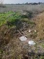
Behind the bus stop was massive overgrowth, and I mean massive. Each step, my foot sank half a meter into the foliage before not even reaching the ground; I was supported entirely by density of foliage. Only a few steps later, however, was a muddy creek. I didn't want to sink into *that*, but it was either that or jump across...

Ah. Never mind. That's convenient.
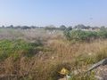
The ladder was fairly stable, but I did have to keep careful balance while crossing it. From there it was a slow but steady slog through the dense foliage to the point, a slow but steady slog back to the ladder, carefully cross the creek on the ladder, illegally cross the offramp, and then head back to the bus station.
Photos
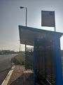
A long-abandoned bus stop
A very convenient ladder laid across the creek. I have no idea who put it here or why. Barring geohashing, who needs to be here?
Overgrowth, with a Mekorot water installation in the background. That's my best guess at the purpose for the ladder.
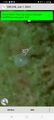
Proof
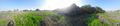
Panorama at the point


