Difference between revisions of "2024-01-04 58 5"
From Geohashing
(→Photos) |
(→Photos) |
||
| Line 41: | Line 41: | ||
Image:2024-01-04_58_5_Pica42_1704360705461.jpg|Årsland [https://openstreetmap.org/?mlat=58.59229140&mlon=5.67092400&zoom=16 @58.5923,5.6709] | Image:2024-01-04_58_5_Pica42_1704360705461.jpg|Årsland [https://openstreetmap.org/?mlat=58.59229140&mlon=5.67092400&zoom=16 @58.5923,5.6709] | ||
Image:20240104 58 5 W-2.jpg|thumb|View to the west | Image:20240104 58 5 W-2.jpg|thumb|View to the west | ||
| − | + | Image:20240104 58 5 S-2.jpg|thumb|View to the south | |
Revision as of 12:26, 4 January 2024
| Thu 4 Jan 2024 in 58,5: 58.5922998, 5.6709262 geohashing.info google osm bing/os kml crox |

Location
On a farm between Varhaug and Vigrestad in Hå, Norway
Participants
Plans
Expedition
Tracklog
Photos
Årsland @58.5923,5.6709
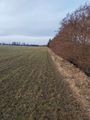
View to the west
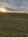
View to the south


Achievements