Difference between revisions of "2024-01-12 64 24"
| Line 14: | Line 14: | ||
== Expedition == | == Expedition == | ||
| − | + | We recently purchased a car, and so we can now go adventuring with it as long as we feel like paying for and burning fuel. | |
| + | Actually, the first time I went geohashing with it was on [[2023-12-17 63 26|2023-12-17]], | ||
| + | but this was the first trip with it that was done just for geohashing. | ||
| + | Still, I will continue to prefer cycling whenever possible and feasible. | ||
| + | |||
| + | This hashpoint was so conveniently located that we could not resist going for a drive in the evening. | ||
| + | It would be a 130-kilometre trip in the dark, in the coldest winter, on mostly small roads unknown to us – sounds like a perfect adventure! | ||
| + | So we went. | ||
| + | I drove from Oulu to Liminka and then followed regional road 813 via Lumijoki to Siikajoenkylä. | ||
| + | It is probably a very scenic road in daylight, but this time we could not see much beyond what the main beam could illuminate. | ||
| + | We started getting closer eventually, and I ended up missing the junction because we both misread the map. Whoops! | ||
| + | After a quick turnaround and a short stretch of road, we were at the hashpoint. | ||
| + | |||
| + | The point was not in a particularly special place: it was just on a road that leads to a foster care house. | ||
| + | There was a road loop in front of the house, so I drove through the point, turned the car around in the loop and stopped at the point on the way back. | ||
| + | I recorded proof of GPS location and the ambient temperature, which according to the car's thermometer was −23 °C. | ||
| + | I then stepped out of the car to take a quick selfie and to experience the temperature briefly. | ||
| + | There was absolutely no traffic (except a car idling on the nearby parking area), so I did not inconvenience anyone. | ||
| + | In fact, unless there was a parking prohibition sign that I missed, it was not even illegal to park there for a while. | ||
| + | |||
| + | After getting back to the car, I drove to the nearby parking area, and we planned where to go next. | ||
| + | We decided to take an alternative route back to Oulu via Revonlahti and to get food on the way from Ramin grilli in Kempele. | ||
| + | We were not sure which of the two roads that follow the Siikajoki river would better to take, | ||
| + | so we chose the one with the shorter road number (807 vs. 8110 – three-number regional roads are usually well maintained). | ||
| + | That was the wrong choice: we did not know that this particular road had been declared Finland's <q>worst village road</q> in 2022 | ||
| + | by a Finnish tabloid | ||
| + | (In Finnish: [https://www.iltalehti.fi/kotimaa/a/fc1bde9f-616e-4b0c-8ae6-42b9c5b27225]) and for a reason. | ||
| + | It was narrow, very winding and dark. | ||
| + | On the other hand, it was fun to drive with no hurry and no traffic. | ||
| + | Thankfully, the road surface was mostly acceptable in the winter, | ||
| + | but apparently it is extremely bad during and after rasputitsa. | ||
| + | |||
| + | Before the trip, I had thought about attaching my action camera to work as a dashcam, | ||
| + | but I had discarded the idea because it would not be very interesting to watch due to the darkness. | ||
| + | However, this terrible road might have been interesting enough regardless. Oh well. | ||
| + | Maybe I will try it sometime when I drive during daylight. | ||
| + | |||
| + | We got to a bigger highway, stopped in Kempele to get food and eventually got home about two and a half hours after leaving. | ||
| + | The length of the trip was about 135 kilometres according to the car's odometer. | ||
== Tracklog == | == Tracklog == | ||
| Line 36: | Line 74: | ||
__NOTOC__ | __NOTOC__ | ||
| − | |||
| − | |||
| − | |||
| − | |||
| − | |||
| − | |||
| − | |||
| − | |||
| − | |||
| − | |||
| − | |||
| − | |||
| − | |||
[[Category:Expeditions]] | [[Category:Expeditions]] | ||
| − | |||
[[Category:Expeditions with photos]] | [[Category:Expeditions with photos]] | ||
| − | |||
| − | |||
| − | |||
| − | |||
| − | |||
[[Category:Coordinates reached]] | [[Category:Coordinates reached]] | ||
| − | |||
| − | |||
| − | |||
| − | |||
| − | |||
| − | |||
| − | |||
| − | |||
| − | |||
| − | |||
| − | |||
| − | |||
| − | |||
| − | |||
| − | |||
| − | |||
| − | |||
| − | |||
Revision as of 00:48, 13 January 2024
| Fri 12 Jan 2024 in 64,24: 64.8131277, 24.7481457 geohashing.info google osm bing/os kml crox |
Location
On a public road in Siikajoenkylä village, Siikajoki.
The point on a topographic map: [1]
Participants
- Kripakko
- Kripakko's fiancée
Expedition
We recently purchased a car, and so we can now go adventuring with it as long as we feel like paying for and burning fuel. Actually, the first time I went geohashing with it was on 2023-12-17, but this was the first trip with it that was done just for geohashing. Still, I will continue to prefer cycling whenever possible and feasible.
This hashpoint was so conveniently located that we could not resist going for a drive in the evening. It would be a 130-kilometre trip in the dark, in the coldest winter, on mostly small roads unknown to us – sounds like a perfect adventure! So we went. I drove from Oulu to Liminka and then followed regional road 813 via Lumijoki to Siikajoenkylä. It is probably a very scenic road in daylight, but this time we could not see much beyond what the main beam could illuminate. We started getting closer eventually, and I ended up missing the junction because we both misread the map. Whoops! After a quick turnaround and a short stretch of road, we were at the hashpoint.
The point was not in a particularly special place: it was just on a road that leads to a foster care house. There was a road loop in front of the house, so I drove through the point, turned the car around in the loop and stopped at the point on the way back. I recorded proof of GPS location and the ambient temperature, which according to the car's thermometer was −23 °C. I then stepped out of the car to take a quick selfie and to experience the temperature briefly. There was absolutely no traffic (except a car idling on the nearby parking area), so I did not inconvenience anyone. In fact, unless there was a parking prohibition sign that I missed, it was not even illegal to park there for a while.
After getting back to the car, I drove to the nearby parking area, and we planned where to go next.
We decided to take an alternative route back to Oulu via Revonlahti and to get food on the way from Ramin grilli in Kempele.
We were not sure which of the two roads that follow the Siikajoki river would better to take,
so we chose the one with the shorter road number (807 vs. 8110 – three-number regional roads are usually well maintained).
That was the wrong choice: we did not know that this particular road had been declared Finland's worst village road
in 2022
by a Finnish tabloid
(In Finnish: [2]) and for a reason.
It was narrow, very winding and dark.
On the other hand, it was fun to drive with no hurry and no traffic.
Thankfully, the road surface was mostly acceptable in the winter,
but apparently it is extremely bad during and after rasputitsa.
Before the trip, I had thought about attaching my action camera to work as a dashcam, but I had discarded the idea because it would not be very interesting to watch due to the darkness. However, this terrible road might have been interesting enough regardless. Oh well. Maybe I will try it sometime when I drive during daylight.
We got to a bigger highway, stopped in Kempele to get food and eventually got home about two and a half hours after leaving. The length of the trip was about 135 kilometres according to the car's odometer.
Tracklog
Photos
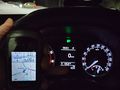
Proof of location and temperature.
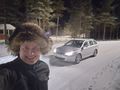
Selfie outside the car and the surroundings.


Achievements
Kripakko earned the Land geohash achievement
|
