Difference between revisions of "2024-02-11 47 -122"
From Geohashing
Coyotebush (talk | contribs) ([live picture]Geohasher [https://openstreetmap.org/?mlat=47.51476944&mlon=-122.34573056&zoom=16 @47.5148,-122.3457]) |
Coyotebush (talk | contribs) ([live picture]Plaza panorama [https://openstreetmap.org/?mlat=47.51449167&mlon=-122.34496389&zoom=16 @47.5145,-122.3450]) |
||
| Line 50: | Line 50: | ||
Image:2024-02-11_47_-122_coyotebush_1707701295383.jpg|Geohasher [https://openstreetmap.org/?mlat=47.51476944&mlon=-122.34573056&zoom=16 @47.5148,-122.3457] | Image:2024-02-11_47_-122_coyotebush_1707701295383.jpg|Geohasher [https://openstreetmap.org/?mlat=47.51476944&mlon=-122.34573056&zoom=16 @47.5148,-122.3457] | ||
| + | |||
| + | Image:2024-02-11_47_-122_coyotebush_1707701332029.jpg|Plaza panorama [https://openstreetmap.org/?mlat=47.51449167&mlon=-122.34496389&zoom=16 @47.5145,-122.3450] | ||
</gallery> | </gallery> | ||
Revision as of 01:29, 12 February 2024
| Sun 11 Feb 2024 in Seattle: 47.5149618, -122.3456463 geohashing.info google osm bing/os kml crox |
Location
Next to a townhouse building in the Greenbridge development, about three blocks outside the Seattle city limits.
Participants
Plans
It's a bit far and likely to be wet, so I'd most probably go by transit. GreenBridge Cafe, 50 meters away, sounds excellent - perhaps that's lunch. Coyotebush (talk)
Expedition
- Waiting for the 131 bus -- Coyotebush (talk) @47.5794,-122.3292 11:43, 11 February 2024 (PST)
Tracklog
Photos
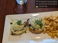
Brunch after @47.5145,-122.3454
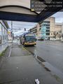
Bus picking me up @47.5794,-122.3289
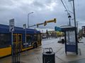
Bus dropping me off

Porches of 201, 202, and 203 @47.5148,-122.3457
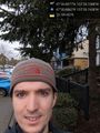
Geohasher @47.5148,-122.3457
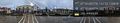
Plaza panorama @47.5145,-122.3450


Achievements