Difference between revisions of "2024-01-01 49 11"
From Geohashing
([live picture]At the hash) |
(categories, format) |
||
| Line 1: | Line 1: | ||
| − | + | {{meetup graticule | |
| − | |||
| − | |||
| − | |||
| − | |||
| − | |||
| − | |||
| − | |||
| − | |||
| lat={{#explode:{{SUBPAGENAME}}| |1}} | | lat={{#explode:{{SUBPAGENAME}}| |1}} | ||
| lon={{#explode:{{SUBPAGENAME}}| |2}} | | lon={{#explode:{{SUBPAGENAME}}| |2}} | ||
| Line 13: | Line 5: | ||
}}<!-- edit as necessary --> | }}<!-- edit as necessary --> | ||
== Location == | == Location == | ||
| − | + | This Geohash is located on a meadow in Painten. | |
== Participants == | == Participants == | ||
| − | + | *[[User:Torodeas|Torodeas]] | |
| − | |||
| − | [[User:Torodeas|Torodeas]] | ||
| − | |||
| − | |||
| − | |||
== Expedition == | == Expedition == | ||
<!-- how it all turned out. your narrative goes here. --> | <!-- how it all turned out. your narrative goes here. --> | ||
| − | |||
| − | |||
| − | |||
== Photos == | == Photos == | ||
| Line 34: | Line 18: | ||
--> | --> | ||
<gallery perrow="5"> | <gallery perrow="5"> | ||
| − | |||
Image:2024-01-01_49_11_Torodeas_1704139580271.jpg|A less than clear path [https://openstreetmap.org/?mlat=49.02153450&mlon=11.84158160&zoom=16 @49.0215,11.8416] | Image:2024-01-01_49_11_Torodeas_1704139580271.jpg|A less than clear path [https://openstreetmap.org/?mlat=49.02153450&mlon=11.84158160&zoom=16 @49.0215,11.8416] | ||
| Line 47: | Line 30: | ||
{{#vardefine:ribbonwidth|100%}} | {{#vardefine:ribbonwidth|100%}} | ||
<!-- Add any achievement ribbons you earned below, or remove this section --> | <!-- Add any achievement ribbons you earned below, or remove this section --> | ||
| + | {{consecutive geohash 3 | ||
| + | | hashcount = 7 | ||
| + | | daycount = 7 | ||
| + | | date = 2023-12-26 | ||
| + | | latitude = 49 | ||
| + | | longitude = 11 | ||
| + | | name = [[User:Torodeas|Torodeas]] | ||
| + | }} | ||
__NOTOC__ | __NOTOC__ | ||
| − | |||
| − | |||
| − | |||
| − | |||
| − | |||
| − | |||
| − | |||
| − | |||
| − | |||
| − | |||
| − | |||
| − | |||
| − | |||
| − | |||
[[Category:Expeditions]] | [[Category:Expeditions]] | ||
| − | |||
[[Category:Expeditions with photos]] | [[Category:Expeditions with photos]] | ||
| − | |||
| − | |||
| − | |||
| − | |||
| − | |||
[[Category:Coordinates reached]] | [[Category:Coordinates reached]] | ||
| − | |||
| − | |||
| − | |||
| − | |||
| − | |||
| − | |||
| − | |||
| − | |||
| − | |||
| − | |||
| − | |||
| − | |||
| − | |||
| − | |||
| − | |||
| − | |||
| − | |||
| − | |||
Revision as of 12:16, 1 March 2024
| Mon 1 Jan 2024 in 49,11: 49.0001178, 11.8192533 geohashing.info google osm bing/os kml crox |
Location
This Geohash is located on a meadow in Painten.
Participants
Expedition
Photos
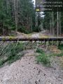
A less than clear path @49.0215,11.8416

Success
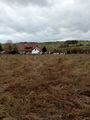
View from the hash
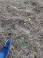
At the hash


Achievements
Torodeas earned the Consecutive geohash achievement
|