Difference between revisions of "2024-01-02 50 10"
([live picture]View from hash) |
(→Achievements) |
||
| (5 intermediate revisions by 3 users not shown) | |||
| Line 1: | Line 1: | ||
| − | + | {{meetup graticule | |
| − | |||
| − | |||
| − | |||
| − | |||
| − | |||
| − | |||
| − | |||
| − | |||
| lat=50 | | lat=50 | ||
| lon=10 | | lon=10 | ||
| date=2024-01-02 | | date=2024-01-02 | ||
| − | }} | + | }} |
== Location == | == Location == | ||
| − | + | This Geohash is located in a forest in Callenberg. | |
== Participants == | == Participants == | ||
| − | + | *[[User:Torodeas|Torodeas]] | |
| − | |||
| − | |||
| − | |||
| − | |||
== Expedition == | == Expedition == | ||
<!-- how it all turned out. your narrative goes here. --> | <!-- how it all turned out. your narrative goes here. --> | ||
| + | Compared to [[ 2024-01-01_49_11 | yesterday ]], this expedition is tame. I didn't really plan for it - 7 consecutive hashes have exhausted me and I was ready to end at that round-ish number. | ||
| + | |||
| + | But today's point is interesting: It's in Coburg. The CITY of Coburg. The bigger Graticule of Coburg, but still. The chance of a hash there still just half a percent: | ||
| + | |||
| + | [[File:Coburg.svg]] | ||
| + | {| class="wikitable" | ||
| + | !Name!!Geohash<br />probability | ||
| + | |- | ||
| + | |<span style="color:rgb(0, 255, 0)">■</span> 50,10||0.51% | ||
| + | |- | ||
| + | |<span style="color:rgb(255, 128, 128)">■</span> 50,11||0.10% | ||
| + | |} | ||
| + | |||
| + | You see, Germany is separated into districts. Most cities are just part of their district, but some cities are so large (or some other historical reason) that they are a district upon themselves, giving a much, much smaller district than otherwise. | ||
| + | If I ever want to complete subdividing [[wikipedia:Upper_Franconia|Upper Franconia]], I will need four of these independent cities: Hof, Bayreuth, Bamberg and Coburg. And today's hash in Coburg is - very accessible. It's close to a train stop, I still have vacation, so I have time to go there, AND they recently build a new high-speed connection between Bamberg & Coburg I will be able to use for this trip. | ||
| − | + | So out I go for this one additional hash. There really isn't anything special to say here, except that the new high-speed rail-link is great, shaving off 30 mins in each direction, and I have approx. 40-45 minutes to cover the 1km from the train station to the hash (and back). That sounds like a lot (and it is), but there is a significant elevation difference between the station and the hash. And my feet hurt after yesterday. But I make it in time (and in a kind of annoyingly cold rain), capture a good reading and turn back to the train station. | |
| − | |||
== Photos == | == Photos == | ||
| − | |||
| − | |||
| − | |||
<gallery perrow="5"> | <gallery perrow="5"> | ||
| − | |||
Image:2024-01-02_50_10_Torodeas_1704218911025.jpg|Coburg Beierssorf train station | Image:2024-01-02_50_10_Torodeas_1704218911025.jpg|Coburg Beierssorf train station | ||
| Line 46: | Line 44: | ||
{{#vardefine:ribbonwidth|100%}} | {{#vardefine:ribbonwidth|100%}} | ||
<!-- Add any achievement ribbons you earned below, or remove this section --> | <!-- Add any achievement ribbons you earned below, or remove this section --> | ||
| + | {{consecutive geohash 3 | ||
| + | | hashcount = 8 | ||
| + | | daycount = 8 | ||
| + | | date = 2023-12-26 | ||
| + | | latitude = 49 | ||
| + | | longitude = 11 | ||
| + | | name = [[User:Torodeas|Torodeas]] | ||
| + | }} | ||
| + | {{land geohash | ||
| − | + | | latitude = 50 | |
| − | + | | longitude = 10 | |
| − | + | | date = 2024-01-02 | |
| − | [[ | + | | name = [[User:Torodeas|Torodeas]] ([[User talk:Torodeas|talk]]) |
| + | |||
| + | }} | ||
| + | {{public transport geohash | ||
| − | + | | latitude = 50 | |
| + | | longitude = 10 | ||
| + | | date = 2024-01-02 | ||
| + | | name = [[User:Torodeas|Torodeas]] ([[User talk:Torodeas|talk]]) | ||
| + | | busline = RB11, RE19, RB18 | ||
| − | + | }} | |
| − | |||
| − | |||
| − | |||
| − | |||
| − | + | __NOTOC__ | |
[[Category:Expeditions]] | [[Category:Expeditions]] | ||
| − | |||
[[Category:Expeditions with photos]] | [[Category:Expeditions with photos]] | ||
| − | |||
| − | |||
| − | |||
| − | |||
| − | |||
[[Category:Coordinates reached]] | [[Category:Coordinates reached]] | ||
| − | + | {{location|DE|BY|CO|city=true}} | |
| − | |||
| − | |||
| − | |||
| − | |||
| − | |||
| − | |||
| − | |||
| − | |||
| − | |||
| − | |||
| − | |||
| − | |||
| − | |||
| − | |||
| − | |||
| − | |||
| − | |||
Latest revision as of 21:36, 5 March 2024
| Tue 2 Jan 2024 in 50,10: 50.2802026, 10.9227301 geohashing.info google osm bing/os kml crox |
Location
This Geohash is located in a forest in Callenberg.
Participants
Expedition
Compared to yesterday , this expedition is tame. I didn't really plan for it - 7 consecutive hashes have exhausted me and I was ready to end at that round-ish number.
But today's point is interesting: It's in Coburg. The CITY of Coburg. The bigger Graticule of Coburg, but still. The chance of a hash there still just half a percent:

| Name | Geohash probability |
|---|---|
| ■ 50,10 | 0.51% |
| ■ 50,11 | 0.10% |
You see, Germany is separated into districts. Most cities are just part of their district, but some cities are so large (or some other historical reason) that they are a district upon themselves, giving a much, much smaller district than otherwise. If I ever want to complete subdividing Upper Franconia, I will need four of these independent cities: Hof, Bayreuth, Bamberg and Coburg. And today's hash in Coburg is - very accessible. It's close to a train stop, I still have vacation, so I have time to go there, AND they recently build a new high-speed connection between Bamberg & Coburg I will be able to use for this trip.
So out I go for this one additional hash. There really isn't anything special to say here, except that the new high-speed rail-link is great, shaving off 30 mins in each direction, and I have approx. 40-45 minutes to cover the 1km from the train station to the hash (and back). That sounds like a lot (and it is), but there is a significant elevation difference between the station and the hash. And my feet hurt after yesterday. But I make it in time (and in a kind of annoyingly cold rain), capture a good reading and turn back to the train station.
Photos
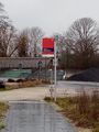
Coburg Beierssorf train station

Proof
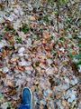
At the hash
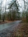
View from hash


Achievements
Torodeas earned the Consecutive geohash achievement
|
Torodeas (talk) earned the Land geohash achievement
|
Torodeas (talk) earned the Public transport geohash achievement
|