Difference between revisions of "2024-02-29 46 -71"
From Geohashing
(Categories) |
|||
| Line 1: | Line 1: | ||
| − | + | {{meetup graticule | |
| − | |||
| − | |||
| − | |||
| − | |||
| − | |||
| − | |||
| − | |||
| − | |||
| lat=46 | | lat=46 | ||
| lon=-71 | | lon=-71 | ||
| Line 29: | Line 21: | ||
[[File:Proof 20240229 gict 3.png|thumb|left|Weather (°C]] Turned out the house had heavy curtain. I parked my car at the stop sign and got out. Weather was bad and I tried to keep myself warm while my watch save my location. I tooked a blur picture of my watch before my phone died from the cold. | [[File:Proof 20240229 gict 3.png|thumb|left|Weather (°C]] Turned out the house had heavy curtain. I parked my car at the stop sign and got out. Weather was bad and I tried to keep myself warm while my watch save my location. I tooked a blur picture of my watch before my phone died from the cold. | ||
| − | |||
| − | |||
| − | |||
== Photos == | == Photos == | ||
| − | |||
| − | |||
| − | |||
<gallery perrow="5"> | <gallery perrow="5"> | ||
Image:Proof 20240229 gict 2.png | Position | Image:Proof 20240229 gict 2.png | Position | ||
Image:Proof 20240229 gict 1.jpg | Watch | Image:Proof 20240229 gict 1.jpg | Watch | ||
</gallery> | </gallery> | ||
| − | |||
| − | |||
__NOTOC__ | __NOTOC__ | ||
| − | |||
| − | |||
| − | |||
| − | |||
| − | |||
| − | |||
| − | |||
| − | |||
| − | |||
| − | |||
| − | |||
| − | |||
[[Category:Expeditions]] | [[Category:Expeditions]] | ||
| − | |||
[[Category:Expeditions with photos]] | [[Category:Expeditions with photos]] | ||
| − | |||
| − | |||
| − | |||
| − | |||
| − | |||
[[Category:Coordinates reached]] | [[Category:Coordinates reached]] | ||
| − | |||
| − | |||
| − | |||
| − | |||
| − | |||
| − | |||
| − | |||
| − | |||
| − | |||
| − | |||
| − | |||
| − | |||
| − | |||
| − | |||
| − | |||
| − | |||
| − | |||
| − | |||
Revision as of 15:15, 8 March 2024
| Thu 29 Feb 2024 in 46,-71: 46.7928141, -71.2361341 geohashing.info google osm bing/os kml crox |
Leap day !
Location
Geohash seems in front of a house in a nice neighborhood.
Participants
Plans
The hash point is a bit far for a walk on lunch hour but the plan is to go after work. I will drive there, the wind and snow are strong today and dont motivate me for attempting to walk.
Expedition
Some things came up and I started my drive to the geohash point around 23h. I was scare that my presence at that late hour we'll bring attention since I didn't know how close to the house I will have to get.

Turned out the house had heavy curtain. I parked my car at the stop sign and got out. Weather was bad and I tried to keep myself warm while my watch save my location. I tooked a blur picture of my watch before my phone died from the cold.
Photos
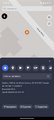
Position
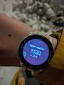
Watch

