Difference between revisions of "Savukoski, Finland"
From Geohashing
imported>ReletBot m (Created inactive graticule page with information from All Graticules, using standard format.) |
m (per Renaming Proposal) |
||
| (13 intermediate revisions by 4 users not shown) | |||
| Line 1: | Line 1: | ||
| + | {{QuickLinks|lat=67|lon=28}} | ||
{{graticule | {{graticule | ||
| lat= 67 | | lat= 67 | ||
| lon= 28 | | lon= 28 | ||
| nw = [[Inari, Finland|Inari]] | | nw = [[Inari, Finland|Inari]] | ||
| − | | n = [[ | + | | n = [[Raja-Jooseppi, Finland| Raja-Jooseppi]] |
| ne = [[68,29]] | | ne = [[68,29]] | ||
| w = [[Pyhäjärvi, Finland|Pyhäjärvi]] | | w = [[Pyhäjärvi, Finland|Pyhäjärvi]] | ||
| name = [[Savukoski, Finland|Savukoski]] | | name = [[Savukoski, Finland|Savukoski]] | ||
| − | | e = [[ | + | | e = [[Värriö, Finland| Värriö]] |
| sw = [[Kemijärvi, Finland|Kemijärvi]] | | sw = [[Kemijärvi, Finland|Kemijärvi]] | ||
| s = [[Salla, Finland|Salla]] | | s = [[Salla, Finland|Salla]] | ||
| − | | se = [[ | + | | se = [[Oulanka, Finland| Oulanka]] |
}} | }} | ||
| − | This graticule is located at [[67,28]]. | + | This graticule is located at [[67,28]]. {{Today's location|lat=67|lon=28}} |
[[Category:Inactive graticules]] [[Category:Finland]] | [[Category:Inactive graticules]] [[Category:Finland]] | ||
| + | |||
| + | [[File:2017-06-20 67 28DSC 0322 1500px.jpg|400px|thumb|left|]] | ||
| + | |||
| + | |||
| + | [http://www.savukoski.fi| Savukoski] is a vast wilderness with rugged hills, wild rivers (biggest of which Kemijoki) and fells, one of which is [http://www.korvatunturi.fi| Korvatunturi], the home of Santa Claus. | ||
| + | Savukoski expands 6447 square kilometers and has the smallest population density of any municipality in Finland with only 0.16 people per square kilometer. The area has ten times more raindeer than people. [http://www.luontoon.fi/urhokekkosenkansallispuisto| Urho Kekkonen National Park] is partly in the Savukoski municipality. 1/3 of the area comprises of different nature conservation areas. | ||
| + | |||
| + | == Local Geohashers == | ||
| + | |||
| + | None | ||
| + | |||
| + | == Meetups == | ||
| + | |||
| + | *1. [[2017-06-20_67_28|2017-06-20]] Reached successfully by [[User:Pastori|Pastori]] and The Wife | ||
| + | |||
| + | == Notable Dates == | ||
| + | |||
| + | {{Graticule unlocked | ||
| + | | latitude = 67 | ||
| + | | longitude = 28 | ||
| + | | date = 2017-06-20 | ||
| + | | name = [[User:Pastori|Pastori]] | ||
| + | | image = 2017-06-20 67 28DSC 0308 1500px.jpg | ||
| + | }} | ||
| + | |||
| + | [[Category:Inactive graticules]] | ||
| + | [[Category:Finland]] | ||
Latest revision as of 03:51, 20 March 2024
|
Latest Coordinates and Map Quick-Links | |
|---|---|
| Sunday 2024-11-24 | 67.3551281, 28.6005570 |
| Monday 2024-11-25 | 67.7269909, 28.9214530 |
| Inari | Raja-Jooseppi | 68,29 |
| Pyhäjärvi | Savukoski | Värriö |
| Kemijärvi | Salla | Oulanka |
|
Today's location: geohashing.info google osm bing/os kml crox | ||
This graticule is located at 67,28. Today's location
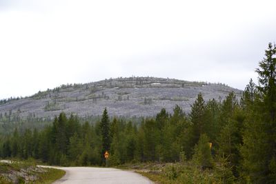
Savukoski is a vast wilderness with rugged hills, wild rivers (biggest of which Kemijoki) and fells, one of which is Korvatunturi, the home of Santa Claus.
Savukoski expands 6447 square kilometers and has the smallest population density of any municipality in Finland with only 0.16 people per square kilometer. The area has ten times more raindeer than people. Urho Kekkonen National Park is partly in the Savukoski municipality. 1/3 of the area comprises of different nature conservation areas.
Local Geohashers
None
Meetups
- 1. 2017-06-20 Reached successfully by Pastori and The Wife
Notable Dates
Pastori earned the Graticule Unlocked Achievement
|
