Difference between revisions of "2018-05-22 -22 -47"
From Geohashing
imported>Copper |
m (per Renaming Proposal) |
||
| (4 intermediate revisions by 3 users not shown) | |||
| Line 20: | Line 20: | ||
== Location == | == Location == | ||
<!-- where you've surveyed the hash to be --> | <!-- where you've surveyed the hash to be --> | ||
| + | The backyard of a government building. | ||
== Participants == | == Participants == | ||
| Line 28: | Line 29: | ||
== Expedition == | == Expedition == | ||
<!-- how it all turned out. your narrative goes here. --> | <!-- how it all turned out. your narrative goes here. --> | ||
| + | After a failed expedition the day before, I was of a mind to try again and was pleasantly surprised to see the hashpoint fall within reach. I took off during lunch for a quick expedition, and managed to hit the hashpoint from the outside the fence. I excitedly grabbed screenshots but forgot to take pictures of the surroundings. Still, I achieved my first geohash and the graticule is now active! | ||
== Photos == | == Photos == | ||
| Line 45: | Line 47: | ||
| − | {{ | + | {{Graticule unlocked |
| latitude = -22 | | latitude = -22 | ||
| Line 60: | Line 62: | ||
| name = [[User: Copper|Copper]] | | name = [[User: Copper|Copper]] | ||
}} | }} | ||
| − | |||
| − | |||
| − | |||
| − | |||
| − | |||
| − | |||
| − | |||
| − | |||
| − | |||
| − | |||
| − | |||
| − | |||
| − | |||
[[Category:Expeditions]] | [[Category:Expeditions]] | ||
| − | |||
| − | |||
| − | |||
| − | |||
| − | |||
| − | |||
| − | |||
[[Category:Coordinates reached]] | [[Category:Coordinates reached]] | ||
| − | + | {{location|BR|SP}} | |
| − | |||
| − | |||
| − | |||
| − | |||
| − | |||
| − | |||
| − | |||
| − | |||
| − | |||
| − | |||
| − | |||
| − | |||
| − | |||
| − | |||
| − | |||
| − | |||
| − | |||
Latest revision as of 04:55, 20 March 2024
| Tue 22 May 2018 in -22,-47: -22.8482716, -47.0409852 geohashing.info google osm bing/os kml crox |
Location
The backyard of a government building.
Participants
Expedition
After a failed expedition the day before, I was of a mind to try again and was pleasantly surprised to see the hashpoint fall within reach. I took off during lunch for a quick expedition, and managed to hit the hashpoint from the outside the fence. I excitedly grabbed screenshots but forgot to take pictures of the surroundings. Still, I achieved my first geohash and the graticule is now active!
Photos
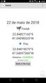
Made it this time!
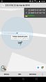
Just across the fence.


Achievements
Copper earned the Graticule Unlocked Achievement
|
Copper earned the Land geohash achievement
|