Difference between revisions of "2016-05-01 34 -116"
imported>AeroIllini (→Expedition) |
m (per Renaming Proposal) |
||
| (9 intermediate revisions by 2 users not shown) | |||
| Line 37: | Line 37: | ||
Multihash achieved! See [[2016-05-01 34 -117]] for the first point. | Multihash achieved! See [[2016-05-01 34 -117]] for the first point. | ||
| + | |||
| + | Virgin Graticule achieved! [[User:AeroIllini|AeroIllini]] had the first recorded geohash Expedition in [[34,-116]]. | ||
== Tracklog == | == Tracklog == | ||
| Line 54: | Line 56: | ||
Image:2016-05-01_34_-116_AeroIllini_1462122003691.jpg|Looking west. [http://www.openstreetmap.org/?lat=34.75659610&lon=-116.15618470&zoom=16&layers=B000FTF @34.7566,-116.1562] | Image:2016-05-01_34_-116_AeroIllini_1462122003691.jpg|Looking west. [http://www.openstreetmap.org/?lat=34.75659610&lon=-116.15618470&zoom=16&layers=B000FTF @34.7566,-116.1562] | ||
| + | |||
| + | Image:2016-05-01_34_-116_AeroIllini_1462131534764.jpg|A sign near the point. | ||
| + | |||
| + | Image:2016-05-01_34_-116_AeroIllini_1462131589314.jpg|Curses! Foiled by sand! | ||
| + | |||
| + | Image:2016-05-01_34_-116_AeroIllini_1462131617806.jpg|Abandoned plank to the rescue! | ||
</gallery> | </gallery> | ||
| Line 60: | Line 68: | ||
<!-- Add any achievement ribbons you earned below, or remove this section --> | <!-- Add any achievement ribbons you earned below, or remove this section --> | ||
| − | + | {{Multihash | |
| − | |||
| − | |||
| − | + | | latitude1 = 34 | |
| − | + | | longitude1 = -117 | |
| − | + | | latitude2 = 34 | |
| − | -- | + | | longitude2 = -116 |
| + | | date = 2016-05-01 | ||
| + | | name = AeroIllini | ||
| + | | image = 2016-05-01_34_-116_AeroIllini_1462121910316.jpg | ||
| + | |||
| + | }} | ||
| + | |||
| + | {{Graticule unlocked | ||
| + | |||
| + | | latitude = 34 | ||
| + | | longitude = -116 | ||
| + | | date = 2016-05-01 | ||
| + | | name = AeroIllini | ||
| + | | image = 2016-05-01_34_-116_AeroIllini_1462131534764.jpg | ||
| − | + | }} | |
| − | |||
[[Category:Expeditions]] | [[Category:Expeditions]] | ||
| − | |||
[[Category:Expeditions with photos]] | [[Category:Expeditions with photos]] | ||
| − | |||
| − | |||
| − | |||
| − | |||
| − | |||
[[Category:Coordinates reached]] | [[Category:Coordinates reached]] | ||
| − | + | {{location|US|CA|SA}} | |
| − | |||
| − | |||
| − | |||
| − | |||
| − | |||
| − | |||
| − | |||
| − | |||
| − | |||
| − | |||
| − | |||
| − | |||
| − | |||
| − | |||
| − | |||
| − | |||
| − | |||
Latest revision as of 05:00, 20 March 2024
| Sun 1 May 2016 in 34,-116: 34.7565890, -116.1561773 geohashing.info google osm bing/os kml crox |
Location
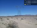
The point is under some high-voltage wires a mile or so north of Ludlow, CA.
Participants
AeroIllini, visiting from Seattle.
Plans
Expedition
AeroIllini arrived in mid-morning to discover that the dirt road leading to the point was a bit sandier than his rental vehicle could handle. Abandoning the stuck car for the moment, the Expedition proceeded to the point on foot. Several photos were taken under the ominous hum of the high-voltage wires.
During the return trip, a wooden plank was discovered on the side of the dirt road. After digging out the sand and jamming the plank under the stuck tire, the vehicle was rocked free and carefully driven back to the comforting embrace of paved roads.
Multihash achieved! See 2016-05-01 34 -117 for the first point.
Virgin Graticule achieved! AeroIllini had the first recorded geohash Expedition in 34,-116.
Tracklog
Photos

Success! @34.7566,-116.1562
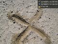
X marks the spot. @34.7566,-116.1562
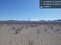
Some of the surrounding countryside, with high voltage power lines buzzing overhead. @34.7566,-116.1562
Looking west. @34.7566,-116.1562
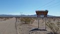
A sign near the point.
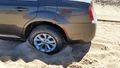
Curses! Foiled by sand!
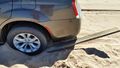
Abandoned plank to the rescue!


Achievements
AeroIllini earned the Multihash Achievement
|
AeroIllini earned the Graticule Unlocked Achievement
|