Difference between revisions of "2015-08-19 36 10"
imported>Dunaril |
m (per Renaming Proposal) |
||
| (11 intermediate revisions by 3 users not shown) | |||
| Line 1: | Line 1: | ||
| + | |||
| + | [[Image:{{{image|Tun2.jpg}}}|thumb|left]] | ||
| − | |||
| − | |||
| − | |||
| − | |||
{{meetup graticule | {{meetup graticule | ||
| lat=36 | | lat=36 | ||
| Line 19: | Line 17: | ||
== Plans == | == Plans == | ||
| − | + | We are visiting Tunisia for the week and just attended a wedding in Hammam-Lif! We were going to drive to Nabeul today so the hash was just 5 minutes away from our expected route. We couldn't turn down such an opportunity to score the first geohash in this graticule (and maybe in Tunisia?) | |
== Expedition == | == Expedition == | ||
| − | + | This went as smoothly as we could hope. We left the highway and parked where the main road crossed the canal we had seen on satellite imagery. We walked for a couple hundred meters and the GeohashDroid helper turned green (closest fix at 4 meters). We took the necessary selfie and went on to the amazing Dar Sabri in Nabeul. | |
| − | == | + | == Photos == |
| − | |||
| − | |||
| − | |||
| − | |||
| − | |||
<gallery perrow="5"> | <gallery perrow="5"> | ||
| + | Image:Tun3.jpg | The canal, 250m from the hash | ||
| + | Image:Tun1.jpg | The canal, close to the hash | ||
| + | Image:Tun2.jpg | Happy, and fighting the heat | ||
| + | Image:Tun4.png | Proof | ||
</gallery> | </gallery> | ||
== Achievements == | == Achievements == | ||
| + | |||
| + | According to [http://home.widicam.net/geohashing/ExpeditionGraticules this map] this is the first successful expedition in Tunisia and the 5th geohash reached in an African country (the 4 others having been all reached in South Africa), but the 10th hash on the African "continent" (5 hashes having been reached in Canary islands). | ||
{{#vardefine:ribbonwidth|800px}} | {{#vardefine:ribbonwidth|800px}} | ||
| − | + | {{land geohash | latitude = 36 | longitude = 10 | date = 2015-08-19 | name = [[User:Dunaril|Dunaril]] and [[User:Katu|Katu]] | image = Tun2.jpg}} | |
| + | {{Graticule unlocked | latitude = 36 | longitude = 10 | date = 2015-08-19 | name = [[User:Dunaril|Dunaril]] and [[User:Katu|Katu]]}} | ||
| − | |||
| − | |||
| − | |||
| − | |||
| − | |||
| − | |||
| − | |||
| − | |||
| − | |||
| − | |||
| − | |||
| − | |||
[[Category:Expeditions]] | [[Category:Expeditions]] | ||
| − | |||
[[Category:Expeditions with photos]] | [[Category:Expeditions with photos]] | ||
| − | |||
| − | |||
| − | |||
| − | |||
| − | |||
[[Category:Coordinates reached]] | [[Category:Coordinates reached]] | ||
| − | + | {{location|TN|21}} | |
| − | |||
| − | |||
| − | |||
| − | |||
| − | |||
| − | |||
| − | |||
| − | |||
| − | |||
| − | |||
| − | |||
| − | |||
| − | |||
| − | |||
| − | |||
| − | |||
| − | |||
Latest revision as of 05:03, 20 March 2024

| Wed 19 Aug 2015 in 36,10: 36.5924958, 10.4890084 geohashing.info google osm bing/os kml crox |
Location
Near or on a small canal close to the city of Grombalia, 40km away from Tunis, Tunisia.
Participants
Plans
We are visiting Tunisia for the week and just attended a wedding in Hammam-Lif! We were going to drive to Nabeul today so the hash was just 5 minutes away from our expected route. We couldn't turn down such an opportunity to score the first geohash in this graticule (and maybe in Tunisia?)
Expedition
This went as smoothly as we could hope. We left the highway and parked where the main road crossed the canal we had seen on satellite imagery. We walked for a couple hundred meters and the GeohashDroid helper turned green (closest fix at 4 meters). We took the necessary selfie and went on to the amazing Dar Sabri in Nabeul.
Photos
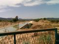
The canal, 250m from the hash
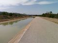
The canal, close to the hash
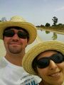
Happy, and fighting the heat
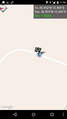
Proof


Achievements
According to this map this is the first successful expedition in Tunisia and the 5th geohash reached in an African country (the 4 others having been all reached in South Africa), but the 10th hash on the African "continent" (5 hashes having been reached in Canary islands).
Dunaril and Katu earned the Land geohash achievement
|
Dunaril and Katu earned the Graticule Unlocked Achievement
|