Difference between revisions of "2015-07-20 54 16"
From Geohashing
imported>Klucken (N) |
m (per Renaming Proposal) |
||
| (6 intermediate revisions by 3 users not shown) | |||
| Line 19: | Line 19: | ||
== Location == | == Location == | ||
| − | + | A place between Łosino and Sierakowo Słupskie, villages in the administrative district of Gmina Kobylnica, [[Słupsk, Poland|Słupsk]] County, Pomeranian Voivodeship, Poland. | |
== Participants == | == Participants == | ||
| − | + | * [[User:Klucken|Klucken]] ([[User talk:Klucken|talk]]) | |
| − | |||
| − | |||
| − | |||
| − | |||
== Expedition == | == Expedition == | ||
| Line 35: | Line 31: | ||
== Photos == | == Photos == | ||
| − | |||
| − | |||
| − | |||
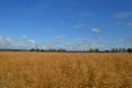
<gallery perrow="5"> | <gallery perrow="5"> | ||
| + | Image:2015-07-20 54 16 coordinates not reached.jpg | only 77 m | ||
| + | Image:2015-07-20 54 16 north.jpg | north | ||
| + | Image:2015-07-20 54 16 west.jpg | west | ||
| + | Image:2015-07-20 54 16 south.jpg | south | ||
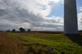
| + | Image:2015-07-20 54 16 east.jpg | east | ||
| + | Image:2015-07-20 54 16 up.jpg | overhead | ||
</gallery> | </gallery> | ||
== Achievements == | == Achievements == | ||
| − | {{ | + | {{Graticule unlocked |
| − | + | | latitude = 54 | |
| − | + | | longitude = 16 | |
| − | + | | date = 2015-07-20 | |
| − | + | | name = Klucken | |
| − | + | }} | |
| − | |||
| − | |||
| − | |||
| − | |||
| − | |||
| − | |||
| − | |||
| − | |||
[[Category:Expeditions]] | [[Category:Expeditions]] | ||
| − | |||
[[Category:Expeditions with photos]] | [[Category:Expeditions with photos]] | ||
| − | |||
| − | |||
| − | |||
| − | |||
| − | |||
| − | |||
| − | |||
| − | |||
| − | |||
[[Category:Coordinates not reached]] | [[Category:Coordinates not reached]] | ||
| − | |||
| − | |||
[[Category:Not reached - Mother Nature]] | [[Category:Not reached - Mother Nature]] | ||
| − | + | {{location|PL|G|SL}} | |
| − | |||
| − | |||
| − | |||
| − | |||
| − | |||
| − | |||
| − | |||
| − | |||
| − | |||
| − | |||
Latest revision as of 05:04, 20 March 2024
| Mon 20 Jul 2015 in 54,16: 54.4023071, 16.9920930 geohashing.info google osm bing/os kml crox |
Location
A place between Łosino and Sierakowo Słupskie, villages in the administrative district of Gmina Kobylnica, Słupsk County, Pomeranian Voivodeship, Poland.
Participants
Expedition
Tracklog
Photos
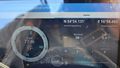
only 77 m
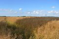
north
west
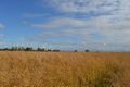
south
east

overhead


Achievements
Klucken earned the Graticule Unlocked Achievement
|