Difference between revisions of "2014-12-01 38 -109"
imported>Michael5000 m (→Location) |
m (per Renaming Proposal) |
||
| (11 intermediate revisions by 2 users not shown) | |||
| Line 22: | Line 22: | ||
== Participants == | == Participants == | ||
| − | |||
| − | |||
| − | + | *[[User:Michael5000|Michael5000]] | |
| − | + | *[[User:Mrs.5000|Mrs.5000]] | |
== Expedition == | == Expedition == | ||
| − | |||
| − | + | From base camp at Mrs.5000's parents' home in western Colorado, we followed I-70 out into the wastes ("Next Services 60 Miles") and then turned south onto lonely Utah route 128. At the historic site of Dewey Bridge, now a ruin after a recent fire, we parked and followed a rough side track up the canyon. About a mile's walk brought us right to the hashpoint. A little extra hiking brought us to some fabulous views of the Colorado River canyon. The day was warm and bright, and lots of sunshine was very welcome to the traveling Oregonians. | |
| − | |||
== Photos == | == Photos == | ||
| − | + | ||
| − | |||
| − | |||
<gallery perrow="5"> | <gallery perrow="5"> | ||
| + | File:2014-12-01 38 -109 bridge.jpg|The ruins of Dewey Bridge, by our parking spot. | ||
| + | File:2014-12-01 38 -109 trail.jpg|The 4x4 road in to the hashpoint from Highway 128. | ||
| + | File:2014-12-01 38 -109 bear.jpg|The bear celebrates his first Utah expedition. | ||
| + | File:2014-12-01 38 -109 panorama 1.jpg|Panorama of the Colorado River from near the hashpoint. | ||
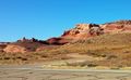
| + | File:2014-12-01 38 -109 panorama 2.jpg|Panorama of the rock formations overlooking the hashpoint. | ||
</gallery> | </gallery> | ||
== Achievements == | == Achievements == | ||
{{#vardefine:ribbonwidth|800px}} | {{#vardefine:ribbonwidth|800px}} | ||
| − | |||
| − | |||
| − | |||
| − | |||
| − | |||
| − | |||
| − | + | {{Graticule unlocked | |
| + | | latitude = 38 | ||
| + | | longitude = -109 | ||
| + | | date = 2014-12-01 | ||
| + | | name = [[User:Michael5000|Michael5000]] and [[User:Mrs.5000|Mrs.5000]] | ||
| + | | image = 2014-12-01 38 -109 bear.jpg | ||
| + | }} | ||
| − | |||
| − | |||
| − | |||
| − | |||
| − | |||
[[Category:Expeditions]] | [[Category:Expeditions]] | ||
| − | |||
[[Category:Expeditions with photos]] | [[Category:Expeditions with photos]] | ||
| − | |||
| − | |||
| − | |||
| − | |||
| − | |||
[[Category:Coordinates reached]] | [[Category:Coordinates reached]] | ||
| − | + | {{location|US|UT|GR}} | |
| − | |||
| − | |||
| − | |||
| − | |||
| − | |||
| − | |||
| − | |||
| − | |||
| − | |||
| − | |||
| − | |||
| − | |||
| − | |||
| − | |||
| − | |||
| − | |||
| − | |||
Latest revision as of 05:07, 20 March 2024
| Mon 1 Dec 2014 in 38,-109: 38.8147425, -109.3148713 geohashing.info google osm bing/os kml crox |
Location
Just off the Kokopelli Trail, about a mile from the Dewey Bridge Campground.
Participants
Expedition
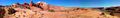
From base camp at Mrs.5000's parents' home in western Colorado, we followed I-70 out into the wastes ("Next Services 60 Miles") and then turned south onto lonely Utah route 128. At the historic site of Dewey Bridge, now a ruin after a recent fire, we parked and followed a rough side track up the canyon. About a mile's walk brought us right to the hashpoint. A little extra hiking brought us to some fabulous views of the Colorado River canyon. The day was warm and bright, and lots of sunshine was very welcome to the traveling Oregonians.
Photos
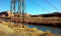
The ruins of Dewey Bridge, by our parking spot.
The 4x4 road in to the hashpoint from Highway 128.
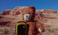
The bear celebrates his first Utah expedition.
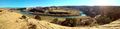
Panorama of the Colorado River from near the hashpoint.
Panorama of the rock formations overlooking the hashpoint.


Achievements
Michael5000 and Mrs.5000 earned the Graticule Unlocked Achievement
|