Difference between revisions of "2014-08-23 41 -75"
imported>Jevanyn ([live] At last, the Holy Grail is in sight!) |
m (per Renaming Proposal) |
||
| (7 intermediate revisions by 2 users not shown) | |||
| Line 18: | Line 18: | ||
__NOTOC__ | __NOTOC__ | ||
== Location == | == Location == | ||
| − | + | Just off Old Mine Rd in Worthington State Park, Hardwick, NJ. | |
== Participants == | == Participants == | ||
| − | + | [[User:Jevanyn|Team Jevanyn]] | |
| − | |||
== Plans == | == Plans == | ||
| − | + | Plans are shaping up to make an activity-filled day of it. Expedition to include geocaching (several nearby, it *is* a park) and playing Ingress (Is there an achievement ribbon for that yet?). | |
== Expedition == | == Expedition == | ||
| − | + | ||
| + | Jeez, where do I start? I'll have to start at the beginning, on Friday morning, at work, discovering that the geohash for Saturday was in the 0/0 decicule. Wait, that's a corner. That's the southeast corner, I might be able to reach the north west graticule ... oh I've been trying to get a geohash there for years! I have to look it up on the map, there's that water treatment plant and stuff, and there's the state park. | ||
| + | |||
| + | |||
| + | Then I saw where the point was, and I don't remember anything else I did at work that day. | ||
| + | |||
| + | |||
| + | It's right on the road, that narrow road along the river, and it's so close to the road, I can reach it, I know it! | ||
*At last, the Holy Grail is in sight! -- [[User:Jevanyn|Jevanyn]] ([[User talk:Jevanyn|talk]]) 09:41, 22 August 2014 (EDT) | *At last, the Holy Grail is in sight! -- [[User:Jevanyn|Jevanyn]] ([[User talk:Jevanyn|talk]]) 09:41, 22 August 2014 (EDT) | ||
| − | == | + | |
| − | + | ||
| + | Gwynnath was excited too. She remembers how much I used to do geohashing when I first started, how I'd look for ones that were in biking distance, or trying to get all the neighboring graticules. But Scranton was a tough one to catch on the New Jersey side. | ||
| + | |||
| + | |||
| + | So we (really she) started planning. A road trip that far afield meant a lot of potential Ingress portals, and a state park means geocaches, too. | ||
| + | |||
| + | |||
| + | We left around 2:30, all four of us. We made a side stop in Glen Gardner to "capture" a historical waypoint or two. We even discovered a park that still had a roundabout (they've gone out of style/favor as a safety hazard), so I took pictures of Gwynnath and Evan riding it, in the rain no less. Gwynnath also hunted down a geocache in the same park. | ||
| + | |||
| + | |||
| + | *Also, found a geocache. (No pictures) -- [[User:Jevanyn|Jevanyn]] ([[User talk:Jevanyn|talk]]) [http://www.openstreetmap.org/?lat=40.70101073&lon=-74.94361831&zoom=16&layers=B000FTF @40.7010,-74.9436] 15:27, 23 August 2014 (EDT) | ||
| + | |||
| + | |||
| + | We then went further up the road and stopped in Oxford, which no one could mistake for its namesake in England, but which had nearly 20 Ingress portals, seemingly ripe for the capture. Grace needed a bathroom break, so I started the assault while Gwynnath took her to a rest room. I thought I had captured one when I realized someone on the other team had re-deployed just as I was about to. And that's when we met Darth Nugget, seven foot tall, wearing a black breathing mask and welding a light saber ... no, not even. He was driving a silver four-door, and just happened to be out defending his home turf. We told him about our crazy adventure of the day, and headed along again. | ||
| + | |||
| + | |||
| + | NJ 31 took us to US 46, which took us to I-80. We were heading for exit 1, the very skinny edge of the state, looking up at the Delaware Water Gap as I drove. I told everyone about Pahaquarry, a town whose name my spell checker will never believe. A town that discorporated about twenty years ago because the population had dropped to a dozen or so people. (Wikipedia has a much better story of it, I'll add a link when I have a chance to polish this write-up.) | ||
| + | |||
| + | |||
| + | And as I take the exit, who gets off the highway right behind me? A bright, neon green New York taxi cab. And driving like one, too, tail gating us for miles on the tiny road in the park, until he finally passed me on the way to the campgrounds. | ||
| + | |||
| + | |||
| + | That obstacle behind, er, ahead of us, we get to the point where I need to find somewhere to put the van while I climb into the woods to the right. Luckily there was a small cutout shoulder on the right side of the road, only a hundred yards or so from the hash point. I parked and started walking ahead, looking for a niche to get into the woods. | ||
| + | |||
| + | |||
| + | I was lucky in that the hash point was not above the stone cuts further back asking the road, but what I was facing seemed formidable enough. The hill a damp, mossy slope, close to a 100% grade at some places. I searched out a gully with a less imposing incline, and started scrambling up into the woods. | ||
| + | |||
| + | |||
| + | Did I mention that I twisted my ankle about two months ago? Every step I had to remind myself +not+ to favor my right ankle, because it would throw off my already poor balance. | ||
| + | |||
| + | |||
| + | Once I got up a few feet, I was able to find a sideways route that was mostly level while still tracking back toward the geohash. I checked my GPS ... and found that I had lost my signal. At this point I had three different apps running: Geohash Droid, which knew where I was going but not where I was; Google Maps, which knew where I was but doesn't display lat/long; and a geocaching app which also wasn't tracking me. I had to determine how far across the hill to back track by dead reckoning. | ||
| + | |||
| + | |||
| + | At this point, I heard Gwynnath call to me from the road. She wanted to climb up as well, in case I fell and couldn't get down by myself. Together, we hiked the rest of the way to the hashpoint, unable to see the van on the side of the road below. He took some celebratory photographs and talked about future camping trips we'd have to make to the same park. | ||
| + | |||
| + | |||
| + | A call from Evan brought us back as quick as we could manage to the van. Grace needed a rest room again, so we drive back to the large campground we'd passed a mile back on our way in. We stopped to look at the river itself, and other campers fishing and such. We even found the campsite where the taxi had been heading. | ||
| + | |||
| + | |||
| + | Before leaving the park, Gwynnath took the girl on a short hike to look for another geocache, but they quickly returned when Gwynnath realized it was a quarter mile from the trail, and it was starting to rain again. | ||
| + | |||
| + | |||
| + | Dinner plans were to head into East Stroudsburg for kid-friendly fare, then start the long drive home. Hot Dog Johnny's was voted down 3 to 1, and hunting around for a kid-friendly restaurant in E. Stroudsburg turned out to be a challenge by itself. We eventually settled for a Friendly's. | ||
| + | |||
| + | |||
| + | A grand adventure was had by all. | ||
| + | |||
| + | |||
| + | |||
== Photos == | == Photos == | ||
| − | + | More coming soon. | |
| − | + | [[Category:Jevanyn/Needs pictures]] | |
| − | |||
<gallery perrow="5"> | <gallery perrow="5"> | ||
| + | |||
| + | Image:2014-08-23_41_-75_jevanyn_1408821121970.jpg | Glen Gardner: we found a park with one of those spinny things that "aren't safe" [http://www.openstreetmap.org/?lat=40.70110000&lon=-74.94360000&zoom=16&layers=B000FTF @40.7011,-74.9436] | ||
</gallery> | </gallery> | ||
== Achievements == | == Achievements == | ||
{{#vardefine:ribbonwidth|800px}} | {{#vardefine:ribbonwidth|800px}} | ||
| − | + | {{Graticule unlocked|name=[[User:Jevanyn|Jevanyn]] ([[User talk:Jevanyn|talk]])|latitude=41|longitude=-75|date=2014-08-23}} | |
| − | |||
| − | |||
| − | |||
| − | |||
| − | |||
| − | |||
| − | |||
| − | |||
| − | |||
| − | |||
| − | |||
[[Category:Expeditions]] | [[Category:Expeditions]] | ||
| − | |||
[[Category:Expeditions with photos]] | [[Category:Expeditions with photos]] | ||
| − | |||
| − | |||
| − | |||
| − | |||
| − | |||
[[Category:Coordinates reached]] | [[Category:Coordinates reached]] | ||
| − | + | {{location|US|NJ|WA}} | |
| − | |||
| − | |||
| − | |||
| − | |||
| − | |||
| − | |||
| − | |||
| − | |||
| − | |||
| − | |||
| − | |||
| − | |||
| − | |||
| − | |||
| − | |||
| − | |||
| − | |||
Latest revision as of 05:09, 20 March 2024
| Sat 23 Aug 2014 in 41,-75: 41.0215872, -75.0584295 geohashing.info google osm bing/os kml crox |
Location
Just off Old Mine Rd in Worthington State Park, Hardwick, NJ.
Participants
Plans
Plans are shaping up to make an activity-filled day of it. Expedition to include geocaching (several nearby, it *is* a park) and playing Ingress (Is there an achievement ribbon for that yet?).
Expedition
Jeez, where do I start? I'll have to start at the beginning, on Friday morning, at work, discovering that the geohash for Saturday was in the 0/0 decicule. Wait, that's a corner. That's the southeast corner, I might be able to reach the north west graticule ... oh I've been trying to get a geohash there for years! I have to look it up on the map, there's that water treatment plant and stuff, and there's the state park.
Then I saw where the point was, and I don't remember anything else I did at work that day.
It's right on the road, that narrow road along the river, and it's so close to the road, I can reach it, I know it!
Gwynnath was excited too. She remembers how much I used to do geohashing when I first started, how I'd look for ones that were in biking distance, or trying to get all the neighboring graticules. But Scranton was a tough one to catch on the New Jersey side.
So we (really she) started planning. A road trip that far afield meant a lot of potential Ingress portals, and a state park means geocaches, too.
We left around 2:30, all four of us. We made a side stop in Glen Gardner to "capture" a historical waypoint or two. We even discovered a park that still had a roundabout (they've gone out of style/favor as a safety hazard), so I took pictures of Gwynnath and Evan riding it, in the rain no less. Gwynnath also hunted down a geocache in the same park.
- Also, found a geocache. (No pictures) -- Jevanyn (talk) @40.7010,-74.9436 15:27, 23 August 2014 (EDT)
We then went further up the road and stopped in Oxford, which no one could mistake for its namesake in England, but which had nearly 20 Ingress portals, seemingly ripe for the capture. Grace needed a bathroom break, so I started the assault while Gwynnath took her to a rest room. I thought I had captured one when I realized someone on the other team had re-deployed just as I was about to. And that's when we met Darth Nugget, seven foot tall, wearing a black breathing mask and welding a light saber ... no, not even. He was driving a silver four-door, and just happened to be out defending his home turf. We told him about our crazy adventure of the day, and headed along again.
NJ 31 took us to US 46, which took us to I-80. We were heading for exit 1, the very skinny edge of the state, looking up at the Delaware Water Gap as I drove. I told everyone about Pahaquarry, a town whose name my spell checker will never believe. A town that discorporated about twenty years ago because the population had dropped to a dozen or so people. (Wikipedia has a much better story of it, I'll add a link when I have a chance to polish this write-up.)
And as I take the exit, who gets off the highway right behind me? A bright, neon green New York taxi cab. And driving like one, too, tail gating us for miles on the tiny road in the park, until he finally passed me on the way to the campgrounds.
That obstacle behind, er, ahead of us, we get to the point where I need to find somewhere to put the van while I climb into the woods to the right. Luckily there was a small cutout shoulder on the right side of the road, only a hundred yards or so from the hash point. I parked and started walking ahead, looking for a niche to get into the woods.
I was lucky in that the hash point was not above the stone cuts further back asking the road, but what I was facing seemed formidable enough. The hill a damp, mossy slope, close to a 100% grade at some places. I searched out a gully with a less imposing incline, and started scrambling up into the woods.
Did I mention that I twisted my ankle about two months ago? Every step I had to remind myself +not+ to favor my right ankle, because it would throw off my already poor balance.
Once I got up a few feet, I was able to find a sideways route that was mostly level while still tracking back toward the geohash. I checked my GPS ... and found that I had lost my signal. At this point I had three different apps running: Geohash Droid, which knew where I was going but not where I was; Google Maps, which knew where I was but doesn't display lat/long; and a geocaching app which also wasn't tracking me. I had to determine how far across the hill to back track by dead reckoning.
At this point, I heard Gwynnath call to me from the road. She wanted to climb up as well, in case I fell and couldn't get down by myself. Together, we hiked the rest of the way to the hashpoint, unable to see the van on the side of the road below. He took some celebratory photographs and talked about future camping trips we'd have to make to the same park.
A call from Evan brought us back as quick as we could manage to the van. Grace needed a rest room again, so we drive back to the large campground we'd passed a mile back on our way in. We stopped to look at the river itself, and other campers fishing and such. We even found the campsite where the taxi had been heading.
Before leaving the park, Gwynnath took the girl on a short hike to look for another geocache, but they quickly returned when Gwynnath realized it was a quarter mile from the trail, and it was starting to rain again.
Dinner plans were to head into East Stroudsburg for kid-friendly fare, then start the long drive home. Hot Dog Johnny's was voted down 3 to 1, and hunting around for a kid-friendly restaurant in E. Stroudsburg turned out to be a challenge by itself. We eventually settled for a Friendly's.
A grand adventure was had by all.
Photos
More coming soon.
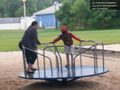
Glen Gardner: we found a park with one of those spinny things that "aren't safe" @40.7011,-74.9436

Achievements
Jevanyn (talk) earned the Graticule Unlocked Achievement
|