Difference between revisions of "2014-03-23 48 3"
imported>Beltxarga (Created page with "{{meetup graticule | lat=48 | lon=3 | date=2014-03-23 }} __NOTOC__ == Location == In a field not too far from Saint-Martin-d'Ablois. == Participants == user:Beltxarga|Bel...") |
m (per Renaming Proposal) |
||
| (5 intermediate revisions by 2 users not shown) | |||
| Line 13: | Line 13: | ||
== Plans == | == Plans == | ||
| − | I spotted this geohash the day before. It was not in my graticule, but quite close (approx. 45 km). And this graticule was still virgin! So I decided to go. On D day, looking at Google Maps, I first planned to park my car in Saint-Martin-d'Ablois, and then walk through the forest to the geohash. But these forests are more or less private and it was a 10 km walk to go there and come back. So I decided to park the car the closest I could, | + | I spotted this geohash the day before. It was not in my graticule, but quite close (approx. 45 km). And this graticule was still virgin! So I decided to go. On D day, looking at Google Maps, I first planned to park my car in Saint-Martin-d'Ablois, and then walk through the forest to the geohash. But these forests are more or less private and it was a 10 km walk to go there and come back. So I decided to park the car the closest I could, on a little road I spotted. I didn't know if that road was also private but I bet it wasn't. |
== Expedition == | == Expedition == | ||
| Line 26: | Line 26: | ||
Image:2014-03-23 48 3 pic4.jpg | A private lake on the left. | Image:2014-03-23 48 3 pic4.jpg | A private lake on the left. | ||
Image:2014-03-23 48 3 pic5.jpg | Here is the field! Gotta go off-road. | Image:2014-03-23 48 3 pic5.jpg | Here is the field! Gotta go off-road. | ||
| + | Image:2014-03-23 48 3 pic6.jpg | The only obstacle I met, a small ditch. | ||
| + | Image:2014-03-23 48 3 pic7.jpg | Best coordinates I could get (4 decimals). | ||
| + | Image:2014-03-23 48 3 pic8.jpg | Around the hash (1). | ||
| + | Image:2014-03-23 48 3 pic9.jpg | Around the hash (2). | ||
| + | Image:2014-03-23 48 3 pic10.jpg | Around the hash (3). | ||
| + | Image:2014-03-23 48 3 pic11.jpg | Around the hash (4). | ||
</gallery> | </gallery> | ||
| Line 38: | Line 44: | ||
}} | }} | ||
| − | {{ | + | {{Graticule unlocked |
| latitude = 48 | | latitude = 48 | ||
| longitude = 3 | | longitude = 3 | ||
| date = 2014-03-23 | | date = 2014-03-23 | ||
| + | | name = Beltxarga | ||
| + | |||
| + | }} | ||
| + | |||
| + | {{Minesweeper geohash | ||
| + | |||
| + | | graticule = Reims, France | ||
| + | | ranknumber = 1 | ||
| + | | sw = true | ||
| name = Beltxarga | | name = Beltxarga | ||
| Line 50: | Line 65: | ||
[[Category:Expeditions with photos]] | [[Category:Expeditions with photos]] | ||
[[Category:Coordinates reached]] | [[Category:Coordinates reached]] | ||
| + | {{location|FR|51}} | ||
Latest revision as of 05:13, 20 March 2024
| Sun 23 Mar 2014 in 48,3: 48.9777937, 3.8069430 geohashing.info google osm bing/os kml crox |
Location
In a field not too far from Saint-Martin-d'Ablois.
Participants
Plans
I spotted this geohash the day before. It was not in my graticule, but quite close (approx. 45 km). And this graticule was still virgin! So I decided to go. On D day, looking at Google Maps, I first planned to park my car in Saint-Martin-d'Ablois, and then walk through the forest to the geohash. But these forests are more or less private and it was a 10 km walk to go there and come back. So I decided to park the car the closest I could, on a little road I spotted. I didn't know if that road was also private but I bet it wasn't.
Expedition
I departed at 12:20 and got some gas for my car. After a painless 40-50 minutes drive, I found the little road, to the left of a larger one. The road wasn't private but it was really just a little path. So from there, I decided to walk. I quickly found the geohash using the Geohash Droid app on my phone (thanks for that!) instead of going in circle looking at my car SatNav like I did on that day. It was a bit too easy, but fun! And it was a virgin graticule! Hooray! Easy was good since it was my first geohash in a few months.
Photos
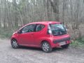
The Geomobile, parked next to the little path.
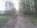
Starting to walk on that path, 800m from the hash.
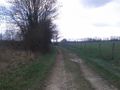
Still walking...
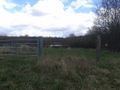
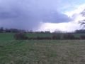
A private lake on the left.
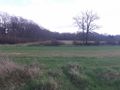
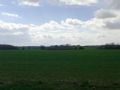
Here is the field! Gotta go off-road.
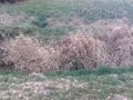
The only obstacle I met, a small ditch.
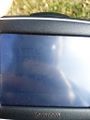
Best coordinates I could get (4 decimals).
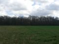
Around the hash (1).
Around the hash (2).
Around the hash (3).
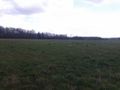
Around the hash (4).


Achievements
Beltxarga earned the Land geohash achievement
|
Beltxarga earned the Graticule Unlocked Achievement
|
Beltxarga achieved level 1 of the Minesweeper Geohash achievement
|