Difference between revisions of "2013-05-27 48 -115"
imported>Vaiman m (→Expedition) |
m (per Renaming Proposal) |
||
| (12 intermediate revisions by 3 users not shown) | |||
| Line 1: | Line 1: | ||
| − | |||
| − | |||
| − | |||
| − | |||
| − | |||
| − | |||
| − | |||
| − | |||
| − | |||
| − | |||
{{meetup graticule | {{meetup graticule | ||
| lat=48 | | lat=48 | ||
| Line 15: | Line 5: | ||
}} | }} | ||
| − | |||
__NOTOC__ | __NOTOC__ | ||
== Location == | == Location == | ||
| − | + | Midway up a mountain slope adjacent to the East Fork of the Yaak River. | |
== Participants == | == Participants == | ||
| Line 24: | Line 13: | ||
== Plans == | == Plans == | ||
| − | #Take Yaak 92 (NF-92) | + | #Take Yaak 92 (NF-92) to the trailhead |
#Follow trail until a point on the opposite ridge of the has is reached | #Follow trail until a point on the opposite ridge of the has is reached | ||
#Bushwhack across steep terrain covered in medium density forest (with at least a single water-crossing) until hash is accomplished | #Bushwhack across steep terrain covered in medium density forest (with at least a single water-crossing) until hash is accomplished | ||
| Line 30: | Line 19: | ||
== Expedition == | == Expedition == | ||
| − | + | Having been randomly given an old GPS receiver last week, I was finally able to embark on my first geohashing excursion. With the advent of the Memorial Day holiday, all excuses were off. After consulting my spreads and topos, the hash coordinates were determined to be in a most opportune location. One must understand, the majority of hashes in my graticule are, quite literally, in the middle of nowhere. While I have no qualms with trekking more miles than is sane through mostly inhospitable, people devouring terrain...I figured this would make an easy first hash. The hash fell on a the opposite side of the drainage paralleled by an old-national-forest-road-turned-hiking-trail. | |
A leisurely morning and a quick pack later, I was on the road toward the trailhead. The paved portion of this journey took me through deep banjo territory and well into Grizzly Bear habitat. I feel it is worth noting, at this point, when planning to hike or geohash in Grizzly Bear country (basically my entire graticule) one should bring at least two of the following items: a large handgun, bear spray, or a slow companion. | A leisurely morning and a quick pack later, I was on the road toward the trailhead. The paved portion of this journey took me through deep banjo territory and well into Grizzly Bear habitat. I feel it is worth noting, at this point, when planning to hike or geohash in Grizzly Bear country (basically my entire graticule) one should bring at least two of the following items: a large handgun, bear spray, or a slow companion. | ||
| Line 36: | Line 25: | ||
Once the trailhead was attained, a quick survey of the area was made. There was a small campsite complete with hitching post nearby. A quick snapshot of the trail sign was snapped before the pack was donned and the real adventure commenced. Though it had been raining intermittently all morning, I left the umbrella within the conveyance since it would be dangerous (though comical) to traverse beyond the trail while wielding a GPS in one hand and umbrella in the other. | Once the trailhead was attained, a quick survey of the area was made. There was a small campsite complete with hitching post nearby. A quick snapshot of the trail sign was snapped before the pack was donned and the real adventure commenced. Though it had been raining intermittently all morning, I left the umbrella within the conveyance since it would be dangerous (though comical) to traverse beyond the trail while wielding a GPS in one hand and umbrella in the other. | ||
| − | The trail itself was | + | The trail itself was easy, with two water crossings; Bridge Creek and Lime Creek, according to my maps. Along the way, I picked up a small white rock (as yet unidentified, likely a type of Quartz) as a trinket from the hash journey. Before I knew it, the GPS indicated I was opposite the river from the hash point. It was time to get serious. As rain began to fall once again, I stepped off the trail into the unknown, descending about one-hundred feet in elevation to the water. This was when my trouble began. The density of the tree cover combined with moving downward into the valley was playing tricks on my receiver. A few small breaks in overhead tree cover allowed brief directional indication until I reached the East Fork. Once there, I lost all satellites except for those directly overhead--and only when I was hanging over the water. Three sat locks are useless when they happen to be directly above you. At this point, I began wandering along both sides of the river, crossing more times than I ever would have cated for, trying to get a lock on one satellite closer to the horizon so I could get a quick bearing. It was then my receiver decided to do magic and calculate my position using two sats directly overhead--accuracy 400+ feet. In addition to this, I made sure to crash through every gigantic spider web along the way. Yelling at satellite #10, I peeled web and arachnids from my body as I made my way back toward the trail to get a better signal. |
Satellite #10 must have heard me, because shortly thereafter I was able to get a fix on my location. Bearing rediscovered, I ran through trees, bushes and more spiders until I was at the same place I first met the river. After a brief pause to appreciate the irony of the situation, I continued eastward and crossed again. With the general area of the point in sight, I raced up the slope until I was within 18 feet. Slowly fanning around, I was able to get to 0.00 feet (~30ft accuracy) before the signal was lost and the unit became confused again. The display now reading that I was twenty feet off, I did a few circles before declaring the tree next to me as ##130527+48,-115. | Satellite #10 must have heard me, because shortly thereafter I was able to get a fix on my location. Bearing rediscovered, I ran through trees, bushes and more spiders until I was at the same place I first met the river. After a brief pause to appreciate the irony of the situation, I continued eastward and crossed again. With the general area of the point in sight, I raced up the slope until I was within 18 feet. Slowly fanning around, I was able to get to 0.00 feet (~30ft accuracy) before the signal was lost and the unit became confused again. The display now reading that I was twenty feet off, I did a few circles before declaring the tree next to me as ##130527+48,-115. | ||
| Line 44: | Line 33: | ||
Difficulty Rating 2/5 | Difficulty Rating 2/5 | ||
Annoyance Rating 3/5 | Annoyance Rating 3/5 | ||
| − | + | Percentage of clothing soaked by rain ~75% | |
| − | |||
| − | |||
== Photos == | == Photos == | ||
| − | |||
| − | |||
| − | |||
<gallery perrow="5"> | <gallery perrow="5"> | ||
| + | Image:130527-20.jpg | The sign at the trailhead. | ||
| + | Image:130527-21.jpg | Hitching post at the trailhead. | ||
| + | Image:130527-11.jpg | East Fork of Yaak River; crossed it more times than I have fingers. | ||
| + | Image:130527-12.jpg | Fighting with satellites. | ||
| + | Image:130527-19.jpg | Tree at hash point. | ||
| + | Image:130527-18.jpg | Blurry confirmation shot of confused GPS. | ||
</gallery> | </gallery> | ||
| − | |||
| − | |||
| − | |||
| − | |||
| − | |||
| − | |||
| − | |||
| − | |||
| − | |||
| − | |||
| − | |||
| − | |||
| − | |||
| − | |||
| − | |||
[[Category:Expeditions]] | [[Category:Expeditions]] | ||
| − | |||
[[Category:Expeditions with photos]] | [[Category:Expeditions with photos]] | ||
| − | |||
| − | |||
| − | |||
| − | |||
| − | |||
[[Category:Coordinates reached]] | [[Category:Coordinates reached]] | ||
| − | + | == Achievements == | |
| − | + | {{#vardefine:ribbonwidth|800px}} | |
| − | + | <!-- Add any achievement ribbons you earned below, or remove this section --> | |
| − | + | {{land geohash | |
| − | + | | latitude = 48 | |
| − | + | | longitude = -115 | |
| − | + | | date = 2013-05-27 | |
| − | + | | name = vaiman | |
| − | + | }} | |
| − | + | {{Graticule unlocked | |
| − | + | | latitude = 48 | |
| − | + | | longitude = -115 | |
| − | + | | date = 2013-05-27 | |
| − | + | | name = vaiman | |
| − | + | }} | |
| − | + | {{location|US|MT|LN}} | |
| − | |||
Latest revision as of 05:24, 20 March 2024
| Mon 27 May 2013 in 48,-115: 48.9264759, -115.4123964 geohashing.info google osm bing/os kml crox |
Location
Midway up a mountain slope adjacent to the East Fork of the Yaak River.
Participants
Plans
- Take Yaak 92 (NF-92) to the trailhead
- Follow trail until a point on the opposite ridge of the has is reached
- Bushwhack across steep terrain covered in medium density forest (with at least a single water-crossing) until hash is accomplished
- Complete previous steps in reverse order
Expedition
Having been randomly given an old GPS receiver last week, I was finally able to embark on my first geohashing excursion. With the advent of the Memorial Day holiday, all excuses were off. After consulting my spreads and topos, the hash coordinates were determined to be in a most opportune location. One must understand, the majority of hashes in my graticule are, quite literally, in the middle of nowhere. While I have no qualms with trekking more miles than is sane through mostly inhospitable, people devouring terrain...I figured this would make an easy first hash. The hash fell on a the opposite side of the drainage paralleled by an old-national-forest-road-turned-hiking-trail.
A leisurely morning and a quick pack later, I was on the road toward the trailhead. The paved portion of this journey took me through deep banjo territory and well into Grizzly Bear habitat. I feel it is worth noting, at this point, when planning to hike or geohash in Grizzly Bear country (basically my entire graticule) one should bring at least two of the following items: a large handgun, bear spray, or a slow companion.
Once the trailhead was attained, a quick survey of the area was made. There was a small campsite complete with hitching post nearby. A quick snapshot of the trail sign was snapped before the pack was donned and the real adventure commenced. Though it had been raining intermittently all morning, I left the umbrella within the conveyance since it would be dangerous (though comical) to traverse beyond the trail while wielding a GPS in one hand and umbrella in the other.
The trail itself was easy, with two water crossings; Bridge Creek and Lime Creek, according to my maps. Along the way, I picked up a small white rock (as yet unidentified, likely a type of Quartz) as a trinket from the hash journey. Before I knew it, the GPS indicated I was opposite the river from the hash point. It was time to get serious. As rain began to fall once again, I stepped off the trail into the unknown, descending about one-hundred feet in elevation to the water. This was when my trouble began. The density of the tree cover combined with moving downward into the valley was playing tricks on my receiver. A few small breaks in overhead tree cover allowed brief directional indication until I reached the East Fork. Once there, I lost all satellites except for those directly overhead--and only when I was hanging over the water. Three sat locks are useless when they happen to be directly above you. At this point, I began wandering along both sides of the river, crossing more times than I ever would have cated for, trying to get a lock on one satellite closer to the horizon so I could get a quick bearing. It was then my receiver decided to do magic and calculate my position using two sats directly overhead--accuracy 400+ feet. In addition to this, I made sure to crash through every gigantic spider web along the way. Yelling at satellite #10, I peeled web and arachnids from my body as I made my way back toward the trail to get a better signal.
Satellite #10 must have heard me, because shortly thereafter I was able to get a fix on my location. Bearing rediscovered, I ran through trees, bushes and more spiders until I was at the same place I first met the river. After a brief pause to appreciate the irony of the situation, I continued eastward and crossed again. With the general area of the point in sight, I raced up the slope until I was within 18 feet. Slowly fanning around, I was able to get to 0.00 feet (~30ft accuracy) before the signal was lost and the unit became confused again. The display now reading that I was twenty feet off, I did a few circles before declaring the tree next to me as ##130527+48,-115.
Since it was pouring rain by this time, I did not unpack my main camera body and tripod for a goofy photo. Instead, I opted to take a blurry screen photo of the GPS before heading back.
Difficulty Rating 2/5 Annoyance Rating 3/5 Percentage of clothing soaked by rain ~75%
Photos
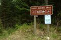
The sign at the trailhead.
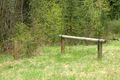
Hitching post at the trailhead.
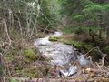
East Fork of Yaak River; crossed it more times than I have fingers.
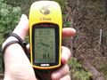
Fighting with satellites.
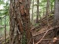
Tree at hash point.
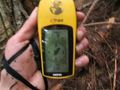
Blurry confirmation shot of confused GPS.


Achievements
vaiman earned the Land geohash achievement
|
vaiman earned the Graticule Unlocked Achievement
|