Difference between revisions of "2013-02-01 33 -95"
imported>SamBurge (Created page with "{{subst:Expedition |lat = 33 |lon = -95 |date = 2013-02-01 }}") |
m (per Renaming Proposal) |
||
| (6 intermediate revisions by 3 users not shown) | |||
| Line 1: | Line 1: | ||
| − | |||
<!-- If you did not specify these parameters in the template, please substitute appropriate values for IMAGE, LAT, LON, and DATE (YYYY-MM-DD format) | <!-- If you did not specify these parameters in the template, please substitute appropriate values for IMAGE, LAT, LON, and DATE (YYYY-MM-DD format) | ||
| Line 15: | Line 14: | ||
}} | }} | ||
| − | + | ||
__NOTOC__ | __NOTOC__ | ||
== Location == | == Location == | ||
| − | + | A field on CO1305, on my old school bus route. | |
== Participants == | == Participants == | ||
| − | + | * [[User:SamBurge|SamBurge]] | |
| − | + | ||
== Plans == | == Plans == | ||
| − | + | Drive out there before heading to Cooper for the weekend. Hope for decent cell phone signal. | |
== Expedition == | == Expedition == | ||
| − | + | It all went very smoothly, which was a shock. I left my home around 3:00pm, hoping to get there before 3:30. Google provided shockingly accurate directions, which proved unnecessary. I drove by a nearby farmhouse at 3:10, and realized where the hash was, and that I'd been by the place at least several thousand times. So I closed out of google maps- quoting the appropriate line from Star Wars, of course- and pulled over at a wide place in the road. | |
| + | |||
| + | Then, disaster! It was in a field full of cows. There weren't any no trespassing signs posted, but I wasn't going to take the chance. So I walked back to the farmhouse I'd passed earlier, and asked after the field. Apparently, the owners lived around half of a mile into the field. I sighed, tightened my shoelaces, and started back to the field, following a gravel path back to the house. | ||
| + | |||
| + | No one was outside, and so I knocked. A rather elderly lady answered the door, and I attempted to explain what I was doing and why I wanted to wander around her property. It was right around 3:20 by this point, and I wanted to get underway. | ||
| + | |||
| + | Eventually, she shrugged and told me I could do as I wanted as long as I didn't bother her cows. So I walked back to the car, and started working the area, fighting some sketchy cell reception every step of the way. At one point, it told me I was within twenty meters of the hash, and then I took a step and it went up to over thirty. Eventually, after around five minutes and an endless number of cow patties stepped in, the reception finally cleared up, and I easily made it to the hash. | ||
| + | |||
| + | BAM. It was on the trail I'd walked on to the house. I'd walked through the hash twice already. Snapped a couple of pictures, hopped back in my car, and was back on the road by 3:30. | ||
| − | |||
| − | |||
== Photos == | == Photos == | ||
| − | + | ||
| − | |||
| − | |||
<gallery perrow="5"> | <gallery perrow="5"> | ||
| + | File:2013-2-1hash.png | Hash reached! | ||
| + | File:2013-02-01_33,_-95_path.jpg | No self picture, but here's one of my shadow! The hash was right around this spot. | ||
| + | File:2013-02-01_15.24.32.jpg | The owner's house. Why do these people have to live so far back? | ||
</gallery> | </gallery> | ||
== Achievements == | == Achievements == | ||
{{#vardefine:ribbonwidth|800px}} | {{#vardefine:ribbonwidth|800px}} | ||
| − | + | {{land geohash | |
| + | | latitude = 33 | ||
| + | | longitude = -95 | ||
| + | | date = 2013-02-01 | ||
| + | | name = SamBurge | ||
| + | }} | ||
| + | {{Graticule unlocked | ||
| + | | latitude = 33 | ||
| + | | longitude = -95 | ||
| + | | date = 2013-02-01 | ||
| + | | name = Sam Burge | ||
| + | | image = 2013-02-01_15.24.32.jpg | ||
| + | }} | ||
| − | |||
| − | |||
| − | |||
| − | + | [[Category:Expeditions]] | |
| − | |||
| − | [[Category: | ||
| − | |||
| − | |||
| − | |||
| − | |||
[[Category:Expeditions with photos]] | [[Category:Expeditions with photos]] | ||
| − | |||
| − | |||
| − | |||
| − | + | ||
[[Category:Coordinates reached]] | [[Category:Coordinates reached]] | ||
| − | + | {{location|US|TX|RV}} | |
| − | |||
| − | |||
| − | |||
| − | |||
| − | |||
| − | |||
| − | |||
| − | |||
| − | |||
| − | |||
| − | |||
| − | |||
| − | |||
| − | |||
| − | |||
| − | |||
| − | |||
Latest revision as of 05:28, 20 March 2024
| Fri 1 Feb 2013 in 33,-95: 33.4950848, -95.1627794 geohashing.info google osm bing/os kml crox |
Location
A field on CO1305, on my old school bus route.
Participants
Plans
Drive out there before heading to Cooper for the weekend. Hope for decent cell phone signal.
Expedition
It all went very smoothly, which was a shock. I left my home around 3:00pm, hoping to get there before 3:30. Google provided shockingly accurate directions, which proved unnecessary. I drove by a nearby farmhouse at 3:10, and realized where the hash was, and that I'd been by the place at least several thousand times. So I closed out of google maps- quoting the appropriate line from Star Wars, of course- and pulled over at a wide place in the road.
Then, disaster! It was in a field full of cows. There weren't any no trespassing signs posted, but I wasn't going to take the chance. So I walked back to the farmhouse I'd passed earlier, and asked after the field. Apparently, the owners lived around half of a mile into the field. I sighed, tightened my shoelaces, and started back to the field, following a gravel path back to the house.
No one was outside, and so I knocked. A rather elderly lady answered the door, and I attempted to explain what I was doing and why I wanted to wander around her property. It was right around 3:20 by this point, and I wanted to get underway.
Eventually, she shrugged and told me I could do as I wanted as long as I didn't bother her cows. So I walked back to the car, and started working the area, fighting some sketchy cell reception every step of the way. At one point, it told me I was within twenty meters of the hash, and then I took a step and it went up to over thirty. Eventually, after around five minutes and an endless number of cow patties stepped in, the reception finally cleared up, and I easily made it to the hash.
BAM. It was on the trail I'd walked on to the house. I'd walked through the hash twice already. Snapped a couple of pictures, hopped back in my car, and was back on the road by 3:30.
Photos
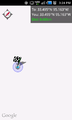
Hash reached!
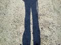
No self picture, but here's one of my shadow! The hash was right around this spot.
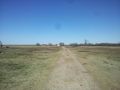
The owner's house. Why do these people have to live so far back?


Achievements
SamBurge earned the Land geohash achievement
|
Sam Burge earned the Graticule Unlocked Achievement
|