Difference between revisions of "2012-11-20 43 28"
From Geohashing
imported>Kisolre m (→Achievements) |
m (per Renaming Proposal) |
||
| (6 intermediate revisions by 2 users not shown) | |||
| Line 1: | Line 1: | ||
| − | |||
<!-- If you did not specify these parameters in the template, please substitute appropriate values for IMAGE, LAT, LON, and DATE (YYYY-MM-DD format) | <!-- If you did not specify these parameters in the template, please substitute appropriate values for IMAGE, LAT, LON, and DATE (YYYY-MM-DD format) | ||
| Line 24: | Line 23: | ||
== Plans == | == Plans == | ||
| − | + | Location seemed reachable and also virgin graticule so too good to miss. | |
== Expedition == | == Expedition == | ||
| − | + | We drove to the nearby wind generator but since the actual hash was in the middle of some freshly plowed field Vania decided to stay in the car. I went to the hash, planted a dead tree and a XKCD sign from some branches (using a foldable knife and of course some blood :) ), took some pictures and headed back. We later went on a walk in the city park and returned home. | |
| − | |||
| − | |||
| − | |||
== Photos == | == Photos == | ||
| Line 39: | Line 35: | ||
Image:2012-11-20_43_28_15-51-09-212.jpg | Proof [http://www.openstreetmap.org/?lat=43.50418028&lon=28.30530826&zoom=16&layers=B000FTF @43.5042,28.3053] | Image:2012-11-20_43_28_15-51-09-212.jpg | Proof [http://www.openstreetmap.org/?lat=43.50418028&lon=28.30530826&zoom=16&layers=B000FTF @43.5042,28.3053] | ||
| + | Image:20121120 43 28 1.jpg | Wind turbine near the hash | ||
| + | Image:20121120 43 28 2.jpg | Forest patch near besides the field | ||
| + | Image:20121120 43 28 3.jpg | The field containing the hash | ||
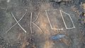
| + | Image:20121120 43 28 4.jpg | Some info for future explorers :) | ||
| + | Image:20121120 43 28 5.jpg | Closer view. | ||
| + | Image:20121120 43 28 6.jpg | [[User:Kisolre|Kisolre]] at the hash. | ||
| + | Image:20121120 43 28 7.jpg | Another view of the wind turbine | ||
</gallery> | </gallery> | ||
| Line 44: | Line 47: | ||
{{#vardefine:ribbonwidth|800px}} | {{#vardefine:ribbonwidth|800px}} | ||
<!-- Add any achievement ribbons you earned below, or remove this section --> | <!-- Add any achievement ribbons you earned below, or remove this section --> | ||
| − | {{ | + | {{Graticule unlocked |
| latitude = 43 | | latitude = 43 | ||
| longitude = 28 | | longitude = 28 | ||
| Line 62: | Line 65: | ||
[[Category:Expeditions with photos]] | [[Category:Expeditions with photos]] | ||
[[Category:Coordinates reached]] | [[Category:Coordinates reached]] | ||
| + | {{location|BG|TX}} | ||
Latest revision as of 05:29, 20 March 2024
| Tue 20 Nov 2012 in 43,28: 43.5041369, 28.3053059 geohashing.info google osm bing/os kml crox |
Location
In a field near Kavarna.
Participants
Kisolre and Vania
Plans
Location seemed reachable and also virgin graticule so too good to miss.
Expedition
We drove to the nearby wind generator but since the actual hash was in the middle of some freshly plowed field Vania decided to stay in the car. I went to the hash, planted a dead tree and a XKCD sign from some branches (using a foldable knife and of course some blood :) ), took some pictures and headed back. We later went on a walk in the city park and returned home.
Photos

Proof @43.5042,28.3053
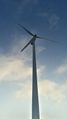
Wind turbine near the hash
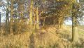
Forest patch near besides the field
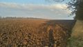
The field containing the hash
Some info for future explorers :)
Closer view.

Kisolre at the hash.
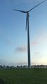
Another view of the wind turbine


Achievements
kisolre earned the Graticule Unlocked Achievement
|
.
Kisolre achieved level 2 of the Minesweeper Geohash achievement
|