Difference between revisions of "2012-09-07 58 8"
From Geohashing
imported>MartinK |
m (per Renaming Proposal) |
||
| (13 intermediate revisions by 6 users not shown) | |||
| Line 1: | Line 1: | ||
| − | |||
| − | |||
| − | |||
| − | |||
| − | |||
| − | |||
| − | |||
| − | |||
| − | |||
{{meetup graticule | {{meetup graticule | ||
| lat=58 | | lat=58 | ||
| Line 17: | Line 8: | ||
__NOTOC__ | __NOTOC__ | ||
== Location == | == Location == | ||
| − | + | In the forest, not far from the Skifjell hill in Lillesand. | |
== Participants == | == Participants == | ||
| − | + | [[User:MartinK|MartinK]] | |
| − | |||
== Plans == | == Plans == | ||
| − | + | The plan was to drive up to Storemyr. Walk from the car to the hash, then walk to the Skifjell hill and back to the car. | |
== Expedition == | == Expedition == | ||
| − | + | This was my first geohash. I walked about 40 minutes from the car to get to the coordinates. Along the way I picked and ate some blueberries. Yummy :-) I took some photos at the site, and then went on a round trip to the Skifjell hill and then back to the car. At home I found a tick that wanted to suck my blood, had to remove it with tweezers. | |
== Tracklog == | == Tracklog == | ||
<!-- if your GPS device keeps a log, you may post a link here --> | <!-- if your GPS device keeps a log, you may post a link here --> | ||
| + | <gallery perrow="5"> | ||
| + | Image:2012-09-07 58 8 Tracklog.jpg|Tracklog. | ||
| + | </gallery> | ||
== Photos == | == Photos == | ||
| Line 37: | Line 30: | ||
--> | --> | ||
<gallery perrow="5"> | <gallery perrow="5"> | ||
| + | Image:2012-09-07_16.08.09.jpg|I found blueberries. | ||
| + | Image:2012-09-07 16.09.18.jpg|Picked some. | ||
| + | Image:2012-09-07 16.11.04.png|Closing in on the geohash. | ||
| + | Image:2012-09-07 16.11.20.jpg|The geohash from afar. | ||
| + | Image:2012-09-07 16.20.18.png|Screenshot from Geohash Droid | ||
| + | Image:IMAG1008.jpg|The GPS device. | ||
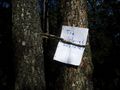
| + | Image:2012-09-07 16.24.30.jpg|The geohash location. | ||
| + | Image:2012-09-07 16.24.49.jpg|The Internet was here! :-) | ||
| + | Image:IMAG1004.jpg |[[User:MartinK|MartinK]] holding the GPS device. | ||
</gallery> | </gallery> | ||
| Line 42: | Line 44: | ||
{{#vardefine:ribbonwidth|800px}} | {{#vardefine:ribbonwidth|800px}} | ||
<!-- Add any achievement ribbons you earned below, or remove this section --> | <!-- Add any achievement ribbons you earned below, or remove this section --> | ||
| + | {{land geohash | latitude = 58 | longitude = 8 | date = 2012-09-07 | name = [[User:MartinK|MartinK]] | image = 2012-09-07 16.09.18.jpg }} | ||
| + | {{Graticule unlocked | latitude = 58 | longitude = 8 | date = 2012-09-07 | name = [[User:MartinK|MartinK]] | image = IMAG1004.jpg }} | ||
| − | + | [[Category:Expeditions with photos]] | |
| − | |||
| − | |||
| − | [[Category: | ||
| − | |||
| − | |||
| − | |||
| − | |||
| − | |||
| − | |||
| − | |||
[[Category:Expeditions]] | [[Category:Expeditions]] | ||
| − | |||
| − | |||
| − | |||
| − | |||
| − | |||
| − | |||
| − | |||
[[Category:Coordinates reached]] | [[Category:Coordinates reached]] | ||
| − | + | [[Category:Expeditions with ticks]] | |
| − | + | {{location|NO|42}} | |
| − | |||
| − | [[Category: | ||
| − | |||
| − | |||
| − | |||
| − | |||
| − | |||
| − | |||
| − | |||
| − | |||
| − | |||
| − | |||
| − | |||
| − | |||
| − | |||
| − | |||
Latest revision as of 05:32, 20 March 2024
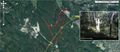
| Fri 7 Sep 2012 in 58,8: 58.2626457, 8.3186415 geohashing.info google osm bing/os kml crox |
Location
In the forest, not far from the Skifjell hill in Lillesand.
Participants
Plans
The plan was to drive up to Storemyr. Walk from the car to the hash, then walk to the Skifjell hill and back to the car.
Expedition
This was my first geohash. I walked about 40 minutes from the car to get to the coordinates. Along the way I picked and ate some blueberries. Yummy :-) I took some photos at the site, and then went on a round trip to the Skifjell hill and then back to the car. At home I found a tick that wanted to suck my blood, had to remove it with tweezers.
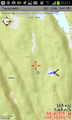
Tracklog
Tracklog.

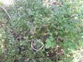
Photos
I found blueberries.
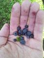
Picked some.
Closing in on the geohash.
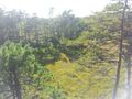
The geohash from afar.
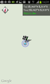
Screenshot from Geohash Droid
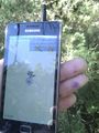
The GPS device.
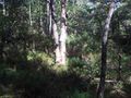
The geohash location.
The Internet was here! :-)
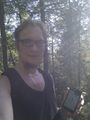
MartinK holding the GPS device.


Achievements
MartinK earned the Land geohash achievement
|
MartinK earned the Graticule Unlocked Achievement
|