Difference between revisions of "2012-08-18 40 -124"
From Geohashing
imported>Kydlt |
m (per Renaming Proposal) |
||
| (2 intermediate revisions by 2 users not shown) | |||
| Line 31: | Line 31: | ||
</gallery> | </gallery> | ||
| − | {{ | + | {{Graticule unlocked |
| − | | latitude = | + | | latitude = 40 |
| − | | longitude = - | + | | longitude = -124 |
| − | | date = 2012- | + | | date = 2012-08-18 |
| name = [[User:Kydlt|Kydlt]] | | name = [[User:Kydlt|Kydlt]] | ||
}} | }} | ||
| Line 42: | Line 42: | ||
[[Category:Expeditions with photos]] | [[Category:Expeditions with photos]] | ||
[[Category:Coordinates reached]] | [[Category:Coordinates reached]] | ||
| + | {{location|US|CA|HU}} | ||
Latest revision as of 05:32, 20 March 2024
| Sat 18 Aug 2012 in 40,-124: 40.5667700, -124.1539128 geohashing.info google osm bing/os kml crox |
Location
The Eel River flood plain / upper beach.
Participants
Plans
In Eureka on business. If I finish I will run down before dark. Maybe a virgin graticule, I gotta research it some more.
Expedition
Strangest, saddest hash ever. On the way to the hash, I ran into a search and rescue team. A young autistic woman went missing that afternoon. So I documented the hash and wandered the shrubs and dunes looking for a lost young woman. I hope they find her. I quit at dark.
Tracklog
maybe later
Photos
more when I get them off the ipad.
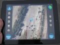
track in.
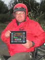
Deputy. I need to find his name.
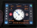
It says 9 ft off, but 16 foot accuracy (previous screen).


Kydlt earned the Graticule Unlocked Achievement
|
If this isn't true, please let me know. There is a fuzzy report "Rouenpucelle tried her first expedition on 1/5/12" that I think was a fail.