Difference between revisions of "2012-07-21 59 14"
imported>Cjk ([live picture] [http://www.openstreetmap.org/?lat=59.04200000&lon=14.40420000&zoom=16&layers=B000FTF @59.0420,14.4042]) |
m (per Renaming Proposal) |
||
| (11 intermediate revisions by 2 users not shown) | |||
| Line 1: | Line 1: | ||
| − | + | [[Image:{{{image|2012-07-21_59_14_13-21-03-512.jpg}}}|thumb|left]] | |
| − | |||
| − | |||
| − | |||
| − | |||
| − | |||
| − | |||
{{meetup graticule | {{meetup graticule | ||
| lat=59 | | lat=59 | ||
| Line 19: | Line 13: | ||
== Location == | == Location == | ||
<!-- where you've surveyed the hash to be --> | <!-- where you've surveyed the hash to be --> | ||
| + | In the Woods NW of Laxå. | ||
== Participants == | == Participants == | ||
<!-- who attended: If you link to your wiki user name in this section, your expedition will be picked up by the various statistics generated for geohashing. You may use three tildes ~ as a shortcut to automatically insert the user signature of the account you are editing with. | <!-- who attended: If you link to your wiki user name in this section, your expedition will be picked up by the various statistics generated for geohashing. You may use three tildes ~ as a shortcut to automatically insert the user signature of the account you are editing with. | ||
--> | --> | ||
| + | [[User:Cjk|Cjk]] | ||
== Plans == | == Plans == | ||
<!-- what were the original plans --> | <!-- what were the original plans --> | ||
| + | I was heading to Varhem in Västergötland to paint the roof of my Granddad's old house. This was just a small detour on the way. | ||
== Expedition == | == Expedition == | ||
<!-- how it all turned out. your narrative goes here. --> | <!-- how it all turned out. your narrative goes here. --> | ||
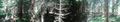
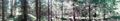
| + | Hopped in the car in the morning and started the drive. As I got to Laxå I turned off the E20 highway and Google Navigate lead me onto what felt like a rally special stage. As the gravel road ended I followed a patch of fairly young and thick planted trees, pines I think. Got a bit further into the woods and got very close to hash. It was in an area of much older and less dense tall trees. As usual tall trees mess with the GPS in the phone but I was sometimes to the East and sometimes to the West of the spot so I averaged in the middle and took some pics. | ||
| + | |||
| + | A very nice sunny day. Saw some mushrooms, but decided not to risk poisoning by eating them. | ||
| + | Walked back to the car and drove the rest of the way and got in the skylift and started grinding away the rust so I could paint it the next day. | ||
*Deflowered -- [[User:Cjk|Cjk]] [http://www.openstreetmap.org/?lat=59.04206308&lon=14.40414503&zoom=16&layers=B000FTF @59.0421,14.4041] 13:15, 21 July 2012 (CEST) | *Deflowered -- [[User:Cjk|Cjk]] [http://www.openstreetmap.org/?lat=59.04206308&lon=14.40414503&zoom=16&layers=B000FTF @59.0421,14.4041] 13:15, 21 July 2012 (CEST) | ||
| Line 48: | Line 49: | ||
Image:2012-07-21_59_14_13-21-03-512.jpg | [http://www.openstreetmap.org/?lat=59.04200000&lon=14.40420000&zoom=16&layers=B000FTF @59.0420,14.4042] | Image:2012-07-21_59_14_13-21-03-512.jpg | [http://www.openstreetmap.org/?lat=59.04200000&lon=14.40420000&zoom=16&layers=B000FTF @59.0420,14.4042] | ||
| + | |||
| + | Image:2012-07-21_59_14_13-21-38-651.jpg | Shrooms [http://www.openstreetmap.org/?lat=59.04200000&lon=14.40430000&zoom=16&layers=B000FTF @59.0420,14.4043] | ||
| + | |||
| + | Image:2012-07-21_59_14_13-22-13-463.jpg | | ||
| + | |||
| + | Image:2012-07-21_59_14_13-22-35-434.jpg | | ||
| + | |||
| + | Image:2012-07-21_59_14_13-22-55-848.jpg | | ||
| + | |||
| + | Image:2012-07-21_59_14_13-23-15-902.jpg | | ||
| + | |||
| + | Image:2012-07-21_59_14_13-23-40-290.jpg | [http://www.openstreetmap.org/?lat=59.04220000&lon=14.40430000&zoom=16&layers=B000FTF @59.0422,14.4043] | ||
| + | |||
| + | Image:2012-07-21_59_14_13-24-02-027.jpg | Marker [http://www.openstreetmap.org/?lat=59.04220000&lon=14.40420000&zoom=16&layers=B000FTF @59.0422,14.4042] | ||
| + | |||
| + | Image:2012-07-21_59_14_13-24-22-980.jpg | [http://www.openstreetmap.org/?lat=59.04210000&lon=14.40430000&zoom=16&layers=B000FTF @59.0421,14.4043] | ||
</gallery> | </gallery> | ||
| Line 53: | Line 70: | ||
{{#vardefine:ribbonwidth|800px}} | {{#vardefine:ribbonwidth|800px}} | ||
<!-- Add any achievement ribbons you earned below, or remove this section --> | <!-- Add any achievement ribbons you earned below, or remove this section --> | ||
| − | + | {{Graticule unlocked | latitude = 59 | longitude = 14 | date = 2012-07-21 | name = [[User:Cjk|Carl-Johan]] | image = 2012-07-21_59_14_13-21-03-512.jpg }} | |
<!-- =============== USEFUL CATEGORIES FOLLOW ================ | <!-- =============== USEFUL CATEGORIES FOLLOW ================ | ||
Delete the next line ONLY if you have chosen the appropriate categories below. If you are unsure, don't worry. People will read your report and help you with the classification. --> | Delete the next line ONLY if you have chosen the appropriate categories below. If you are unsure, don't worry. People will read your report and help you with the classification. --> | ||
| − | [[Category: | + | [[Category:Expeditions]] |
| − | + | [[Category:Coordinates reached]] | |
| − | |||
| − | |||
| − | |||
| − | |||
| − | |||
| − | [[Category: | ||
| − | |||
[[Category:Expeditions with photos]] | [[Category:Expeditions with photos]] | ||
| − | + | {{location|SE|T}} | |
| − | |||
| − | |||
| − | |||
| − | |||
| − | |||
| − | |||
| − | |||
| − | |||
| − | |||
| − | |||
| − | |||
| − | |||
| − | |||
| − | |||
| − | |||
| − | |||
| − | |||
| − | |||
| − | |||
| − | |||
| − | |||
| − | |||
| − | |||
Latest revision as of 05:35, 20 March 2024

| Sat 21 Jul 2012 in 59,14: 59.0420860, 14.4041931 geohashing.info google osm bing/os kml crox |
Location
In the Woods NW of Laxå.
Participants
Plans
I was heading to Varhem in Västergötland to paint the roof of my Granddad's old house. This was just a small detour on the way.
Expedition
Hopped in the car in the morning and started the drive. As I got to Laxå I turned off the E20 highway and Google Navigate lead me onto what felt like a rally special stage. As the gravel road ended I followed a patch of fairly young and thick planted trees, pines I think. Got a bit further into the woods and got very close to hash. It was in an area of much older and less dense tall trees. As usual tall trees mess with the GPS in the phone but I was sometimes to the East and sometimes to the West of the spot so I averaged in the middle and took some pics.
A very nice sunny day. Saw some mushrooms, but decided not to risk poisoning by eating them.
Walked back to the car and drove the rest of the way and got in the skylift and started grinding away the rust so I could paint it the next day.
- Deflowered -- Cjk @59.0421,14.4041 13:15, 21 July 2012 (CEST)
Tracklog
Photos
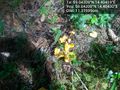
Shrooms @59.0420,14.4043


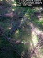
Marker @59.0422,14.4042


Achievements
Carl-Johan earned the Graticule Unlocked Achievement
|