Difference between revisions of "2012-03-06 62 18"
imported>Penthok (Created page with "{{subst:Expedition |lat = 62 |lon = 18 |date = 2012-03-06 }}") |
m (per Renaming Proposal) |
||
| (3 intermediate revisions by 3 users not shown) | |||
| Line 1: | Line 1: | ||
| + | [[Image:{{{image|2012-03-06_62_18_-_P3_-_Hashpoint.JPG}}}|thumb|left]] | ||
| − | |||
| − | |||
| − | |||
| − | |||
| − | |||
| − | |||
| − | |||
| − | |||
| − | |||
{{meetup graticule | {{meetup graticule | ||
| lat=62 | | lat=62 | ||
| Line 19: | Line 11: | ||
== Location == | == Location == | ||
<!-- where you've surveyed the hash to be --> | <!-- where you've surveyed the hash to be --> | ||
| + | According to Google Earth, the hash was a little bit from a road across a meadow, just inside the forest. | ||
== Participants == | == Participants == | ||
<!-- who attended --> | <!-- who attended --> | ||
| + | *[[User:Penthok|Penthok]] | ||
== Plans == | == Plans == | ||
<!-- what were the original plans --> | <!-- what were the original plans --> | ||
| + | Seeing as the hash seemed to have ended up in an easy-to-reach location, I researched buses and found out I could take a bus there, so I decided to make a try. | ||
== Expedition == | == Expedition == | ||
<!-- how it all turned out. your narrative goes here. --> | <!-- how it all turned out. your narrative goes here. --> | ||
| + | Setting out in the early morning I walked over to the bus station and asked for a ticket to Lidebro, which made the bus driver give me a confused look, but after he consulted his book of bus stops I had my ticket and was on the way. | ||
| + | |||
| + | After a bit of journey, I arrived in Lunde where I had to change buses. I used the half hour-ish I had to take a walk in the frozen morning, before getting on the second bus. While on the second bus I saw a fox lurking around a field! Talking to the bus driver, I found out if was a rare occurence for people to depart at my "stop". I also found out there was no physical stop, I just had to tell where I wanted to get off so I got off at a crossroads slightly past the actual point. | ||
| + | |||
| + | Before making it to the point, I scaled a nearby mountain for fun, due to having a lot of time until going home. Unfortunately, the road did not lead to the peak so I missed out on potentially awesome view and walked down again to get to the hash. | ||
| + | |||
| + | So then I walked up the snow-covered road to the meadow, sinking down into the half-metre snow cover and took out my direction. My GPS device refused to work properly and show where I were, so I had to make do with my printed out air photo of the location. Taking out my direction, I headed over across the meadow and made my way into the forest. Due to no exact positioning, I may have been a few metres off, but I should have at least walked across the point when getting to the location of the photo. | ||
| + | |||
| + | Being happy with my success I set back home, walking back to the village of Torrom where I got a bit of a wait for the bus home. So I sat down on the stairs of the church and enjoyed the sun, having the caretaker walk up to me and we had a bit of a conversation about Geohashing and related activities. He did know that there were people doing this kind of stuff at least. After a bus trip back, I spent another 30 minutes in Lunde taking a walk over to the house where my mother grew up. Then, after making it back to my home town, I celebrated by eating a burger at Frasses before walking the final stretch home. | ||
== Tracklog == | == Tracklog == | ||
<!-- if your GPS device keeps a log, you may post a link here --> | <!-- if your GPS device keeps a log, you may post a link here --> | ||
| + | GPS device failure, no log exists. | ||
== Photos == | == Photos == | ||
| − | <!-- Insert pictures between the gallery tags using the following format: | + | <!-- Insert pictures between the gallery tags using the following format: --> |
| − | Image: | + | <gallery perrow="4"> |
| − | -- | + | Image:2012-03-06_62_18_-_P1_-_Crossroads.JPG| After getting off the bus, about 1km away from hashpoint. |
| − | + | Image:2012-03-06_62_18_-_P2_-_Meadow.JPG| Looking across the meadow towards the hashpoint, making care not to disturb the UFO eggs. | |
| + | Image:2012-03-06_62_18_-_P3_-_Hashpoint.JPG| The hashpoint! Being inside the thick sliver of forest. | ||
| + | Image:2012-03-06_62_18_-_P4_-_Map.JPG| The map I used, showing location of hashpoint. | ||
| + | Image:2012-03-06_62_18_-_P5_-_Zoomed_out.JPG| My supplies next to the hashpoint. I forgot to take a picture of me. | ||
| + | Image:2012-03-06_62_18_-_P6_-_Floppies.JPG| Omg! Brand new floppies for sale! | ||
| + | Image:2012-03-06_62_18_-_P7_-_Bus.JPG| The second bus used to reach the geohash. | ||
</gallery> | </gallery> | ||
| Line 42: | Line 52: | ||
{{#vardefine:ribbonwidth|800px}} | {{#vardefine:ribbonwidth|800px}} | ||
<!-- Add any achievement ribbons you earned below, or remove this section --> | <!-- Add any achievement ribbons you earned below, or remove this section --> | ||
| + | {{land geohash | ||
| + | |||
| + | | latitude = 62 | ||
| + | | longitude = 18 | ||
| + | | date = 2012-03-06 | ||
| + | | name = Penthok | ||
| + | |||
| + | }} | ||
| + | |||
| + | {{Public transport geohash | ||
| + | |||
| + | | latitude = 62 | ||
| + | | longitude = 18 | ||
| + | | date = 2012-03-06 | ||
| + | | busline = Din Tur Buses 90 and 228 | ||
| + | | name = Penthok | ||
| + | |||
| + | }} | ||
| + | |||
| + | {{No_batteries_geohash | ||
| + | |||
| + | | latitude = 62 | ||
| + | | longitude = 18 | ||
| + | | date = 2012-03-06 | ||
| + | | name = Penthok | ||
| + | |||
| + | }} | ||
| + | |||
| + | {{Graticule unlocked | ||
| + | |||
| + | | latitude = 62 | ||
| + | | longitude = 18 | ||
| + | | date = 2012-03-06 | ||
| + | | name = Penthok | ||
| + | |||
| + | }} | ||
| + | |||
| + | {{gratuitous ribbon | ||
| + | | color = silver | ||
| + | | icon = TimeTravel.PNG | ||
| + | | latitude = 62 | ||
| + | | longitude = 18 | ||
| + | | date = 2012-03-06 | ||
| + | | achievement = Accidental time-traveller achievement | ||
| + | | description = taking the public DeLorean bus service back to the time when they sold floppies in supermarkets while attempting to reach the | ||
| + | | name = [[User:Penthok|Penthok]] | ||
| + | | image = 2012-03-06_62_18_-_P6_-_Floppies.JPG | ||
| + | }} | ||
<!-- =============== USEFUL CATEGORIES FOLLOW ================ | <!-- =============== USEFUL CATEGORIES FOLLOW ================ | ||
Delete the next line ONLY if you have chosen the appropriate categories below. If you are unsure, don't worry. People will read your report and help you with the classification. --> | Delete the next line ONLY if you have chosen the appropriate categories below. If you are unsure, don't worry. People will read your report and help you with the classification. --> | ||
| − | |||
| − | |||
| − | |||
| − | |||
| − | |||
| − | |||
| − | |||
[[Category:Expeditions]] | [[Category:Expeditions]] | ||
| − | |||
[[Category:Expeditions with photos]] | [[Category:Expeditions with photos]] | ||
| − | [[Category:Expeditions with videos]] | + | <!-- [[Category:Expeditions with videos]] --> |
| − | [[Category:Expedition without GPS]] | + | [[Category:Expedition without GPS]] |
| − | |||
| − | |||
| − | |||
[[Category:Coordinates reached]] | [[Category:Coordinates reached]] | ||
| − | + | {{location|SE|Y}} | |
| − | |||
| − | |||
| − | |||
| − | |||
| − | |||
| − | |||
| − | |||
| − | |||
| − | |||
Latest revision as of 05:44, 20 March 2024

| Tue 6 Mar 2012 in 62,18: 62.8664696, 18.1576538 geohashing.info google osm bing/os kml crox |
Location
According to Google Earth, the hash was a little bit from a road across a meadow, just inside the forest.
Participants
Plans
Seeing as the hash seemed to have ended up in an easy-to-reach location, I researched buses and found out I could take a bus there, so I decided to make a try.
Expedition
Setting out in the early morning I walked over to the bus station and asked for a ticket to Lidebro, which made the bus driver give me a confused look, but after he consulted his book of bus stops I had my ticket and was on the way.
After a bit of journey, I arrived in Lunde where I had to change buses. I used the half hour-ish I had to take a walk in the frozen morning, before getting on the second bus. While on the second bus I saw a fox lurking around a field! Talking to the bus driver, I found out if was a rare occurence for people to depart at my "stop". I also found out there was no physical stop, I just had to tell where I wanted to get off so I got off at a crossroads slightly past the actual point.
Before making it to the point, I scaled a nearby mountain for fun, due to having a lot of time until going home. Unfortunately, the road did not lead to the peak so I missed out on potentially awesome view and walked down again to get to the hash.
So then I walked up the snow-covered road to the meadow, sinking down into the half-metre snow cover and took out my direction. My GPS device refused to work properly and show where I were, so I had to make do with my printed out air photo of the location. Taking out my direction, I headed over across the meadow and made my way into the forest. Due to no exact positioning, I may have been a few metres off, but I should have at least walked across the point when getting to the location of the photo.
Being happy with my success I set back home, walking back to the village of Torrom where I got a bit of a wait for the bus home. So I sat down on the stairs of the church and enjoyed the sun, having the caretaker walk up to me and we had a bit of a conversation about Geohashing and related activities. He did know that there were people doing this kind of stuff at least. After a bus trip back, I spent another 30 minutes in Lunde taking a walk over to the house where my mother grew up. Then, after making it back to my home town, I celebrated by eating a burger at Frasses before walking the final stretch home.
Tracklog
GPS device failure, no log exists.
Photos
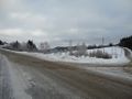
After getting off the bus, about 1km away from hashpoint.
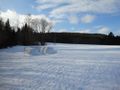
Looking across the meadow towards the hashpoint, making care not to disturb the UFO eggs.
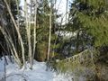
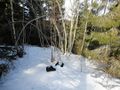
The hashpoint! Being inside the thick sliver of forest.
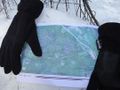
The map I used, showing location of hashpoint.
My supplies next to the hashpoint. I forgot to take a picture of me.
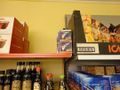
Omg! Brand new floppies for sale!
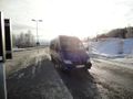
The second bus used to reach the geohash.


Achievements
Penthok earned the Land geohash achievement
|
Penthok earned the Public transport geohash achievement
|
Penthok earned the No Batteries Geohash Achievement
|
Penthok earned the Graticule Unlocked Achievement
|
Penthok earned the Accidental time-traveller achievement
|