Difference between revisions of "2011-05-25 40 16"
imported>Batuffolo (→Photos) |
m (per Renaming Proposal) |
||
| (18 intermediate revisions by 4 users not shown) | |||
| Line 1: | Line 1: | ||
| − | |||
| − | |||
| − | |||
| − | |||
| − | |||
| − | |||
| − | |||
| − | |||
| − | |||
{{meetup graticule | {{meetup graticule | ||
| lat=40 | | lat=40 | ||
| Line 14: | Line 5: | ||
}} | }} | ||
| − | |||
__NOTOC__ | __NOTOC__ | ||
== Location == | == Location == | ||
| − | |||
Today's location is in a field between Casamassima,Bari and Turi,Bari. | Today's location is in a field between Casamassima,Bari and Turi,Bari. | ||
| Line 23: | Line 12: | ||
== Participants == | == Participants == | ||
| − | |||
*[[User:Batuffolo|Batuffolo]] | *[[User:Batuffolo|Batuffolo]] | ||
*my uncle | *my uncle | ||
| Line 29: | Line 17: | ||
== Expedition == | == Expedition == | ||
| − | + | After getting about 600 meters from the hash point by car, me, my uncle (who I used to drive me to the point) and my cousin (we picked him up on the way) were ready to begin the true adventure by entering a big empty field. So we walked through this (and our feet got covered with some strange annoying kind of plants...what a pain!) Then we went to a rusty fence: I felt demoralized! But we couldn't stop there. We managed to climb over it. We were excited. I don't know why we were excited...in the end we were in the middle of a deserted field enclosed by a rusty fence. But we were excited and so we started running towards the gps arrow through a vineyard. Eventually we had to kneel in order to reach the hash point. After being maddened trying to find the exact spot we found it. We took some photos, including a "stylish" one (stylish is a very badly definied term...). On the way back a melancholy sunset welcomed us and we were all sad to leave that adventure. This it has been my first time(and I hope it won't be the last one)and i won't ever forget it. | |
| − | After | ||
| − | This it has been my first time(and | ||
== Photos == | == Photos == | ||
| − | |||
| − | |||
| − | |||
<gallery perrow="5"> | <gallery perrow="5"> | ||
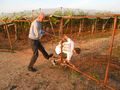
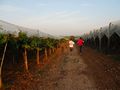
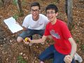
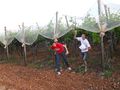
Image:2011-05-25 40 16 field.jpg | me and my uncle in the field | Image:2011-05-25 40 16 field.jpg | me and my uncle in the field | ||
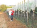
| + | Image:2011-05-25 40 16 cousin.jpg | my "crazy"cousin and my uncle before entering the field | ||
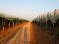
| + | Image:2011-05-25 40 16 field2.jpg | so this is the field... | ||
| + | Image:2011-05-25 40 16 following.jpg | following the gps | ||
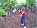
| + | Image:2011-05-25 40 16 cherries.jpg | there were some cherry tree,and i was a little bit hungry... | ||
| + | Image:2011-05-25 40 16 fence.jpg | at the end of the field there was this fence:but nobody could stop us! | ||
| + | Image:2011-05-25 40 16 trespassing.jpg | my cousin entering the fence.i've also entered in this way,but i was taking photos | ||
| + | Image: 2011-05-25 40 16 climbing.jpg | my uncle jumping over the fence... | ||
| + | Image: 2011-05-25 40 16 path.jpg | after having climbed over the fence,this was the path which ran along two wings of trees. | ||
| + | Image: 2011-05-25 40 16 running.jpg | here we started running as we were very near the spot | ||
| + | Image: 2011-05-25 40 16 running2.jpg | we were tunning...oh,have i already told you? | ||
| + | Image: 2011-05-25 40 16 verynear.jpg | we were very near...but we had to go under the trees | ||
| + | Image: 2011-05-25 40 16 underthetrees.jpg | let's go inside,man! | ||
| + | Image: 2011-05-25 40 16 searching.jpg | looking for the exact point...i want perfection! | ||
| + | Image: 2011-05-25 40 16 gpsgoto.jpg | the "go to" gps screen.It indicates 0.69 m..we had reached the spot! | ||
| + | Image: 2011-05-25 40 16 coordinates.jpg | As you can see from the first panel,we were in the right point! | ||
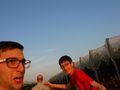
| + | Image: 2011-05-25 40 16 celebrating.jpg | Yes,yes!We are strong!Yes we made it! | ||
| + | Image: 2011-05-25 40 16 celebrating2.jpg | Yes,yes!We are strong!Yes we made it!(2) | ||
| + | Image: 2011-05-25 40 16 comingout.jpg | my cousin and i coming out from under the trees | ||
| + | Image: 2011-05-25 40 16 thesunset.jpg | the sunset and i leaving this adventure... | ||
| + | Image: 2011-05-25 40 16 leaving.jpg | bye,bye adventure! | ||
</gallery> | </gallery> | ||
== Achievements == | == Achievements == | ||
{{#vardefine:ribbonwidth|800px}} | {{#vardefine:ribbonwidth|800px}} | ||
| − | + | {{land geohash | |
| + | | latitude = 40 | ||
| + | | longitude = 16 | ||
| + | | date = 2011-05-25 | ||
| + | | name = [[User:Batuffolo]] | ||
| + | | image = 2011-05-25 40 16 field2.jpg | ||
| + | }} | ||
| + | {{drag-along | ||
| + | | latitude = 40 | ||
| + | | longitude = 16 | ||
| + | | date = 2011-05-25 | ||
| + | | partner = Cousin,Uncle | ||
| + | | name = [[User:Batuffolo]] | ||
| + | | image = 2011-05-25 40 16 cousin.jpg | ||
| + | }} | ||
| + | {{Graticule unlocked | ||
| + | | latitude = 40 | ||
| + | | longitude = 16 | ||
| + | | date = 2011-05-25 | ||
| + | | name = [[User:Batuffolo]] | ||
| + | }} | ||
| − | |||
| − | |||
| − | |||
| − | |||
| − | |||
| − | |||
| − | |||
| − | |||
| − | |||
| − | |||
| − | |||
[[Category:Expeditions]] | [[Category:Expeditions]] | ||
| − | |||
[[Category:Expeditions with photos]] | [[Category:Expeditions with photos]] | ||
| − | |||
| − | |||
| − | |||
| − | |||
| − | |||
[[Category:Coordinates reached]] | [[Category:Coordinates reached]] | ||
| − | + | {{location|IT|PU}} | |
| − | |||
| − | |||
| − | |||
| − | |||
| − | |||
| − | |||
| − | |||
| − | |||
| − | |||
Latest revision as of 05:54, 20 March 2024
| Wed 25 May 2011 in 40,16: 40.9313400, 16.9714522 geohashing.info google osm bing/os kml crox |
Location
Today's location is in a field between Casamassima,Bari and Turi,Bari.
Country:Italy; region:Apulia; district:Bari.
Participants
- Batuffolo
- my uncle
- my cousin
Expedition
After getting about 600 meters from the hash point by car, me, my uncle (who I used to drive me to the point) and my cousin (we picked him up on the way) were ready to begin the true adventure by entering a big empty field. So we walked through this (and our feet got covered with some strange annoying kind of plants...what a pain!) Then we went to a rusty fence: I felt demoralized! But we couldn't stop there. We managed to climb over it. We were excited. I don't know why we were excited...in the end we were in the middle of a deserted field enclosed by a rusty fence. But we were excited and so we started running towards the gps arrow through a vineyard. Eventually we had to kneel in order to reach the hash point. After being maddened trying to find the exact spot we found it. We took some photos, including a "stylish" one (stylish is a very badly definied term...). On the way back a melancholy sunset welcomed us and we were all sad to leave that adventure. This it has been my first time(and I hope it won't be the last one)and i won't ever forget it.
Photos

me and my uncle in the field

my "crazy"cousin and my uncle before entering the field
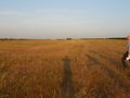
so this is the field...
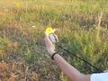
following the gps
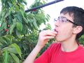
there were some cherry tree,and i was a little bit hungry...
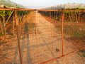
at the end of the field there was this fence:but nobody could stop us!
my cousin entering the fence.i've also entered in this way,but i was taking photos
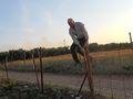
my uncle jumping over the fence...
after having climbed over the fence,this was the path which ran along two wings of trees.
here we started running as we were very near the spot
we were tunning...oh,have i already told you?
we were very near...but we had to go under the trees
let's go inside,man!
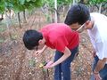
looking for the exact point...i want perfection!
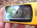
the "go to" gps screen.It indicates 0.69 m..we had reached the spot!
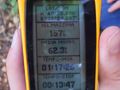
As you can see from the first panel,we were in the right point!
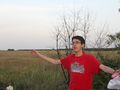
Yes,yes!We are strong!Yes we made it!
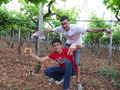
Yes,yes!We are strong!Yes we made it!(2)
my cousin and i coming out from under the trees
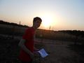
the sunset and i leaving this adventure...
bye,bye adventure!


Achievements
User:Batuffolo earned the Land geohash achievement
|
User:Batuffolo earned the Drag-along achievement
|
User:Batuffolo earned the Graticule Unlocked Achievement
|