Difference between revisions of "2010-07-13 53 -116"
From Geohashing
imported>B cereus (→Photos) |
m (per Renaming Proposal) |
||
| (3 intermediate revisions by 3 users not shown) | |||
| Line 26: | Line 26: | ||
Image:2010-07-13 53 -116 05.JPG | I'm very glad I brought my safety rubber boots. | Image:2010-07-13 53 -116 05.JPG | I'm very glad I brought my safety rubber boots. | ||
Image:2010-07-13 53 -116 06.JPG | A slippery slope. | Image:2010-07-13 53 -116 06.JPG | A slippery slope. | ||
| − | Image:2010-07-13 53 -116 07. | + | Image:2010-07-13 53 -116 07.PNG | iPhone evidence, the metadata of pictures now on the iPhone show gps coordinates, but it doesn't transfer onto the wiki for some reason. |
| − | Image:2010-07-13 53 -116 08. | + | Image:2010-07-13 53 -116 08.PNG | The patterns made by selective forestry when viewed from satellite are pretty cool. |
Image:2010-07-13 53 -116 09.JPG | SMILE | Image:2010-07-13 53 -116 09.JPG | SMILE | ||
Image:2010-07-13 53 -116 10.JPG | The internet was here! | Image:2010-07-13 53 -116 10.JPG | The internet was here! | ||
| Line 39: | Line 39: | ||
| image = | | image = | ||
}} | }} | ||
| − | {{ | + | {{Graticule unlocked |
| latitude = 53 | | latitude = 53 | ||
| longitude = -116 | | longitude = -116 | ||
| Line 50: | Line 50: | ||
[[Category:Coordinates reached]] | [[Category:Coordinates reached]] | ||
[[Category:Expeditions with photos]] | [[Category:Expeditions with photos]] | ||
| + | {{location|CA|AB|YH}} | ||
Latest revision as of 06:10, 20 March 2024
| Tue 13 Jul 2010 in 53,-116: 53.7297663, -116.8136431 geohashing.info google osm bing/os kml crox |
Location
In the forest north of the city of Edson. An area mostly used for forestry, and the oil and gas industries.
Participants
Plans
Working at a rig within 10 km from the coordinates, so I'll grab this on the way to Edson for groceries.
Expedition
I'll get to this soon.
Photos
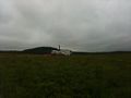
My truck parked at a producing wellhead 1.2 km NE of the hash.
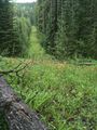
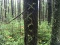
Luckily I found a seismic cutline I didn't notice on Google maps.
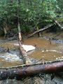
Surprise! A creek!
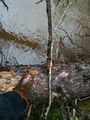
I'm very glad I brought my safety rubber boots.
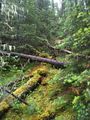
A slippery slope.
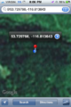
iPhone evidence, the metadata of pictures now on the iPhone show gps coordinates, but it doesn't transfer onto the wiki for some reason.
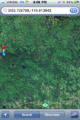
The patterns made by selective forestry when viewed from satellite are pretty cool.

SMILE
The internet was here!


B cereus earned the Land geohash achievement
|
B cereus earned the Graticule Unlocked Achievement
|