Difference between revisions of "2010-04-18 24 110"
imported>Jevanyn m |
m (per Renaming Proposal) |
||
| (3 intermediate revisions by 3 users not shown) | |||
| Line 31: | Line 31: | ||
In China all the roads seem to be built like those new designer suburbs in the mortgage belt back home: all disconnected branching structures, rather than efficient networks. This means that the road builders seem to feel they have failed if there is more than one way to get anywhere. This made things bad. | In China all the roads seem to be built like those new designer suburbs in the mortgage belt back home: all disconnected branching structures, rather than efficient networks. This means that the road builders seem to feel they have failed if there is more than one way to get anywhere. This made things bad. | ||
| + | |||
| + | To make matters worse, I soon discovered that the highway I'd been on at the beginning was actually the correct one and that I should have just stayed on it rather than freaking out and heading to the hills. | ||
In the end I completely gave up and tried to ride back to Yangshuo for a second shot, if daylight permitted. So I asked the local farmers which way to Yangshuo. To my surprise, they pointed in the direction I was headed, rather than back the way I'd come - which suit me fine. What also suit me fine was that I soon stumbled upon a road I'd cycled on only two days ago on a previous bike ride (okay so I did do a FEW other things than sitting on my arse in the last week). My bearings back I made the decision to follow a concrete paved road headed towards the hash and away from home. A good move. | In the end I completely gave up and tried to ride back to Yangshuo for a second shot, if daylight permitted. So I asked the local farmers which way to Yangshuo. To my surprise, they pointed in the direction I was headed, rather than back the way I'd come - which suit me fine. What also suit me fine was that I soon stumbled upon a road I'd cycled on only two days ago on a previous bike ride (okay so I did do a FEW other things than sitting on my arse in the last week). My bearings back I made the decision to follow a concrete paved road headed towards the hash and away from home. A good move. | ||
| Line 38: | Line 40: | ||
But there was a problem. Despite the foggy and rainy weather I could make out an enormous karst formation right where the hash should be (this area is surrounded by limestone mountins jutting vertically out of the ground, like Avatar without the unobtainium). | But there was a problem. Despite the foggy and rainy weather I could make out an enormous karst formation right where the hash should be (this area is surrounded by limestone mountins jutting vertically out of the ground, like Avatar without the unobtainium). | ||
| − | Resignedly, I abandoned my bike and began clambering through the dense undergrowth, following animal tracks, towards the hill. The hash still lay 250m away. I knew I wouldn't make it. | + | Resignedly, I abandoned my bike and began clambering through the dense undergrowth, my Goretex jacket getting torn up by the thorns, following animal tracks, towards the hill. The hash still lay 250m away. I knew I wouldn't make it. |
But no, as it happened, the hash was just on the other side of the hill, so I could skirt around it. When my GPS finally declared me to be 40m from the hash I suddenly went from thinking I would certainly fail, to thinking I would certainly succeed. At 10m to go, the undergrowth opened up into a farm - clearly the terminus of the road I'd been trying to follow from the beginning. I took some photos and head home, after relocating my bike for a scary instant, drinking 1.5 litres of orange juice and listening to an atheist podcast on my ipod as I rode the untrafficked roadways. | But no, as it happened, the hash was just on the other side of the hill, so I could skirt around it. When my GPS finally declared me to be 40m from the hash I suddenly went from thinking I would certainly fail, to thinking I would certainly succeed. At 10m to go, the undergrowth opened up into a farm - clearly the terminus of the road I'd been trying to follow from the beginning. I took some photos and head home, after relocating my bike for a scary instant, drinking 1.5 litres of orange juice and listening to an atheist podcast on my ipod as I rode the untrafficked roadways. | ||
Back in Yangshuo I also experienced a small coup - my dad had set me the task of finding a cafe he'd enjoyed here in the 70's called Mickey Mao's (clever eh?). I found a place called Minnie Mao's and sure enough, the staff told me it had changed its name in 1991. I had a 'Black Beer' there to celebrate both victories. | Back in Yangshuo I also experienced a small coup - my dad had set me the task of finding a cafe he'd enjoyed here in the 70's called Mickey Mao's (clever eh?). I found a place called Minnie Mao's and sure enough, the staff told me it had changed its name in 1991. I had a 'Black Beer' there to celebrate both victories. | ||
| + | |||
| + | Estimated total ride: About 60 kms, but hard to tell | ||
| + | Time of hash: 3pm | ||
| + | Total time for geohash: 5 hours. | ||
== Photos == | == Photos == | ||
| Line 53: | Line 59: | ||
Image:Geohash 2010 04 18 24 110 west.JPG|West view | Image:Geohash 2010 04 18 24 110 west.JPG|West view | ||
Image:Geohash 2010 04 18 24 110 south.JPG|South view | Image:Geohash 2010 04 18 24 110 south.JPG|South view | ||
| + | Image:Geohash 2010 04 18 24 110 Felix.JPG|Me at the hash | ||
Image:Geohash 2010 04 18 24 110 view from hash.JPG|Hash view of the plain | Image:Geohash 2010 04 18 24 110 view from hash.JPG|Hash view of the plain | ||
Image:Geohash 2010 04 18 24 110 undergrowth.jpg|The undergrowth | Image:Geohash 2010 04 18 24 110 undergrowth.jpg|The undergrowth | ||
| Line 70: | Line 77: | ||
| latitude = 24 | | latitude = 24 | ||
| longitude = 110 | | longitude = 110 | ||
| − | | date = 2010- | + | | date = 2010-04-18 |
| name = [[User:Felix Dance|Felix Dance]] | | name = [[User:Felix Dance|Felix Dance]] | ||
| image = Geohash 2010 01 23 18 99 Felix.JPG | | image = Geohash 2010 01 23 18 99 Felix.JPG | ||
| Line 80: | Line 87: | ||
| latitude = 24 | | latitude = 24 | ||
| longitude = 110 | | longitude = 110 | ||
| − | | date = 2010- | + | | date = 2010-04-18 |
| name = Felix Dance | | name = Felix Dance | ||
| distance = 25kms return | | distance = 25kms return | ||
| Line 87: | Line 94: | ||
}} | }} | ||
| − | {{ | + | {{Graticule unlocked |
| latitude = 24 | | latitude = 24 | ||
| longitude = 110 | | longitude = 110 | ||
| − | | date = 2010- | + | | date = 2010-04-18 |
| name = [[User:Felix Dance|Felix Dance]] | | name = [[User:Felix Dance|Felix Dance]] | ||
| image = Geohash 2010 01 23 18 99 Felix.JPG | | image = Geohash 2010 01 23 18 99 Felix.JPG | ||
| Line 101: | Line 108: | ||
[[Category:Coordinates reached]] | [[Category:Coordinates reached]] | ||
[[Category:China]] | [[Category:China]] | ||
| + | {{location|CN|GX}} | ||
Latest revision as of 06:14, 20 March 2024
| Sun 18 Apr 2010 in 24,110: 24.8919619, 110.4373027 geohashing.info google osm bing/os kml crox |
The Place
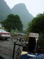
13kms or so to the north of Yangshuo, China.
Who Went
- Felix Dance - by bicycle.
Expedition
Felix Dance
I've been staying in a dorm here in Yangshuo, China, for the last week, chilling out, drinking beer with my Scandinavian mates here and... not much else. Oh, checking my email and, sometimes, the nearest geohash.
It was on one of these occasions that I discovered that there was an accessible geohash the next day, just 13kms north of town. I had planned to leave with the others to Guilin, but this discovery changed everything.
At about midday I got up (yes, we've also been having some pretty late nights on the town here), farewelled my companions, and hired a mountain bike to attack the hash.
The plan was simple. Ride north 10kms up the National Highway 321, then, when my GPS said the hash was directly to the east, take the smaller road in that direction 5 kms or so directly to the hash. These were also the only Google-marked roads anywhere near the hash so it shouldn't be too hard.
But.
After about 6kms on this highway I suddenly got the feeling that I'd taken THE WRONG ROAD (there are a lot of highways around here), so, in a desperate attempt to intersect the correct highway, I headed east early - straight onto the unsealed laneways and muddy animal tracks of rural China.
After about THREE HOURS of riding around in circles: along rivers, up hills (big ones too), through farms and into houses I soon realised that I was getting nowhere fast - I was actually heading BACKWARDS - back to Yangshuo, despite taking the most hash-directed choice at every turn.
In China all the roads seem to be built like those new designer suburbs in the mortgage belt back home: all disconnected branching structures, rather than efficient networks. This means that the road builders seem to feel they have failed if there is more than one way to get anywhere. This made things bad.
To make matters worse, I soon discovered that the highway I'd been on at the beginning was actually the correct one and that I should have just stayed on it rather than freaking out and heading to the hills.
In the end I completely gave up and tried to ride back to Yangshuo for a second shot, if daylight permitted. So I asked the local farmers which way to Yangshuo. To my surprise, they pointed in the direction I was headed, rather than back the way I'd come - which suit me fine. What also suit me fine was that I soon stumbled upon a road I'd cycled on only two days ago on a previous bike ride (okay so I did do a FEW other things than sitting on my arse in the last week). My bearings back I made the decision to follow a concrete paved road headed towards the hash and away from home. A good move.
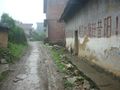
After riding along this road for another hour or so (and making a wrong turn that required another 20 minutes backtracking) I got to a small village within 1km of the hash.
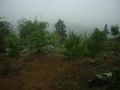
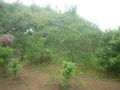
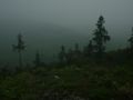
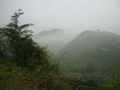
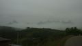
But there was a problem. Despite the foggy and rainy weather I could make out an enormous karst formation right where the hash should be (this area is surrounded by limestone mountins jutting vertically out of the ground, like Avatar without the unobtainium).
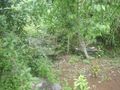
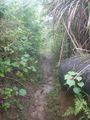
Resignedly, I abandoned my bike and began clambering through the dense undergrowth, my Goretex jacket getting torn up by the thorns, following animal tracks, towards the hill. The hash still lay 250m away. I knew I wouldn't make it.
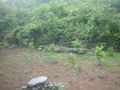
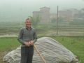
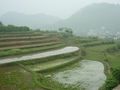
But no, as it happened, the hash was just on the other side of the hill, so I could skirt around it. When my GPS finally declared me to be 40m from the hash I suddenly went from thinking I would certainly fail, to thinking I would certainly succeed. At 10m to go, the undergrowth opened up into a farm - clearly the terminus of the road I'd been trying to follow from the beginning. I took some photos and head home, after relocating my bike for a scary instant, drinking 1.5 litres of orange juice and listening to an atheist podcast on my ipod as I rode the untrafficked roadways.
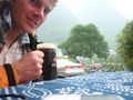
Back in Yangshuo I also experienced a small coup - my dad had set me the task of finding a cafe he'd enjoyed here in the 70's called Mickey Mao's (clever eh?). I found a place called Minnie Mao's and sure enough, the staff told me it had changed its name in 1991. I had a 'Black Beer' there to celebrate both victories.
Estimated total ride: About 60 kms, but hard to tell Time of hash: 3pm Total time for geohash: 5 hours.
Photos
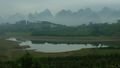
Lake
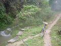
Path to the hash
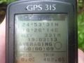
GPS proof
North view
East view
West view
South view
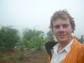
Me at the hash
Hash view of the plain
The undergrowth

Hill at the hash
The village
Local farmer
Valley near the hash
Hills in the distance
Rice paddies
Me with beer!
Beer and bike
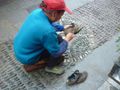
Shoe shine


Felix Dance earned the Land geohash achievement
|
Felix Dance earned the Bicycle geohash achievement
|
Felix Dance earned the Graticule Unlocked Achievement
|