Difference between revisions of "2009-11-10 -7 110"
imported>Felix Dance (→Photos: More photos) |
m (per Renaming Proposal) |
||
| (4 intermediate revisions by 3 users not shown) | |||
| Line 8: | Line 8: | ||
== The Place == | == The Place == | ||
| − | In a paddy field about 20 kms south west of Yogyakarta | + | In a paddy field about 20 kms south west of Yogyakarta, near a town called Watan. |
== Who Went == | == Who Went == | ||
| Line 32: | Line 32: | ||
The ride home displayed an amazing sunset, losing each other again, and some brief night riding in crazy yet awesome Yogya. | The ride home displayed an amazing sunset, losing each other again, and some brief night riding in crazy yet awesome Yogya. | ||
| − | Time of hash: 4 o'clockish. Awesome hash, and the first in Indonesia (come on Indonesians!). | + | Time of hash: 4 o'clockish. Awesome hash, and the first in Indonesia (come on Indonesians!). [http://maps.google.com/maps?f=d&source=s_d&saddr=-7.790042,110.363073&daddr=-7.854495%C2%B0,+110.149983%C2%B0&geocode=%3BFWEmiP8dX8GQBg&hl=en&mra=dme&mrcr=0&mrsp=0&sz=15&sll=-7.797398,110.366721&sspn=0.023938,0.045447&ie=UTF8&ll=-7.833112,110.273552&spn=0.191487,0.363579&t=p&z=12 Here's] a map of our route. |
Now for that volcano trek... | Now for that volcano trek... | ||
| Line 50: | Line 50: | ||
Image:CIMG2238.JPG|Our mode of transport | Image:CIMG2238.JPG|Our mode of transport | ||
Image:CIMG2242.JPG|Dinner at the warun | Image:CIMG2242.JPG|Dinner at the warun | ||
| − | Image:CIMG2245.JPG|The fruit market | + | Image:CIMG2245.JPG|The fruit market at Watan |
</gallery> | </gallery> | ||
| Line 59: | Line 59: | ||
| date = 2009-11-10 | | date = 2009-11-10 | ||
| name = [[User:Felix Dance|Felix Dance]], Anh and Jasper | | name = [[User:Felix Dance|Felix Dance]], Anh and Jasper | ||
| − | | image = | + | | image = CIMG2233.JPG |
}} | }} | ||
| − | {{ | + | {{Graticule unlocked |
| latitude = -7 | | latitude = -7 | ||
| Line 69: | Line 69: | ||
| date = 2009-11-10 | | date = 2009-11-10 | ||
| name = [[User:Felix Dance|Felix Dance]], Anh and Jasper | | name = [[User:Felix Dance|Felix Dance]], Anh and Jasper | ||
| − | | image = | + | | image = CIMG2233.JPG |
}} | }} | ||
| Line 76: | Line 76: | ||
[[Category:Expeditions with photos]] | [[Category:Expeditions with photos]] | ||
[[Category:Coordinates reached]] | [[Category:Coordinates reached]] | ||
| + | {{location|ID|JW|YO}} | ||
Latest revision as of 06:20, 20 March 2024
| Tue 10 Nov 2009 in -7,110: -7.8544946, 110.1499832 geohashing.info google osm bing/os kml crox |
The Place
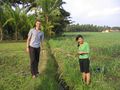
In a paddy field about 20 kms south west of Yogyakarta, near a town called Watan.
Who Went
- Felix Dance - by motor scooter
- Jasper - going with Felix
- Ahn - on the back of Jasper's motor scooter
Expedition
Felix Dance, Jasper and Anh
Well, Anh and I got up from our hotel in Yogyakarta, Java, Indonesia, where we've both been independently traveling in different directions for the past few days but, with a Dutch guy called Jasper, have found ourselves somehow thrown together. I was describing Geohashing in my home city of Melbourne, Australia and they were interested enough to humour me in checking where today's point was online.
We found that it was quite accessible. In fact, only about 30kms from here - within easy riding distance by motor scooter. So after Anh and I checked out the 'Bird Market' in town, and with Jasper organised to do a midnight hike up Mount Merapi (Java's most active volcano) later today, we headed off.
We had hired two scooters with Jasper and Anh on one and I on the other. We passed some amazing scenery along the way, battled with Java's crazy traffic, lost each other for a while and found each other again without the luxury of mobile phones, and slowly zeroed in on the location.
Within 500m we had to turn off an already side road onto an unsealed motorbike track by the side of a large irrigation channel. Soon it was time to abandon our bikes and head the last 50m on foot, which we found to be surprisingly easy despite occasionally slipping into the mud of the paddy field.
We quickly got to the point, which was amazing in how beautiful the surroundings were and perfect the level of accessibility. We stopped to take numerous photos, being unregarded by a local farmer on whose land we seemed to be. Finally we left the way we came, stopping nearby for some not-very-inspirational-yet-vastly-cheap food and then a bit further on for some delicious fruit at a fruit market.
The ride home displayed an amazing sunset, losing each other again, and some brief night riding in crazy yet awesome Yogya.
Time of hash: 4 o'clockish. Awesome hash, and the first in Indonesia (come on Indonesians!). Here's a map of our route.
Now for that volcano trek...
Photos

GPS Proof

More proof

Anh, Jasper and Felix
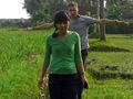
Jasper and Anh

East view

South view

West view

North view
Walking back
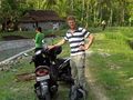
Our mode of transport
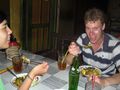
Dinner at the warun
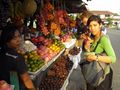
The fruit market at Watan


Felix Dance, Anh and Jasper earned the Land geohash achievement
|
Felix Dance, Anh and Jasper earned the Graticule Unlocked Achievement
|