Difference between revisions of "2009-09-25 35 -107"
imported>Redaragorn (New page: {{meetup graticule | lat=35 | lon=-107 | date=2009-09-17 | graticule_name=Grants | graticule_link=Grants, New Mexico }} === redaragorn === I knew that I'd have time t...) |
m (per Renaming Proposal) |
||
| (5 intermediate revisions by 2 users not shown) | |||
| Line 1: | Line 1: | ||
{{meetup graticule | {{meetup graticule | ||
| + | | map=<map lat="35" lon="-107" date="2009-09-25" /> | ||
| lat=35 | | lat=35 | ||
| lon=-107 | | lon=-107 | ||
| − | | date=2009-09- | + | | date=2009-09-25 |
| − | |||
| − | |||
}} | }} | ||
| − | |||
| − | + | == Location == | |
| − | + | In a small ravine among rolling hills in the Zuni Mountains south and west of Grants. | |
| − | + | == Participants == | |
| − | + | ||
| − | + | * [[User:Redaragorn|Redaragorn]] | |
| − | + | ||
| − | + | == Plans == | |
| − | |||
| − | |||
| − | + | Take the dirt roads as far as I could and hike the rest of the distance to the hash point. The entire area was located on National Forest land, so access wasn't an issue at all. | |
| + | == Expedition == | ||
After missing out on the Albuquerque geohash on the way west, we finally made it out to Grants and headed south after the Malpais. We headed northwest into the Zuni Mountains on the bumpy road up Bonita Canyon. After a few miles, I parked the car and walked a half mile or so over to the geohash. Little squirt made the entire walk there and back on his own despite the fact that it was up and down most all of the way. He did good, and was a willing participant in my drag-along achievement. | After missing out on the Albuquerque geohash on the way west, we finally made it out to Grants and headed south after the Malpais. We headed northwest into the Zuni Mountains on the bumpy road up Bonita Canyon. After a few miles, I parked the car and walked a half mile or so over to the geohash. Little squirt made the entire walk there and back on his own despite the fact that it was up and down most all of the way. He did good, and was a willing participant in my drag-along achievement. | ||
Check out the track [http://www.trailguru.com/wiki/index.php/Track:99YM?units=imperial here]. | Check out the track [http://www.trailguru.com/wiki/index.php/Track:99YM?units=imperial here]. | ||
| − | {{ | + | {{Graticule unlocked | latitude = 35| longitude = -107 | date = 2009-09-25 | name = [[User:Redaragorn|Redaragorn]] }} |
| − | {{ | + | {{Drag-along | latitude = 35 | longitude = -107 | date = 2009-09-25 | partner = his son | name = Redaragorn | image = 2009-09-25 35 -107 - Little guy.jpg }} |
| + | == Pictures == | ||
| − | + | <gallery> | |
| − | + | Image:2009-09-25 35 -107 - GPS.jpg|GPS coordinates to prove we're at the hash. | |
| + | Image:2009-09-25 35 -107 - Little guy.jpg|My little guy with requisite goofy grin (trust me, ALL of his grins are goofy!). | ||
| + | Image:2009-09-25 35 -107 - me.jpg|Me with my goofy grin. | ||
| + | |||
| + | </gallery> | ||
| − | |||
| − | |||
[[Category:Expeditions]] | [[Category:Expeditions]] | ||
[[Category:Coordinates reached]] | [[Category:Coordinates reached]] | ||
| + | {{location|US|NM|CI}} | ||
Latest revision as of 06:23, 20 March 2024
| Fri 25 Sep 2009 in 35,-107: 35.0228332, -107.9926008 geohashing.info google osm bing/os kml crox |
Location
In a small ravine among rolling hills in the Zuni Mountains south and west of Grants.
Participants
Plans
Take the dirt roads as far as I could and hike the rest of the distance to the hash point. The entire area was located on National Forest land, so access wasn't an issue at all.
Expedition
After missing out on the Albuquerque geohash on the way west, we finally made it out to Grants and headed south after the Malpais. We headed northwest into the Zuni Mountains on the bumpy road up Bonita Canyon. After a few miles, I parked the car and walked a half mile or so over to the geohash. Little squirt made the entire walk there and back on his own despite the fact that it was up and down most all of the way. He did good, and was a willing participant in my drag-along achievement.
Check out the track here.
Redaragorn earned the Graticule Unlocked Achievement
|
Redaragorn earned the Drag-along achievement
|
Pictures
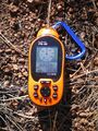
GPS coordinates to prove we're at the hash.
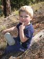
My little guy with requisite goofy grin (trust me, ALL of his grins are goofy!).

Me with my goofy grin.


